Mount Powell + Eagles Nest — combination day (Gore Range)
At a glance — recommended day
13.8 mi · 5,415 ft gain · Class 3 · 2 peaks · ~3.1 h drive
NOAA weather link: Mount Powell + Eagles Nest Weather
Drive from Boulder: 3h 5m via Google Maps
CalTopo research map: https://caltopo.com/m/8N8L51C
Researched: 2026-06-02
Status in Peak Checklist: Both 0 ascents (unclimbed). Mount Powell is the highest peak in the Gore Range.
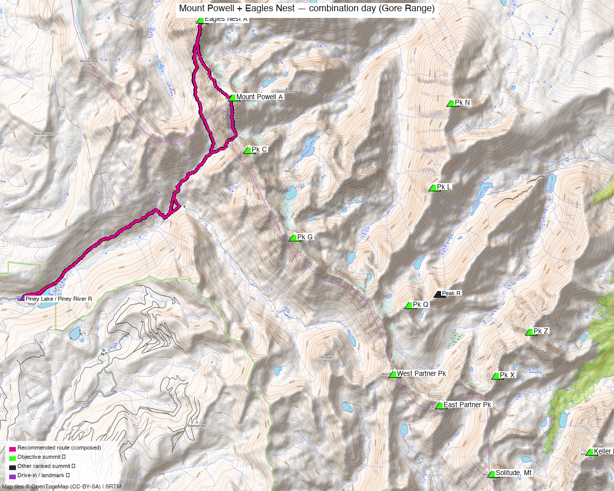
Note: the recommended route was distilled from 18 recorded GPS tracks of real trips (14ers.com · ListsofJohn · peakbagger) — all layered on the interactive CalTopo research map.
Other climbers: Emily Sharpe — 1 of 2 (Mount Powell A) · Shawn D Keil — 1 of 2 (Mount Powell A)
Peaks covered
| Mount Powell A | Eagles Nest A | |
|---|---|---|
| Elevation (LiDAR) | 13,556' | 13,419' |
| Lat / Lon | 39.76009, −106.34074 | 39.77559, −106.3504 |
| Class (standard) | 2 | 3 |
| 14ers.com peak page | 10218 | 10219 |
| listsofjohn.com | 245 | 380 |
| peakbagger.com | pid 5774 | pid 38390 |
| Peak DB id | 245 | 380 |
| Range / Wilderness | Gore / Eagles Nest Wilderness | same |
The two summits are 1.19 mi apart — a natural, well-established pairing.
Why these two together: a standard combination. The recent trip reports that hit either peak do both in one outing:
- elijahdgendron (2025-08-17) — Powell + Eagles Nest
- josephnephi (2025-07-07) — Powell + Eagles Nest
- whileyh (2025-07-01) — Powell + Eagles Nest (+ "Dwarf Pyramid" 12,669')
- datum (2020-11-07) — Powell + Eagles Nest (+ "East Corner")
Combos (ranked 13er+ rule): each is a true ranked partner for the other (13,556' + 13,419'). Both unclimbed — this is the efficient way to bag the Gore high point and its neighbor in one (big) day.
Recommended plan — Piney Lake ⭐
A long, committing alpine day for the pair from Piney Lake. (Some logged tracks run longer/bigger with extra sub-peaks.)
- From Piney Lake, follow the Upper Piney River trail east up the valley.
- Climb out of the basin toward the Powell massif (the standard line gains the west/southwest side of Powell).
- Mount Powell (13,556', Class 2): the Gore Range high point — talus/boulder to the summit.
- Traverse N ~1.2 mi to Eagles Nest (13,419', Class 3): the connecting ridge/final summit involves Class 3 scrambling on Gore-quality rock. This is the technical crux of the day.
- Return to Piney Lake the way you came.
Order/direction varies by TR — some climb Eagles Nest first, some Powell first. Study the GPX on the research map for the exact connecting line; the ridge has route-finding and Class 3 sections.
Getting there — drive & trailhead
| Drive from Boulder | 3h 5m via Google Maps (129 mi, origin: 1162 Peakview Circle) — the closest of the deep-Gore 13ers |
| Trailhead | Piney Lake / Piney River Ranch (~9,350'), ~11 mi up Red Sandstone Rd / Piney Lake Rd, N of Vail |
| Vehicle | Piney Lake Rd is dirt — washboarded but 2WD-passable in dry conditions; rough/muddy when wet. Piney River Ranch charges day-use parking. |
| Approach | From Piney Lake, the Upper Piney River trail east, then up toward Kneeknocker Pass / Powell's west approach |
Gear & season
- Best window: July through September. The Gore holds snow late and the approach is long — mid-summer for the dry standard lines.
- Rock: classic Gore Range — solid where steep, but loose blocks; Eagles Nest's Class 3 demands attention.
- Length: this is a big day. Alpine start; watch the long exit.
- Storms: standard high-Gore afternoon storm exposure on a long ridge — be moving early.
- Access: Piney Lake Rd can be rough/muddy after rain; Piney River Ranch is private land at the trailhead (day-use parking fee, seasonal) — be respectful of the ranch operation. Eagles Nest Wilderness (White River NF) — no permits required; standard wilderness rules (no motorized, leash dogs, groups ≤ 15).
- Cell: no 14ers.com community-DB reports for either summit. Piney Lake TH / Upper Piney basin: likely dead — deep valley behind the Gore crest, shadowed from the I-70/Vail corridor. Powell / Eagles Nest summits: possible signal on top — some LOS toward the Vail / I-70 corridor to the south, but not reliable. Carry an InReach — long, committing day with a Class 3 crux and a deep-valley approach.
Trip reports & GPX (all three sources)
| Source | Notable TRs | GPX |
|---|---|---|
| listsofjohn.com | elijahdgendron 2025, josephnephi 2025, whileyh 2025, datum 2020 (all Powell + Eagles Nest); cougar 2023, John Kirk 2012 | 18036 ⭐ combo, 17847, 17866, 9122 |
| 14ers.com | 23 Powell TRs incl. "From Piney Ranch"; per-peak GPX library | 9 files |
| peakbagger.com (logged in, Kyle Knutson) | ascent tracks for both pids | 6 files |
GPX collected: 21 track files across all three sources — layered on the CalTopo research map.
Sources checked: 14ers.com · listsofjohn.com · peakbagger.com