Mount Silverthorne (13,361') via Deluge Lake — Gore Range
Other climbers: Emily Sharpe — ✓ climbed · Shawn D Keil — not yet
At a glance — recommended day
14.5 mi · 4,763 ft gain · Class 2 · 1 peak · ~2.94 h drive
NOAA weather link: Mount Silverthorne (13,361') via Deluge Lake — Gore Range Weather
Drive from Boulder: 3h 00m via Google Maps
CalTopo research map: https://caltopo.com/m/G2FBNB5
Researched: 2026-08-09
Status in Peak Checklist: unclimbed. Silverthorne is the signature 13er of the northern Gore and Kyle's only unclimbed ranked summit directly accessed from the paved Deluge Lake / Gore Creek TH on the East Vail side — Grand Traverse and North Traverse on the same connecting ridge are already climbed. Class 2+ long day-push out of the same trailhead the Mt Valhalla + Snow Pk report uses, so it's the third and final day out of that lot.
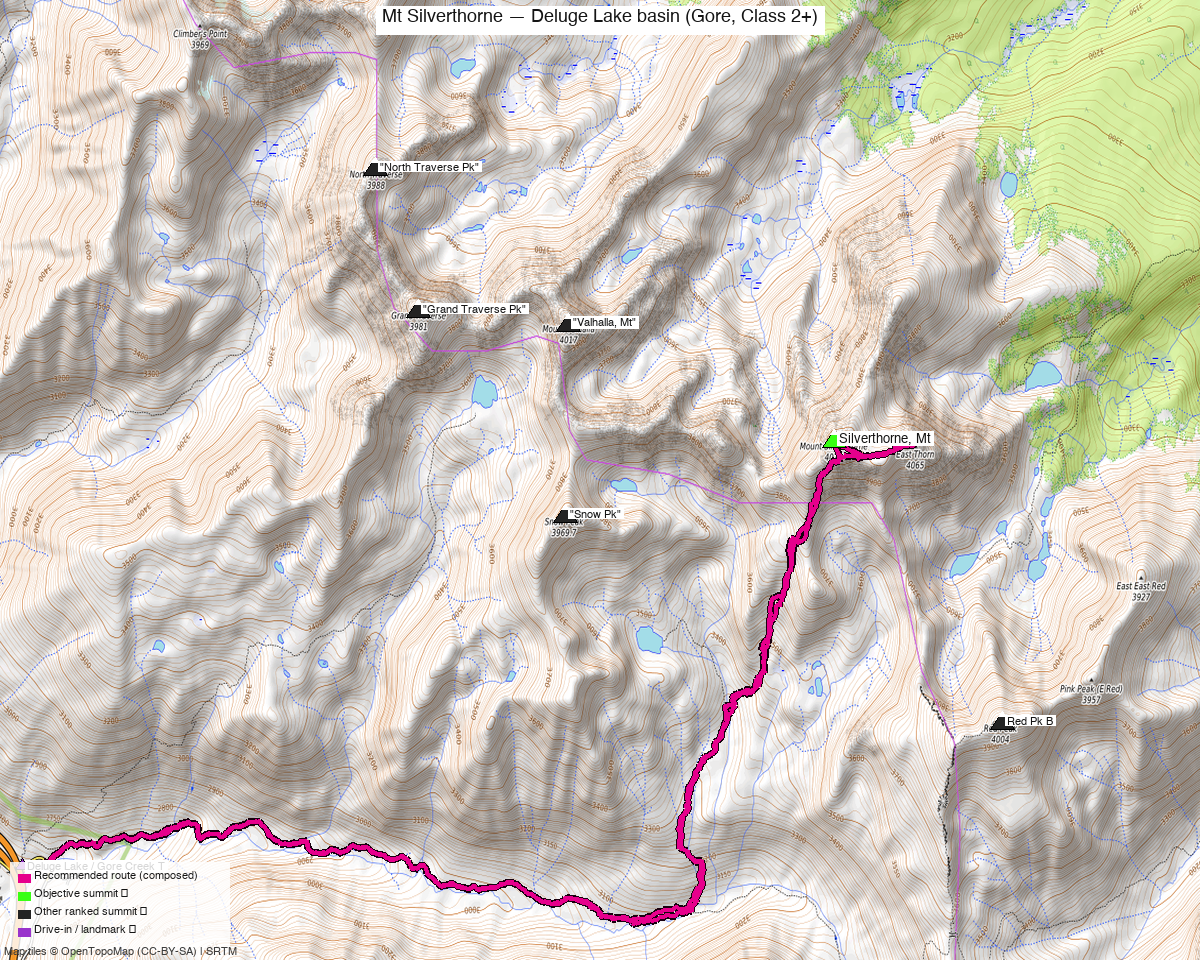
Note: the recommended route was distilled from 8 recorded GPS tracks of real trips (14ers.com · ListsofJohn · peakbagger) — all layered on the interactive CalTopo research map.
Peaks covered
Mount Silverthorne (13,361' by LiDAR; pre-LiDAR maps show 13,357'; peakbagger measures 13,360.6') is the signature peak of the northern Gore Range — LoJ CO rank #347, Colorado prominence rank #344. Line-parent and proximate parent is Mount Powell (13,580', 10.9 mi NW); isolation is 10.8 mi. It sits inside the Eagles Nest Wilderness (White River National Forest, Summit County, Willow Lakes USGS quad). The alternate name Willow Benchmark is the pre-USGS designation — the summit carries NGS PID KL0611 and climb13ers uses the compound name "Willow BM / Mt. Silverthorne". No permits or fees for day use; standard wilderness rules apply (leashed dogs, no wheels or motorized travel, LNT camping off-trail).
| Peak | Elev | Class | CO rank | Status |
|---|---|---|---|---|
| Silverthorne, Mt | 13,361' | 2 | 349 | unclimbed |
Recommended route — the recommended line ⭐
14.5 mi · ~4,763 ft, Class 2+ — a long out-and-back on the same corridor from the Gore Creek TH. The Deluge Lake Trail #2014 branches north off the Gore Creek Trail almost immediately and climbs steep switchbacks ~4 mi up to Deluge Lake (~11,700'). From the lake, cross east up a boulder-strewn stream drainage past a giant boulder step, angle east to Snow Pass (~12,600'), then descend south and east to Snow Lake and continue down to a set of ponds where the creek turns south. A short Class 2 gully on the east side of the creek scrambles onto a broad tundra terrace SW of Silverthorne's south ridge; walk east to the ridge saddle and turn north up the ridge on tundra and embedded boulder. About 200' up the ridge, climb13ers' recommended variant contours right into a tundra-filled bowl and finishes up a large, rubble-filled couloir (Class 2+, notoriously loose — climb13ers describes it as "one of those rubble-filled types where most every rock is precariously placed atop another and you never have secure footing") to the summit block. Staying on the S ridge crest all the way is a Class 2 alternative — less loose, only marginally longer, and probably the pick if the couloir looks miserable that day. Recorded parties all combine everything into ONE long day rather than the climb13ers backpack basecamp, and the beta explicitly validates the day-push option; six of the eight swept recordings start from this TH and recorded RTs cluster 13.8–16.8 mi around the composed 14.5 mi line.
Route sequence
- Gore Creek TH (8,710') — paved lot on the E-SE curve of Bighorn Rd just before Gore Creek Campground. Head east briefly on the Gore Creek Trail; the Deluge Lake Trail #2014 branches left almost immediately.
- Deluge Lake Trail switchbacks — steep, well-defined climb through spruce/fir forest, ~3,000' gain over ~4 mi. climb13ers calls it "a steep trail hike of over 4 miles one way before beginning the main ascent."
- Deluge Lake (~11,700') — small alpine lake in an open cirque; the climb13ers backpack basecamp. Skirt the north shore and pick up a use trail east up the outlet drainage.
- Boulder step + tundra bench (~12,000') — a giant boulder step, then a bench-type boulder field SW of Mt Valhalla's south ridge.
- Snow Pass (~12,600') — angle east up tundra where a use trail comes and goes; top out on the pass between Valhalla and Snow Peak.
- Snow Lake and ponds (~11,900') — descend south and east from the pass down to Snow Lake, then continue east down the drainage to a set of ponds where the creek turns south.
- Gully onto the terrace (~12,700') — on the east side of the creek, a narrow Class 2 gully with a "good goat path" scrambles up onto a broad, gently sloping tundra terrace SW of Silverthorne's south ridge.
- South-ridge saddle (~12,900') — walk east across the terrace to the S ridge saddle; turn north up the ridge on tundra and embedded boulder.
- Tundra bowl + couloir (~13,200') — about 200' up the ridge, contour right into a tundra-filled bowl for ~300 ft, then up the large rubble-filled couloir (Class 2+). Alternative: stay on the ridge crest all the way, Class 2, less loose but slower boulder-hopping.
- Summit (13,361') — short walk north across the summit plateau to the true high point. NGS benchmark KL0611 (Willow BM) on top.
- Return — reverse the line back to the TH (~7 mi). No loop variant exists at this trailhead — there's no second trail back to Bighorn Rd.
Getting there — Deluge Lake / Gore Creek TH (8,710')
| Drive from Boulder | 3h 00m via Google Maps |
| Trailhead | Deluge Lake / Gore Creek TH, 39.62771, -106.27486, 8,710' |
| Road | Paved the whole way — I-70 to Exit 180 (East Vail), then south on Bighorn Rd for 2.3 mi east through condos and residential to the paved parking lot on the E-SE curve just before Gore Creek Campground. climb13ers rates it "Passenger Car Accessible." Very popular TH — climb13ers warns "on weekends, the available parking fills beyond capacity; arrive early." |
| Land | White River National Forest / Eagles Nest Wilderness (Summit County, Willow Lakes USGS quad). No permits or fees for day use; standard wilderness rules (leashed dogs, no wheels/motorized travel, LNT camping). Fee car camping at the adjacent Gore Creek NF Campground (vault toilets, water) if you want to sleep at the TH before an early start. |
Gear & season
- Prime window: mid-July through late September. Five of the eight swept tracks are peak-summer (July–September); three are shoulder (early June + late October) and none are winter. Upper basins around Snow Pass hold snow into late July — climb13ers' summit photos are late summer with none.
- Off-season: the early-June recordings show a snowbound upper basin. The Deluge Lake → Snow Pass gully can hold snow into July; carry an ice axe if you're going in a heavy-snow year or early in the window.
- Gear: standard hiking kit for peak season — poles earn their keep on ~4 mi of steep trail in each direction and on the loose descent off the upper couloir. No helmet strictly required on the standard line (no overhead terrain, no scrambling in fall zones), but the couloir is notoriously loose. Traction (microspikes) is worth having through mid-July.
- Storms: this is a long day above treeline — ~11 miles of tundra and boulder-talus above Deluge Lake with nowhere to shelter. Start pre-dawn; be off the ridge by early afternoon.
- Cell: decent LTE at the East Vail TH; expect to lose it once you drop into the Deluge Lake drainage and again at Snow Pass. The summit is line-of-sight to Vail and often gets a weak signal. Carry an InReach — 7+ miles from the road once past Deluge Lake.
Other considerations
- Snow Peak from a Deluge Lake basecamp: climb13ers' preferred plan is actually a 2-day backpack to Deluge Lake with Snow Peak (13,039', Class 3, unclimbed, 1.59 mi SW) picked up the same day from lake camp — the beta explicitly pairs Snow Peak "CLIMBED WITH MOUNT SILVERTHORNE." Snow Peak is covered in Mt Valhalla + Snow Pk as its own west-side day from the same trailhead; if you're already backpacking in for Silverthorne, adding Snow Peak from the lake is the beta's day-mate and worth doing. Mt Valhalla (13,202', Class 2+, unclimbed, 1.62 mi N) is a third Deluge Lake basin peak but adds a full separate day up its S ridge from the same basecamp.
- East-side alternative from Willowbrook TH (Silverthorne town): the small minority path (2 of the 8 swept tracks) approaches from Willowbrook TH via Willow Creek → Willow Lakes. Drive is ~2h 30m from Boulder (~30 min shorter than Gore Creek) but the recorded RT is ~2 mi longer (15.7–18.5 mi vs. 13.8–16.8 mi from Gore Creek), and climb13ers does not name this TH for Silverthorne specifically — it's the standard TH for the Willow Lakes basin peaks collectively. Both August-summer tracks are on the CalTopo map if you want to compare.
- The couloir vs the ridge crest: climb13ers' headline line contours right off the S ridge into a tundra bowl and finishes up the loose rubble couloir (2+). Staying on the crest all the way is a Class 2 alternative — probably solid Class 2 walking on tundra + embedded boulder, less loose, marginally longer. No recorded party has explicitly walked the crest-only variant on the swept tracks so this is beta-only, but climb13ers itself flags it and it's the honest pick on a day the couloir looks wretched.
- Not East Thorn: the pinnacle 0.5 mi ENE of Silverthorne (13,333', unranked) is a separate objective — climb13ers grades it Class 3–4 with low-5th moves. If a partner wants it as "bonus points" it's a small technical excursion off the summit ridge; it is not part of this Class 2+ day.
- Single push vs. backpack: all six usable Gore Creek recordings did the day-hike variant, and climb13ers explicitly validates the day-push option ("Mt. Silverthorne could also be accessed as a long day hike from the Gore Range Trail"). The backpack becomes worthwhile if you want to make a weekend of it and grab Snow Peak too — otherwise the single-day push is what the recorded parties actually do.
- Not a far-from-home report: drive is ~2h 45m from Boulder (~3h with pad), well under the 4h combined-trip trigger. No need to pair outside the area.
Trip reports & GPX (all three sources)
Sources confirmed logged in: 14ers.com ("Basin"), listsofjohn.com ("letsgocu"), peakbagger.com ("Kyle Knutson"). All three swept fresh for this build, plus the mapped OSM trails in the bbox — all layered on the research map.
-
14ers.com: 2 track(s) harvested from the Mt Silverthorne (10220) gpxlib page — the summer 2021-08 Gore Creek TH RT (
trk_14ers_2, 16.4 mi, densely sampled at max-gap 0.01 mi and tightest RT close 48 ft — this file is the recipe base) and the summer 2024-08 Willowbrook TH RT (trk_14ers_1, 18.5 mi, the east-side approach kept as the alternate). -
listsofjohn.com: 5 track(s) harvested from peak/435 trip reports — one summer 2013-09 Gore Creek TH RT (
trk_loj_1268, 13.8 mi — shortest but sparse at max-gap 0.13 mi), three shoulder-season Gore Creek TH RTs (2012-10, 2025-06, 2026-06 — all kept as composer candidates but not the base), and one summer 2021-08 Willowbrook TH RT (trk_loj_11264, 15.7 mi). LoJ grades the peak Class 2. -
peakbagger.com: 1 unique track harvested from pid 33073 ascents (+1 further ascent deduped as a duplicate of another source) — a summer 2022-07 Gore Creek TH RT (
trk_pb_1, 16.8 mi, max-gap 0.07 mi, close 169 ft) kept as a per-leg composer candidate. Peakbagger does not publish a YDS class for Silverthorne. -
climb13ers.com: Willow BM / Mt. Silverthorne — S Ridge & Couloir Route (Class 2+, 16 mi / 7,075' RT from Gore Creek TH, "Backpack + Long Day") — the source of the recommended line's beta and headline class.
Sources checked: 14ers.com ✓ (logged in, "Basin") · listsofjohn.com ✓ (logged in, "letsgocu") · peakbagger.com ✓ (logged in, "Kyle Knutson")