Mt Valhalla + Snow Peak — Deluge Lake basin (Gore, Class 3)
Other climbers: Emily Sharpe — ✓ all · Shawn D Keil — not yet
At a glance — recommended day
11.9 mi · 5,427 ft gain · Class 3 · 2 peaks · ~2.68 h drive
NOAA weather link: Deluge Lake basin Weather
Drive from Boulder: ~2h 41m via Google Maps
CalTopo research map: https://caltopo.com/m/L7R9S1K
Researched: 2026-07-27
Status in Peak Checklist: both unclimbed. Two ranked 13ers above Deluge Lake in the Eagles Nest Wilderness east of Vail — Mt Valhalla (13,202') and Snow Peak (13,039'), 0.82 mi apart. You've already climbed both of their close neighbors: Grand Traverse Pk (0.87 mi) and North Traverse Pk (1.30 mi), so this pair finishes the Deluge Lake side of the ridge.
Combination Options: - This report IS the combination, and the beta says so explicitly. climb13ers: "Grand Traverse Peak, Mt. Valhalla and Snow Peak could all be done as a long day-hike by strong climbers." You have Grand Traverse already — so Valhalla + Snow is the remaining pair, and 2 of the 5 swept tracks bag both in a single push (both of those parties added Grand Traverse on the same outing — see Other considerations). - Mt Silverthorne shares this trailhead and is only 1.62 mi from Valhalla — climb13ers actually pairs Snow Peak "CLIMBED WITH MOUNT SILVERTHORNE" off a Deluge Lake basecamp. It's covered in its own report (no recorded track links it to these two in one day), but if you're camping at the lake rather than day-tripping, all three go together. - Not linked to the Pitkin Lake peaks (the Partners, Pk Z/X/Solitude) or Red Peak — different drainage and trailhead, 2.4 mi apart by road. See those reports.
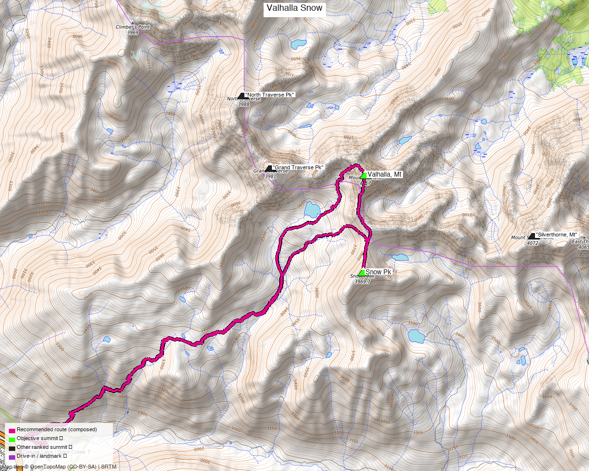
Note: the recommended route was distilled from 9 recorded GPS tracks of real trips (14ers.com · ListsofJohn · peakbagger) — all layered on the interactive CalTopo research map.
Peaks covered
Two Gore summits reached from the same steep drainage. Snow Peak's North Ridge is the harder of the two — climb13ers calls it "mostly Class 2 hike with some brief Class 3 scrambling on large blocks," with minimal exposure and easy routefinding. Valhalla's West Ridge is Class 2+ but with moderate routefinding, which is the real thinking required on the day.
| Peak | Elev | Class (route) | Solo from TH (climb13ers) | peak_db |
|---|---|---|---|---|
| "Mt Valhalla" | 13,202' | 2+ (West Ridge) | 12.25 mi / 5,225' | 624 |
| "Snow Pk" | 13,039' | 3 (North Ridge) | 10.8 mi / 4,350' | 793 |
Both sit in the Eagles Nest Wilderness (White River NF), Vail East / Willow Lakes quads — no permits or fees, standard wilderness rules. LiDAR added 22 ft to Valhalla. Snow Peak was formerly listed as "UN 13039".
Getting there — Gore Creek / Deluge Lake (East Vail)
Drive from Boulder: ~2h 41m via Google Maps (origin: 1162 Peakview Circle) — I-70 W to East Vail (exit 180), then the frontage road / Bighorn Rd east to the Gore Creek / Deluge Lake trailhead at the end of Gore Creek Road. 115 mi.
| Trailhead — Deluge Lake / Gore Creek | ~39.62752,-106.27753, ~8,700'. All paved, any passenger car (climb13ers confirms). Forest Service lot, no fee, at the road's end past the Gore Creek Campground. |
| Trail | Deluge Lake Trail — it splits left off the Gore Creek Trail shortly in and climbs hard: climb13ers calls it a "steep trail hike of over 4 miles one way before beginning the main ascent." Deluge Lake sits at ~11,700'. |
| Neighbors from the same TH | Mt Silverthorne (own report), plus Grand Traverse and North Traverse (already climbed). |
Route — Deluge Lake Trail, Valhalla first, then Snow Peak (Class 3)
~12.5 mi · ~5,427 ft round trip. The recommended line is stitched from three recorded segments — each leg is a real party's GPS track, not an interpolation — and takes the two objectives only. Every recorded both-peaks party also tagged Grand Traverse Pk on the same outing (you've already climbed it), which is why their tracks run 15–17 mi; leaving that third summit out saves roughly 3 mi and 1,500 ft (see Other considerations):
- Up: Deluge Lake Trail → Mt Valhalla's West Ridge — 6.2 mi (recorded 14ers track). Over 4 mi of relentlessly steep, well-defined trail up the drainage toward Deluge Lake (~11,700'), then off-trail onto the West Ridge (Class 2+): boulder talus and rubble to the 13,202' summit. Exposure is minimal, but routefinding is moderate — the ridge has to be read rather than followed. This leg is the bulk of the day's work.
- Across: Valhalla → Snow Peak — 1.15 mi (recorded peakbagger track). South along the connecting ridge past Snow Pass, then up Snow Peak's North Ridge (Class 3, the crux) — the day's only real scrambling: brief Class 3 moves on large stacked blocks, exposure minimal, routefinding easy.
- Down: Snow Peak → trailhead — 5.1 mi (recorded 14ers track). Off the north ridge back toward Deluge Lake and out the trail. climb13ers notes it's "helpful to find the trail to Snow Pass from the lake, otherwise the scree ascent to the pass could be frustrating" — worth knowing in this direction too.
Why Valhalla first: it's the higher summit and the one with the route-finding, so it gets done while you're fresh; Snow Peak's short scramble then sits on the way out. This is also the order both recorded both-peaks parties used. From Deluge Lake, Snow Peak alone is only 0.90 mi / 1,300' one-way, which is why adding it to a Valhalla day is cheap.
Gear & season
- Best window: mid-July through September. The Gores hold snow late and this is a north-facing basin; climb13ers recommends an ice axe for Snow Peak, which is worth taking seriously into early July.
- Gear: helmet for the Class 3 blocks on Snow Peak's north ridge. No rope needed on either standard line. Poles earn their keep on 4+ mi of steep trail in each direction.
- Watch the trail, not the summits, for the hard part — Snow Peak's scramble is brief; the day is defined by ~5,427 ft of gain, most of it on that steep approach trail.
- Weather strategy: 4 mi of trail before any exposure means an early start; both summits and the connecting ridge are fully above treeline.
- Cell: East Vail is close, but the Deluge basin is walled off. Carry an InReach.
Other considerations
Don't be misled by the recorded mileage — or by climb13ers' numbers. Every recorded both-peaks track here is really a three-peak day that also walks over Grand Traverse Pk (the August track passes 5 ft from its summit). Since you've already climbed Grand Traverse, the recommended route deliberately leaves it out, which is why it reads 12.5 mi / 5,427 ft against those parties' 15–17 mi. Note too that climb13ers' "Valhalla 12.25 mi / 5,225' RT" is itself labelled "CLIMBED WITH 'GRAND TRAVERSE PEAK'" — it is not a Valhalla-alone figure, so it's the wrong yardstick for this pair. Terrain arithmetic backs the number: TH 8,700' → Valhalla 13,202' is 4,502 ft net, plus roughly 900 ft re-ascent off the connecting col for Snow Peak.
If you want the three-peak day anyway, the tracks are on the map. Adding Grand Traverse (13,063', already climbed) back in costs about 3 mi and 1,500 ft — that is the long day-hike climb13ers describes for "strong climbers," and two recorded parties did exactly it. The August 2024 recording is the one to follow for that variant.
Two of the five swept tracks are unsuitable regardless. The October both-peaks recording starts in the East Vail residential streets — Nugget Lane / Columbine Drive, no trailhead there at all — so that party walked a mile of neighborhood before reaching the trail (16.8 mi total), and it's shoulder-season besides. A third is a November 2025 winter outing on Snow Peak only.
Deluge Lake is a basecamp if you'd rather not day-trip it. climb13ers uses a lake camp to collect Snow Peak with Mt Silverthorne (Willow BM), and mentions a backpack that adds Grand Traverse. As a day trip — your preference — this is one 12.5 mi outing and Silverthorne is another; as a backpack, the two reports merge.
This is a steep day, not a technical one. ~5,427 ft over 12.5 mi, with a single short Class 3 section. The gate here is the approach trail's grade, not the scrambling.
Trip reports & GPX (all three sources)
Sources confirmed logged in: 14ers.com ("Basin"), listsofjohn.com ("letsgocu"), peakbagger.com ("Kyle Knutson"). Both peaks' libraries were swept across all three sources and deduped, plus the full OSM trail network (52 mapped ways incl. the Deluge Lake, Gore Creek, Bighorn and Gore Lake trails) — all layered on the CalTopo map.
- 14ers.com: peak pages "Mount Valhalla" (10231), "Snow Peak" (10248) — 2 GPX-library tracks.
- listsofjohn.com: Valhalla, Mt (624), Snow Pk (793) — 10 trip reports, text only (no downloadable GPX); LoJ grades both 2+.
- peakbagger.com: Mt Valhalla pid 33071, Snow Peak pid 33072 — 3 ascent GPX pulled, including the August both-peaks day the route is built from.
- climb13ers.com: Mt. Valhalla West Ridge (Class 2+) · Snow Peak North Ridge (Class 3) — route, class and trailhead beta.
Sources checked: 14ers.com ✓ (logged in, "Basin") · listsofjohn.com ✓ (logged in, "letsgocu") · peakbagger.com ✓ (logged in, "Kyle Knutson")