Savage Pk + PT 13,002 (Holy Cross Wilderness, Sawatch)
Other climbers: Emily Sharpe — not yet · Shawn D Keil — 1 of 2 (Savage Peak)
At a glance — recommended day
14.3 mi · 5,433 ft gain · Class 3 · 2 peaks · ~4.22 h drive
NOAA weather link: Savage Pk / PT 13,002 (Holy Cross Wilderness) Weather
Drive from Boulder: ~4h 15m via Google Maps
CalTopo research map: https://caltopo.com/m/P11EBDB
Researched: 2026-08-13
Status in Peak Checklist: both unclimbed. Two ranked Sawatch 13ers on opposite ends of a high ridge in the Holy Cross Wilderness — Savage Pk (13,135') and PT 13,002 — sitting above the beautiful Missouri Lakes basin north of Leadville. The linkup from Fancy Creek TH is a counterclockwise loop: head into the basin, swing west to PT 13,002 first, traverse east along the high ridge to Savage Pk, then loop back through the upper basin. The headline class is 3, driven by a short Class 3 notch approach on PT 13,002. Both peaks are ~4.25 h from Boulder — a far-from-home objective well worth the drive for both in a single long day.
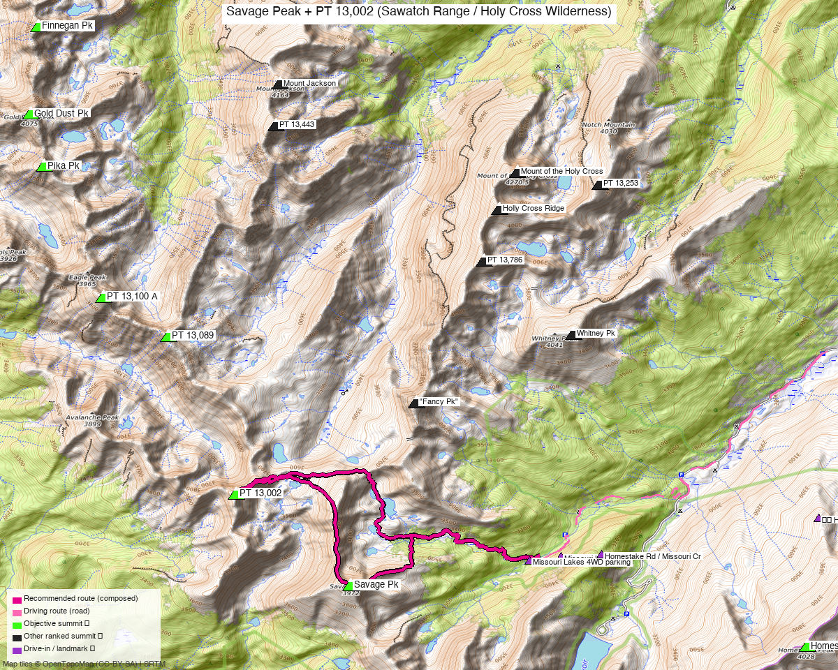
Note: the recommended route was distilled from 7 recorded GPS tracks of real trips (14ers.com · ListsofJohn · peakbagger) — all layered on the interactive CalTopo research map.
Peaks covered
Both peaks lie in the Holy Cross Wilderness, White River NF — no permits or fees for a day hike. Savage Pk has a clean north ridge approach from the Missouri Lakes basin (Class 2); PT 13,002 adds a committed Class 3 notch crux above its highest approach lake.
| Peak | Elev | Class | CO rank | LoJ | Status |
|---|---|---|---|---|---|
| Savage Pk | 13,135' | 2 (solo) | 539 | 674 | unclimbed |
| PT 13,002 | 13,002' | 3 | 636 | 839 | unclimbed |
Linkup headline class: 3 — the Class 3 notch on PT 13,002 is the crux of the combined day. Savage Pk by itself from this trailhead is a clean Class 2 loop (~8 mi, see Other considerations).
Recommended route — counterclockwise loop ⭐
14.3 mi · 5,433 ft gain · Class 3 — a counterclockwise loop from Fancy Creek TH into the Missouri Lakes basin. The eagle-county-climb track (forensically verified recording-like, Kyle-admitted 2026-08-12) is the only track covering both objectives from this trailhead and is the basis for the recommended route.
The loop follows the Missouri Lakes trail (~2.5 mi of well-worn trail through the basin, with 3 stream crossings — 2 with good bridges, 1 log crossing). A bypass trail skirts the massive 2019 avalanche debris at ~2–2.5 mi; the bypass is well-established and passable with a pack. Above the basin, the route gains the high plateau between the two summits.
Direction: PT 13,002 first (~40% through the loop, ~5.7 mi from TH), then Savage Pk (~73% through, ~10.4 mi), then back to TH. This counterclockwise direction visits the harder objective (Class 3) while legs are fresh.
Composed-difficulty note: the linkup raises the headline class vs. Savage Pk solo (Class 2). The easier solo option is listed under Other considerations.
Route sequence
- Fancy Creek TH (~9,970') — head south on the Missouri Lakes trail; the well-worn path traverses through forest, passes through a brief slot-canyon gorge section, and emerges into open meadows
- Avalanche bypass (~2–2.5 mi) — when the trail hits 2019 debris, take the established bypass trail right (uphill), skirt the damage on a higher contour, and rejoin the original trail; you'll still climb over a few logs but it goes easily
- First lake area (~11,420') — continue past the Missouri Lakes, now above treeline; the basin opens up with views of both objectives
- PT 13,002 (13,002') — from the upper basin, approach from the east side via a steep flower-strewn slope to a bench, then angle right up low tundra/talus to the notch; the last few feet to gain the notch is the Class 3 crux (brief, moderate exposure); above the notch, traverse Class 2+ ledges SW to the rocky summit — views of Lime Creek drainage, Strawberry Lakes, and Ribbed Peak
- Traverse ridge to Savage Pk — follow the high connecting ridge east/southeast, dropping to the ~12,337' saddle then reascending ~665' to Savage Pk
- Savage Pk (13,135') — gain the north ridge just below 12,600' and walk south to the large tundra-and-rock summit with register; views of the full Missouri Lakes basin and Whitney Pk to the north
- Return via east ridge and basin — descend the east ridge to where it levels above ~11,700' and drop north through forest on game trails to regain the Missouri Lakes trail; 2 mi back to TH
Getting there — Fancy Creek Trailhead (9,970')
Drive from Boulder: ~4h 15m via Google Maps (origin: 1162 Peakview Circle) — I-70 W to Minturn, south on CO24 over Tennessee Pass toward Leadville; watch for the Homestake Reservoir / FR703 turnoff at the S-curve (sign visible from both directions).
| Drive from Boulder | ~4h 15m via Google Maps |
| Trailhead | Fancy Creek TH (= Missouri Lakes TH), 39.39012, -106.47064, ~9,970' |
| Road | CO24 at the S-curve between Minturn and Leadville → FR703 west (loses some elevation on initial switchbacks; info kiosk at 0.3 mi, primitive campsites along road). Continue 6.7 mi on FR703 to Gold Park CG (12 sites, vault toilet, fee ~$21/night). Do NOT turn onto FR759 (Holy Cross City 4WD road — strictly 4WD). At the signed intersection ~1 mi past Gold Park CG, turn right onto FR704. Drive 2.1 mi to the trailhead — the first mile has switchbacks. Entire drive passable for passenger cars of most types; some sections may be washboarded. Vault toilet at TH. |
| Land | Holy Cross Wilderness, White River NF. No permit or day-use fee. |
Gear & season
- Best window: July–September, once the Missouri Lakes trail clears. The most recent summer recording (trk_pb_3, 2026-07) and the validated eagle-county-climb confirm good conditions from mid-July. 2 summer-dated source tracks (Aug) confirm both objectives accessed by then.
- Ice axe / microspikes: Recommended early season for PT 13,002 — the notch approach is east-facing and holds snow; climb13ers explicitly recommends an ice axe for early-season conditions on that peak.
- Terrain: Mostly Class 2 tundra, talus, and embedded rock; well-worn Missouri Lakes trail for the first 2–3 miles. The Class 3 notch on PT 13,002 is brief (last few feet to gain the notch) with moderate short-section exposure above; the rock is generally solid with adequate ledges.
- Avalanche debris: The 2019 avalanche left a quarter-mile swath of downed trees across the Missouri Lakes trail at ~2–2.5 mi. A bypass trail is now well-established; by 2024 it's a routine detour. The east-ridge descent from Savage Pk also passes near the debris — avoid descending directly through it.
- Crowds: The Missouri Lakes basin is very popular on summer weekends — expect company on the trail, especially near the lakes.
- Afternoon storms: typical Colorado pattern — start early, target both summits before noon.
- Cell: limited to none in the Missouri Creek drainage. Carry an InReach.
Other considerations
Savage Pk solo (Class 2, ~8 mi RT): If you want just Savage Pk without the Class 3 terrain on PT 13,002, the North Ridge Route is a clean Class 2 loop entirely from this same trailhead — roughly 8 mi / ~3,115 ft, back for a late lunch. The Missouri Lakes basin approach is the same; head directly to the first lake, gain the north ridge via the grassy gully/slope, and walk south to the summit. No technical moves, no exposure.
PT 13,002 solo via western approach (Eagle Lake TH): climb13ers' canonical Carter Creek route to PT 13,002 approaches from Basalt via Savage Lakes/Carter Creek TH (~11.6 mi / 4,380 ft RT, Class 3). Note 03/2024: a blow-down of trees has made the Carter Creek trail "nearly impassable" all the way to Carter Lake; best current approach from that side is to pack in via Missouri Lakes to Blodgett Lake and into the upper Carter Creek drainage, or use the Eagle Lake TH on the western side. Three recorded tracks (trk_loj_17985, trk_pb_2, trk_pb_1) document the western Eagle Lake TH approach (~14–18 mi RT, Class 3) — but that TH is ~4h 55m from Boulder (40 min further than Fancy Creek TH). For Kyle, the Fancy Creek linkup is clearly the right call: both peaks in one day, from the closer trailhead.
Neighbors: find_peaks_near.py found no other unclimbed peaks sharing the Fancy Creek approach infrastructure. Nearby unclimbed peaks (PT 13,089 "Ribbed Peak" at 4.2 mi, PT 13,100 A at 5.2 mi, Homestake Pk at 5.7 mi) all use different trailheads — see their dedicated reports. Drive time (~4.25 h) meets the far-from-home threshold, reinforcing the single-trip linkup strategy already chosen.
Trip reports & GPX (all three sources)
Sources confirmed logged in: 14ers.com ("Basin"), listsofjohn.com ("letsgocu"), peakbagger.com ("Kyle Knutson"). Both peaks' full GPX libraries swept and deduped across all three sources, plus the mapped OSM trail network in the bbox — all layered on the research map.
-
14ers.com: 7 tracks found across both peaks' libraries (14ers pids 10810 and 10872) — all 7 were cross-source duplicates of LoJ or peakbagger tracks; no unique 14ers-only recordings.
-
listsofjohn.com: 7 tracks found across Savage Pk (674) and PT 13,002 (839): trk_loj_16374 (2024-08, 15.6 mi, Savage Pk via Fancy Creek, valid summer); trk_loj_2804 (2016-10, 12.8 mi, Savage Pk — October shoulder, rejected for recipe); trk_loj_17985 (2025-08, 18.1 mi, PT 13,002 from Eagle Lake TH); trk_loj_950 (14.5 mi, PT 13,002 from Carter Creek, recorded as one-way artifact — not usable RT). Five others were cross-source dupes.
-
peakbagger.com: 5 tracks found (pids verified: Savage Pk pid 15199, PT 13,002 pid 113688 ["Peak 13001"]): trk_pb_3 (2026-07, 14.1 mi, Savage Pk from Fancy Creek — most recent summer track); trk_pb_1 (13.3 mi, PT 13,002 from Carter Creek / Savage Lakes TH — rejected: no OSM TH/parking within 1 mi); trk_pb_2 (2025-08, 15.2 mi, PT 13,002 from Eagle Lake TH). Three were cross-source dupes.
-
CalTopo-submitted (eagle-county-climb): The only track covering BOTH peaks from Fancy Creek TH. Timestamps and elevations stripped (likely by conversion tool). track_forensics.py RECORDING-LIKE (362 dwell clusters, human-pace spacing, 10,579 pts / 14.3 mi). Reviewed and admitted by Kyle 2026-08-12; see
gpx/savage_peak/deviations.ymlandgpx/savage_peak/peaks.yml validated_tracks.
Tracks rejected from recipe: - All CalTopo drawn lines except eagle-county-climb (⚠ DRAWN LINE, no timestamps) - trk_loj_2804: October shoulder season - trk_loj_950: one-way data artifact - trk_pb_1: Savage Lakes TH cluster — no OSM TH/parking within 1 mi (per find_osm_trailheads; rejected per trailhead rule) - trk_loj_16374, trk_pb_3: valid Savage Pk–only tracks; good for solo, not the linkup
Sources checked: 14ers.com ✓ (logged in, "Basin") · listsofjohn.com ✓ (logged in, "letsgocu") · peakbagger.com ✓ (logged in, "Kyle Knutson")