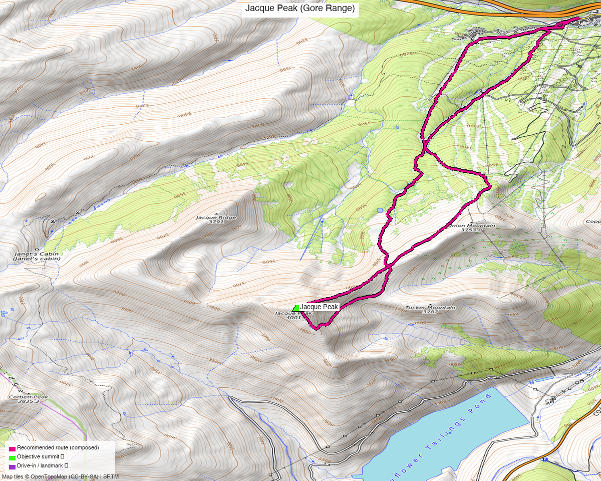
Jacque Peak (Gore Range)
At a glance — recommended day
10.3 mi · 3,473 ft gain · Class 2 · 1 peak · ~1.7 h drive
✅ Climbed 2026-06-06 — actual: 10.8 mi / 3,674 ft (loop)
Kyle's recorded outing (fast-hike up, jog down): 10.8 mi · 3,674 ft, done as a loop — right in line with the ~10.2 mi / ~3,500 ft recommended Copper loop below (he started ~0.7 mi from the assumed Woodward-base TH). GPS track on file (GPS Tracks/20260606_Summit_County…_actual.gpx).
Researched: 2026-05-28
NOAA weather link: Jacque Peak Weather
CalTopo research map: https://caltopo.com/m/R2NF0S2
Status in DB: climbed (2026-06-06). Cluster status: - ✗ No same-drainage unclimbed ranked 13ers — Bartlett Mtn (5.74 mi) is the only nearby unclimbed ranked peak, but it sits on the opposite side of Fremont Pass / Climax Mine and is a different drive entirely - ✓ Done nearby (Tenmile/Mosquito group): Pacific (4.49 mi), Crystal A (4.62), Atlantic (4.74), PT 13,207 (4.89), Fletcher (5.08), Peak 10 (5.08), Wheeler (6.08), Quandary (6.25), Clinton (6.51), N Star (6.74) - Effectively a standalone day — combinations with Tucker/Union/Copper Mtn (12,xxx's) are common but those are all sub-13k and don't count as ranked combos

Note: the recommended route was distilled from 12 recorded GPS tracks of real trips (recorded trips) — all layered on the interactive CalTopo research map.
Other climbers: Emily Sharpe — not yet · Shawn D Keil — ✓ climbed
The peak
| Jacque Peak | |
|---|---|
| Elevation | 13,212' (LiDAR; map 13,205') |
| Lat / Lon | 39.45485, −106.19713 |
| 14ers.com peak page | https://www.14ers.com/peaks/10229/13er-jacque-peak |
| listsofjohn.com | https://listsofjohn.com/peak/603 |
| peakbagger.com | https://peakbagger.com/peak.aspx?pid=5781 |
| Range / NF | Gore Range / White River NF (NOT in Eagles Nest Wilderness — sits just outside) |
| Class (standard) | 2 |
| Peak DB id | 603 |
| CO Rank | 480 |
| CO Prominence Rank | 58 (Rise 2,296' LiDAR — high prominence!) |
| Quad | Copper Mountain |
| County | Summit |
Recommended route — From Copper Mountain Resort base (Woodward Express area) ⭐
The most common modern approach. Up through Copper ski terrain, over Union Mountain (12,313'), then a long ridge walk + boulder hop to Jacque's summit.
⚠️ During active ski season (roughly mid-November through early May): hiking through Copper ski terrain requires mandatory annual uphill registration + visible armband. Free for Copper Season Pass or Ikon Pass holders — but you must still register online and pick up the armband at the Mammut Store in Center Village before going. Route 1 (Aerie/PHQ, the relevant approach) is mornings only, 5am–8:30am, and you must descend the same route. Details: Copper uphill access page.
Once the ski lifts close for the season (typically early May), the terrain reverts to standard USFS access — no registration, no restrictions, hike freely.
| Route | Stats (Alex Gaab PB 8/8/2025) |
|---|---|
| Difficulty | Class 2 (one short section of "actual climbing" per Gaab; otherwise long talus/boulder fields) |
| Distance | 10.2 mi RT |
| Gain | 3,500' |
| Time | ~3 h (Gaab — fast) to ~5.5 h (typical) |
| Start elev | ~9,712' (Copper base village) |
| Aspect | East/SE up Copper Bowl, then west ridge to summit |
Route sequence (per Gaab 8/8/2025 + Stratmoen 8/30/2021)
- Park at Copper Mountain Resort (I-70 exit 195) — base village free lots in summer
- Hike up under the Woodward Express lift (Stratmoen's start) — easy ski-run grading
- Pass over Union Mountain summit (12,313') — gentle ridge
- Continue west on the broad ridge above Copper Bowl
- Long talus/boulder hop — Gaab notes "long scrambles across rock fields, and a few actual climbing spots, but never anything truly dangerous, rock was stable"
- False summit (Stratmoen flags this) before the true summit
- Descend the same way OR (Gaab's trick) drop down the Copper ski runs to shortcut — saves mileage
Alternates
B. Graveline Gulch from CO 91 (older / passholder-skip option) - Lochary 4/10/2026 + avalletta 11/3/2012: 7.5 mi RT, 3,700–4,000', ~5.5h - Park on the east side of CO 91 across from the closed mine (avoid mining property) - Walk down the road a few hundred yards north, cross to the west side, then bushwhack up Graveline Gulch (Lochary: "nice game trail on the climbers right most of the way") - Open forest, easy travel; emerges on the east slopes of Tucker Mtn → ridge west to Jacque - Used to access Copper + Tucker + Union as the standard "Copper trifecta" combo - Trade-offs: shorter mileage, no ski area, but requires reading the closed-mine boundary carefully
C. Mayflower Gulch (winter, non-passholder) - Westra 3/16/2025: 9.1 mi, 2,249', 7h14 from 10,963' TH - ⚠️ Westra explicitly warns: crossed the Mayflower Tailings Pond, "I do not recommend as I learned it is trespassing." Find a legal alternative. - Janet's cabin (10th Mtn Hut System) is the legal winter base if you have reservations
D. Vail Pass rest area / Ptarmigan Pass ridge traverse (mega ridge day) - Andrew Wahr 10/9/2025: 11-peak traverse including Sugarloaf, Elk Mtn, Pearl Pk, Ptarmigan Hill — none ranked 13ers - Not relevant for a single-peak Jacque day; reference for sub-13k peakbagging if interested
E. Searle Gulch / Searle Pass — Stratmoen notes this route is no longer viable due to current mining operations gating the access road that was open in 1996. Don't try it.
Getting there — Copper Mountain Resort base
| Location | I-70 Exit 195 (Copper Mountain), summit county. ~75 mi west of Boulder |
| Drive from Boulder | 1h 42m via Google Maps (origin: 1162 Peakview Circle) |
| Vehicle | Anything — paved to base village |
| Start elev | ~9,712' (base village) |
| Parking | Free in summer. In ski season: interior lots free before 8:30am and after 2pm; hangtag (pick up at Mammut Store when getting your uphill armband) required during daytime. |
| Facilities | Full village amenities (food, restrooms, water) in season |
| Trail start | Walk up under Woodward Express lift area (look for the lift access road) |
Alternate TH — CO 91 / Graveline Gulch pullout
| Location | East side of CO 91, ~1.5 mi south of Copper exit, across from closed mine |
| Drive from Boulder | ~1h 45m via Google Maps (similar to Copper) |
| Vehicle | Anything — pull off paved highway |
| Start elev | ~10,500' |
| Parking | Side of CO 91 — "no signs where I parked" (avalletta). Mine has aggressive No Parking signs by concrete barriers — park before them. |
| Caveat | Walk a few hundred yards north on CO 91 before crossing west to avoid mine property |
| Facilities | None |
Permits / access:
- White River National Forest — no permits, no fees
- NOT in Eagles Nest Wilderness (peak sits on the boundary; standard route from Copper is outside)
- Copper Mountain Resort base parking: free in summer. In ski season, interior lots are free before 8:30am and after 2pm (hangtag from Mammut Store required during the day — you get it when picking up your uphill armband)
- ⚠️ CO 91 / Graveline approach: be careful with closed mine boundary — Lochary, avalletta, and Stratmoen all flag No Parking enforcement on the concrete-barrier side
Gear & season
- Best window: late June through October. Talus crux is unpleasant under snow but doable
- Summer storms: standard Colorado afternoon storm risk on the exposed west ridge — early start needed. Stratmoen got smoke obscuring the views in August (wildfire season factor)
- Winter: Multiple winter ascents in PB record (Dec/Feb/March). Stratmoen's late-Aug climb mentions smoky views. jacolc winter 2017 ascent took 9h46 vs 5.5h summer
- Lift-served winter (Copper uphill access): hiking through Copper ski terrain during ski season requires mandatory annual registration + visible armband. Free for Copper Season Pass or Ikon Pass holders — but you must still register online and pick up the armband at the Mammut Store in Center Village ($5 for a new armband, free insert). Non-pass holders can purchase an Uphill Access Pass separately. Must use designated routes only — Route 1 (Aerie/PHQ, 2,210 ft) runs mornings only, 5am–8:30am, and you must descend the same route. See Copper uphill access page. Otherwise Graveline Gulch (CO 91) is the clean ski-area-free option for anyone.
- Wind: typical Gore Range exposure on the west ridge
- Cell coverage: 14ers.com community DB not yet queried — typically 0 reports for 13ers without route descriptions. Geographic reasoning: TH (Copper base village) strong signal — full resort coverage; approach (Copper Bowl) strong on the east-facing ski terrain; west ridge / summit likely good — LOS to I-70 corridor towers (Vail, Frisco) and Copper village. Carry InReach but coverage should be solid for the Copper-side approach. Graveline Gulch start is more drainage-shadowed.
Trip reports
14ers.com (15 reports)
| Date | Source | Notes |
|---|---|---|
| 7/10/2025 | mountain_guy TR 23116 | "Jacque Peak and Friends — A Day in the Southern Gore Range" — multi-peak |
| 7/10/2024 | Peaks4Days TR 22610 | "Jacque Peak Loop" — solo loop |
| 7/10/2024 | WildWanderer TR 22609 | "From Copper Mountain Ski Area" — Jacque + Union (standard modern route) |
| 9/4/2022 | d_baker TR 21988 | "My Summer Vacation" — Fancy + Pk Three + Kendall + Jacque + 3 PTs + T 5 (big day) |
| 7/21/2019 | supranihilest TR 19639 | "Jacquerebleu" — Jacque + Copper trifecta |
| 7/1/2017 | rajz06 TR 17861 | "Just Between Jacque et Moi" — Jacque + Copper trifecta |
| 9/18/2016 | WillRobnett TR 17481 | "Gore Range 13ers" — 10-peak mega-traverse including ranked peaks |
| 6/29/2016 | dillonsarnelli TR 17183 | "Jacque to Music, and Some Extra Credit" — Jacque + Music + Savage |
| 11/3/2012 | piper14er TR 13115 | "Jacque-ularity" — Copper trifecta |
| 5/26/2012 | milan TR 11905 | "Mosquito Memorial" — Jacque + Tweto + Mosquito + Pennsylvania + W Buffalo (3 ranked 13er+ partners!) |
| 4/22/2012 | skiingrock TR 11674 | "Duffy's Rage" — solo ski |
| 7/30/2011 | BobbyFinn TR 10818 | "Jacque the Long Way" — solo |
| 7/22/2010 | kaiman TR 8587 | "Jacque Peak via Copper Creek" — solo |
| 11/11/2007 | stevevets689 TR 3984 | "Tour de Tucker Gulch" — solo |
| pre-2007 | TR 2986 | "Jacque Peak Take 2: A Postcard Day" |
listsofjohn.com (6 reports — key stats only)
| Date | Climber | Stats | GPX | Style |
|---|---|---|---|---|
| 2025-10-09 | Andrew Wahr TR 29420 | 11-peak Vail Pass ridge traverse | 18285 | Mega ridge day, sub-13k partners only |
| 2024-07-30 | josephnephi TR 27037 | Jacque + Copper + Tucker + Union | 16251 | Copper trifecta, sub-13k partners |
| 2021-08-30 | PaulStratmoen TR 20181 | Jacque + Union, base of Copper under Woodward Express | 11112 | Ski-area route |
| 2017-12-28 | jacolc TR 27210 | 8.2 mi / 4k' / 9h46 winter | 16401 | Copper trifecta winter |
| 2012-11-03 | avalletta TR 1721 | 7.5 mi / 3,700' / 5.5h Graveline Gulch | — | CO 91 start, sub-13k partners |
| 2008-11-01 | RyanKowalski TR 1548 | 7.5 mi / 4,000' Jacque + Copper | — | CO 91 start |
peakbagger.com (193 members ascended; 8 recent ascents detailed)
| Date | Climber | Stats | Trip / notes |
|---|---|---|---|
| 2026-04-10 | Michael Lochary aid 3161419 | (no stats) | Copper + Union + Jacque + Tuckers. "Graveline Gulch has a nice game trail on the climbers right most of the way" |
| 2025-08-23 | Lee Newton aid 2956076 | 3,422' / 9.8 mi / 5h29 | Single Jacque, 9,790' TH (~Copper base) |
| 2025-08-08 | Alex Gaab aid 2934720 | 3,500' / 10.2 mi / 3h | Union → Jacque. Copper Mountain start. "Long scrambles, a few actual climbing spots, but never anything truly dangerous, rock was stable" |
| 2025-06-22 | Jack Murdoch aid 2879347 | (no stats, ski poles) | — |
| 2025-03-16 | Xander Westra aid 2784737 | 2,249' / 9.1 mi / 7h14 from 10,963' TH | Mayflower Gulch start (avoids Copper ski area for non-passholders) — ⚠️ crossed Mayflower Tailings Pond, "do not recommend as I learned it is trespassing." Find legal alternative. |
.gpx files (to be downloaded to gpx/jacque_peak/)
LoJ GPX library (all available — log into LoJ to download):
- jacque_18285.gpx — Wahr 11-peak Vail Pass ridge traverse (reference for the mega-ridge option)
- jacque_16251.gpx — josephnephi Copper trifecta 7/30/2024
- jacque_11112.gpx — Stratmoen Jacque + Union from Woodward Express 8/30/2021
- jacque_16401.gpx — jacolc winter Copper trifecta 12/28/2017
14ers.com GPX library: check https://www.14ers.com/php14ers/gpxlib_locator.php?peakid=10229 for additional tracks tied to the 15 trip reports
Generated (to build):
- jacque_peak_summit_TH.gpx — Jacque summit + Copper Mtn base TH + CO 91 / Graveline pullout
- jacque_peak_route_recommended.gpx — extract from Stratmoen 11112 (Jacque + Union via Woodward Express)
Sources checked: 14ers.com · listsofjohn.com · peakbagger.com