White Rock Mountain + White Benchmark — Queen Basin from Copper Creek (Class 3)
Other climbers: Emily Sharpe — not yet · Shawn D Keil — ✓ all
At a glance — recommended day
10.5 mi · 4,299 ft gain · Class 3 · 2 peaks · ~6.39 h drive
NOAA weather link: Queen Basin Weather
CalTopo research map: https://caltopo.com/m/022D0DG
Researched: 2026-08-03
Status in Peak Checklist: both unclimbed.
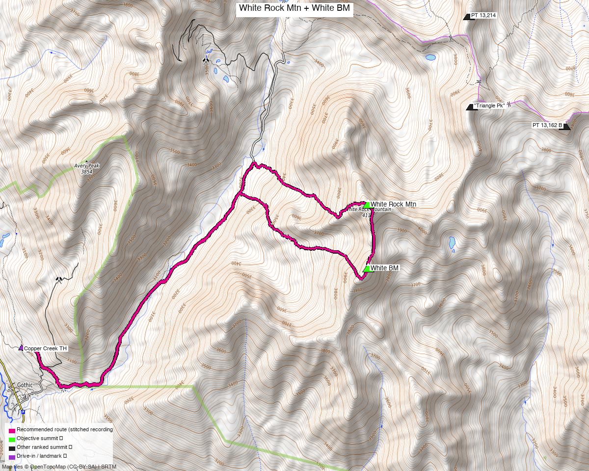
Note: the recommended route was distilled from 15 recorded GPS tracks of real trips (14ers.com · ListsofJohn) — all layered on the interactive CalTopo research map.
Peaks covered
| Peak | Elev | Class | CO rank | Rise |
|---|---|---|---|---|
| White Rock Mountain | 13,523' | 2 | 242 | 736' |
| White Benchmark | 13,411' | 2+ | 316 | 367' |
Gunnison County, Elk Mountains — the two ranked summits ringing Queen Basin, above Copper Creek northeast of Gothic. They are 0.51 miles apart, which is the entire argument for doing them together.
The recommended route — 10.5 mi / 4,299 ft
From the Copper Creek TH at Upper Judd Falls parking (9,821'):
| Leg | Distance | On trail | Source |
|---|---|---|---|
| TH → White Rock Mountain | 4.95 mi | 57% | trk_14ers_3 |
| White Rock → White Benchmark | 0.61 mi | — | trk_14ers_3 |
| White Benchmark → TH | 4.93 mi | 48% | trk_14ers_3 |
One recording is genuinely the best whole day here. The route composer evaluated every
combination across 15 tracks and chose the same track — trk_14ers_3 — for all three legs. That
is unusual on this site and it means there is no stitching to explain: the line is one party's
actual day, followed verbatim.
(The composer did propose walking it backwards, White BM first, on a marginal cost difference. The direction is pinned forward instead, because that is the way both the recording and the written beta go.)
The shape is an out-and-back with a summit traverse at the top — the two long legs share about 62% of their ground, and the 0.61 mi in the middle is the traverse across Queen Basin between the summits. Start and finish are 42 ft apart.
The sequence, from the beta
- Take the Copper Creek Trail from the upper trailhead.
- Leave the trail about a mile past the creek crossing and climb an overgrown avalanche path — "We found it easiest to stay to the climbers right, near the forest."
- Enter the forest near the top and contour around the toe of White Rock's west ridge.
- Up a boulder-filled basin to a steep, grassy ramp onto the ridge.
- The ridge to White Rock: "C2+ and felt much longer than it looked. It becomes increasingly loose in the final few hundred feet to the summit."
- Reverse and traverse across Queen Basin to White Benchmark's south ridge — "a mix of animal and miners trails to reach the ridge."
- White BM's south ridge is the crux: "C2+/C3 to the summit on questionable rock."
- Reverse to the trail and out.
Class 3 is the headline on the strength of that south ridge plus Furthermore's "Max difficulty: Minor class 3" for the same pair from the same trailhead. Both LoJ peak pages say 2 / 2+, which under-states the last few hundred feet on White BM.
Getting there — Copper Creek / Judd Falls
| Drive from Boulder | ~6h 25m via Google Maps (~256 mi) — Crested Butte, then Gothic Road to Gothic. |
| Trailhead | Upper Judd Falls parking, 38.96413, −106.98840, 9,821'. OSM maps this lot; the tracks start 0.01 mi away. |
| Road | "Easy 4WD / mid-clearance recommended to drive to the upper TH" (whileyh, Sept 2025). Furthermore called the approach "rough 2WD, high clearance recommended." Vault toilets are at the LOWER lot (Lower Judd Falls, 0.31 mi down at ~9,590') — stopping there costs roughly half a mile each way. |
| Land | Gunnison NF. The access sweep found the Rocky Mountain Biological Laboratory (access=private) at Gothic — you drive past it, and it does not touch the route — plus the Crested Butte ski areas, well away. |
Gear & season
- Best window: July through September. The approach climbs an avalanche path, so it holds snow and deadfall; the recorded pool runs June to September with the cleanest lines in July.
- Terrain: Class 2 trail and grass to the ridges, then C2+ on White Rock and C2+/C3 on White BM's south ridge, on rock two separate parties call "questionable."
- Helmet: yes, for the final few hundred feet on both.
- Route-finding: the two decision points are where you leave the Copper Creek Trail (~1 mi past the creek crossing) and staying climber's right up the avalanche path. Above that it is game trails and miners' trails.
Other considerations
There is a second trailhead, and it is just as good. Three recorded tracks reach both peaks
from the Brush Creek side (~38.9445, −106.8876, 10,040'), and trk_14ers_5 does the pair in
10.4 mi — essentially identical to this route. Drive time is the same to the foot
(~6h 08m to either, 51 min apart by road). Copper Creek is recommended here only because the
beta names it and OSM maps the parking; if Brush Creek is more convenient on the day, it costs
you nothing.
A genuine loop exists, via Deer Creek. whileyh's 2025 line connects the Judd Falls/Copper Creek Trail with the Deer Creek Trail, joined by "a little over a mile of 2wd gravel road that goes through the town of Gothic." Worth knowing: the Deer Creek approach "was recently regraded September 2025 and is now 2wd/low clearance accessible" — but it has a couple of gates to go through and close behind you, and starting the loop at the lower Copper Creek lot means "a few hundred feet of gain to end the loop with uphill."
Teocalli Mountain is 2.7 miles away and is its own report — it is climbed from the Brush Creek side and is a Class 1+ walk-up, a completely different day. The two make an obvious weekend from one Crested Butte base.
"Triangle Peak" (13,405', unclimbed) sits between them, 1.25 mi from White Rock. It appears in both of the big linkup trip reports here — John Kirk took six peaks in a day and josephnephi took seven, both including Triangle — so if you want a bigger outing than either report describes, that is the direction it grows.
Trip reports & GPX (all three sources)
All three sources swept across both objective peaks and deduped, plus the mapped OSM trail network — all layered on the research map.
- 14ers.com: peaks 10096 and 10107 — 10 GPX-library tracks.
- listsofjohn.com: peaks 281 (Class 2) and 399 (Class 2+) — 5 tracks from 10 trip reports. LoJ cross-verified both peakbagger ids: 14649 / 19556.
- peakbagger.com: peaks 14649 and 19556 — 3 ascent tracks with GPS, all duplicates of another source.
Sources checked: 14ers.com ✓ · listsofjohn.com ✓ · peakbagger.com ✓