Mount Owen — high point of the Ruby Range (Class 3)
Other climbers: Emily Sharpe — not yet · Shawn D Keil — not yet
At a glance — recommended day
5.6 mi · 3,405 ft gain · Class 3 · 1 peak · ~6.49 h drive
NOAA weather link: Ruby Range Weather
CalTopo research map: https://caltopo.com/m/9U8KRU6
Researched: 2026-08-02
Status in Peak Checklist: unclimbed.
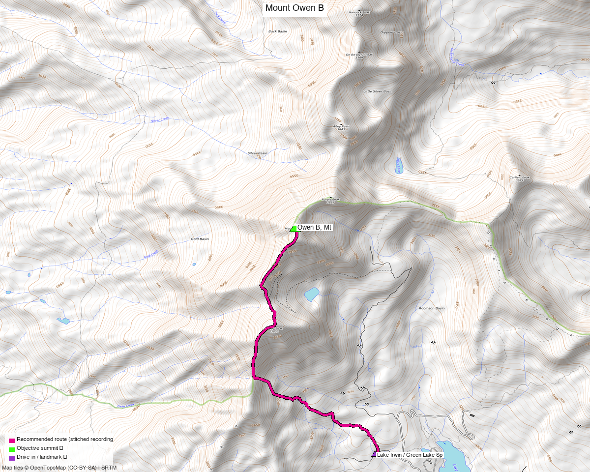
Note: the recommended route was distilled from 8 recorded GPS tracks of real trips (14ers.com · ListsofJohn) — all layered on the interactive CalTopo research map.
The peak
Mount Owen, 13,064' — the only ranked 13er in the Ruby Range, and its high point. peak_db lists it as "Owen B" to distinguish it from the other Colorado Mount Owen.
Gunnison County — Gunnison National Forest, west of Crested Butte above Lake Irwin.
Everything else on this ridge is a twelver: Purple Mountain (12,956'), Purple Peak, Afley Peak, Ruby Peak, Augusta, Richmond, Oh-be-joyful, Hancock, Peeler. They show on the topo around Owen but none is ranked.
Class 3, not the Class 2 on the peak page
listsofjohn and peak_db both grade Owen Class 2. The trip report beta does not agree: LoJ TR 2179 (Furthermore) records "Max difficulty: Minor class 3" for a Ruby Range day including Owen, and a later party treats it as part of the Ruby Range Traverse, a scrambling link-up. The headline here takes the harder figure.
The recommended route — 5.7 mi / 3,405 ft
An out-and-back from the Lake Irwin / Green Lake Spur area, drawn from trk_14ers_4 — the
shortest clean recording in the pool and the only one with a 0.01 mi maximum point gap.
Steep for its length: 3,032 ft of the gain is in the 2.8 mi ascent, and only ~2% of the route is on trail. This is a short day that climbs hard.
The pool ranges from 5.8 to 12.3 miles, and the long end is parties linking Owen into the Ruby Range Traverse over eight or nine twelvers — a point-to-point shuttle, not this route.
Private property on the approach — and OSM does not map it
The beta is explicit about an access complication near the upper parking:
"I started from Irwin Lake but could have driven higher to a small upper parking lot near where the private property boundary issues are (38.88564, −107.11147)… I tried to skirt around his property to reach the base of Ruby." — LoJ TR 20602
The OSM access sweep found nothing there. It returned only the Crested Butte Nordic winter-sports area, which does not touch the route. That is absence of mapping, not absence of a boundary — a landowner issue reported by a climber will not appear in OSM unless somebody has tagged the parcel.
Treat the upper parking and the ground immediately west of it as unresolved, and expect to navigate around private land on foot. The route here starts lower, at the recorded cluster, which avoids the question.
Getting there — Lake Irwin
| Drive from Boulder | ~6h 30m via Google Maps |
| Trailhead | Lake Irwin / Green Lake Spur, 38.88187, −107.11476, 10,395' — from Crested Butte on Kebler Pass Road, then the Lake Irwin turnoff. |
| Road | 2WD to Lake Irwin — the campground road is surface=gravel, smoothness=good. The Green Lake Spur (1D1) above it is surface=dirt, smoothness=very_bad. One party stopped 0.4 mi short of the lake for a snow drift in early June. |
| Land | Gunnison NF — but see the private-property warning above, which OSM does not carry. |
Gear & season
- Best window: July through September. Half the pool is June recordings and one was stopped by a snow drift on the approach road, so early season is a real gamble here.
- Terrain: minor Class 3 per the beta; loose Ruby Range rock. Only ~2% of the route is on trail.
- Helmet: yes, given the Class 3 reporting and the rock quality.
Other considerations
The Ruby Range Traverse is the reason most of these tracks are long. One recorded party links Owen with Purple Mountain, Purple Peak, Afley, Ruby, Augusta, Richmond, Oh-be-joyful and Hancock as a point-to-point shuttle. None of those is ranked, but if you want a big day in this range rather than a summit, that is the shape of it.
Treasure + Treasury are 8 miles north, off the same Crested Butte approach — a 10.1 mi Class 2 loop. At 5.7 miles this one pairs with it naturally for a weekend.
Trip reports & GPX (all three sources)
All three sources swept for this peak and deduped, plus the mapped OSM trail network — all layered on the research map.
- 14ers.com: peak 10132 — 4 GPX-library tracks.
- listsofjohn.com: peak 767 — 4 tracks from 7 trip reports (plus 1 duplicate). LoJ cross-verified the peakbagger id: 5713.
- peakbagger.com: peak 5713 — 2 ascent tracks with GPS, both duplicates of another source.
Sources checked: 14ers.com ✓ · listsofjohn.com ✓ · peakbagger.com ✓