"Lake Fork Peak" via Sayres Gulch
Other climbers: Emily Sharpe — not yet · Shawn D Keil — not yet
At a glance — recommended day
4.9 mi · 2,294 ft gain · Class 2 · 1 peak · ~4.55 h drive
NOAA weather link: "Lake Fork Peak" via Sayres Gulch Weather
Drive from Boulder: 4h 35m via Google Maps
CalTopo research map: https://caltopo.com/m/N00N7R5
Researched: 2026-08-25
Status in Peak Checklist: unclimbed. Rank 367 on the LoJ Colorado 13er list, "Lake Fork Peak" (formerly UN 13322) is the sole remaining unclimbed objective accessible from Sayres Gulch — its natural ridge partner, PT 13,305, is already in the bag. At 4h 35m from Boulder it warrants a pairing-aware approach; see Other considerations below.
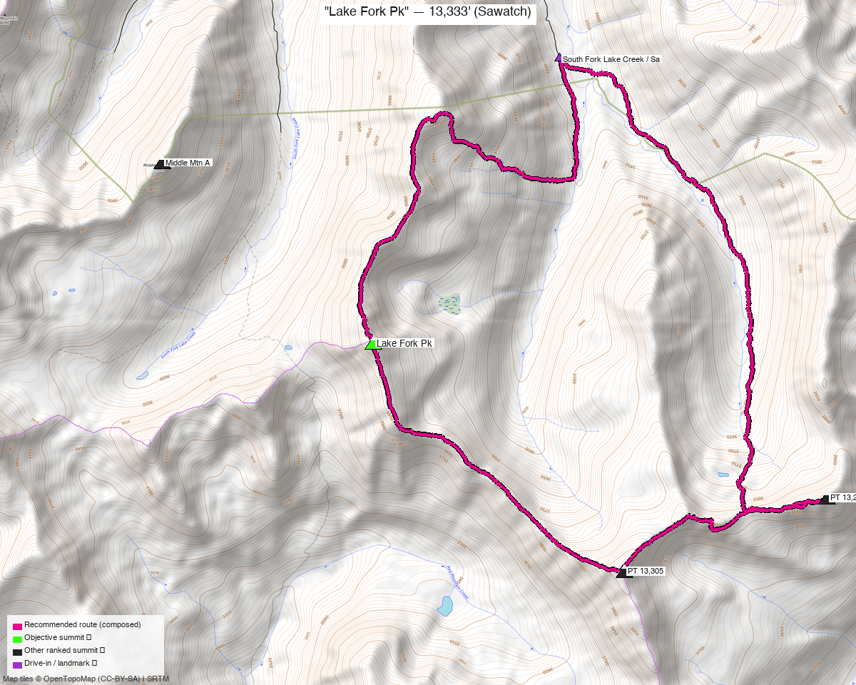
Note: the recommended route was distilled from 5 recorded GPS tracks of real trips (14ers.com · ListsofJohn) — all layered on the interactive CalTopo research map.
Peaks covered
"Lake Fork Peak" sits in the Collegiate Peaks Wilderness, White River National Forest, Sawatch Range, roughly 5 miles south of Independence Pass on the east side of the Lake Creek drainage. The wilderness boundary doubles as the trailhead — Sayres Gulch Road (FR 382) climbs right to the boundary meadow. No permit or day-use fee is required. The summit holds CO rank 367 (LoJ) and was formally unnamed until recent recognition; climb13ers notes that LiDAR added 11 feet to its surveyed height.
| Peak | Elev | Class | CO rank | Status |
|---|---|---|---|---|
| "Lake Fork Peak" | 13,333' | 2 | 367 | unclimbed |
Recommended route — the recommended line ⭐
4.9 mi · ~2,294 ft, Class 2 — A clean out-and-back up Sayres Gulch. The route follows the west bank of the creek on an old road-turned-trail for roughly ¾ mile from the wilderness boundary, then contours up the west side of the valley through open forest and steep grass heading southwest toward upper ponds at ~12,000'. Above the ponds the line picks up a bench, contours SW then S across open tundra, and ascends the northeast slopes of the peak to gain the south ridge at ~13,000'; a short turn north on small rock reaches the summit. climb13ers grades the terrain "tundra stroll / chiprock" — no exposure, easy routefinding, Class 2 end-to-end. The recommended line is composed from a CalTopo recording dated 2024-09-05, the only track in the pool that starts at the 4WD wilderness-boundary TH and covers the objective with no foreign ranked summits.
Route sequence
- Sayres Gulch TH (11,010') — Start at the wilderness boundary meadow; the old road immediately narrows to a trail.
- Creek trail (~¾ mile) — Follow the west bank of Sayres Creek, gaining elevation gradually.
- Valley contour toward upper ponds (~12,000') — Leave the creek corridor and contour southwest up the west side of the valley through open forest and steep grass; some light bushwhacking through the trees before breaking into tundra.
- Bench traverse — Gain a bench above the ponds, then contour SW, S, and SSW across open tundra toward the northeast slopes of the peak.
- Northeast slope ascent → south ridge (~13,000') — Straightforward grass-and-tundra climb to the south ridge.
- Summit — "Lake Fork Peak" (13,333') — Turn north on the ridge; the final stretch is small rock. Wide views down into Taylor Park and the Red Mountain Creek drainage.
- Return — Retrace to the TH.
Getting there — Sayres Gulch TH (11,010')
| Drive from Boulder | 4h 35m via Google Maps |
| Trailhead | Sayres Gulch TH, 39.01901, -106.53412, 11,010' |
| Road | 4WD required for the upper 1.75 miles of FR 382 (Sayres Gulch Road) to the wilderness boundary. High-clearance vehicles without 4WD can reach the FR 391 / FR 382 junction but should park there and walk the remaining 1.75 miles. From HWY 82, turn south onto FR 391 (South Fork Lake Creek Road), cross the Lake Fork bridge, drive ~2.7 miles to the FR 382 fork on the right, then 1.75 miles up Sayres Gulch to the boundary meadow (OSM way 614162703). Note: the parallel road toward Sayres BM / UN 13460 East was Forest Service-gated and closed for restoration as of the climb13ers visit. |
| Land | Collegiate Peaks Wilderness, White River National Forest. No permit or fee required for day use. |
Gear & season
- Best window: July–September. Dated recordings confirm summer (July 2023, July 2024) and shoulder (June 2020, October 2022) ascents — the route stays open into October. South- and east-facing aspects above 12,000' clear of snow early.
- June caveat: north- and east-facing pockets near the summit (~13,000') may hold snow; the upper ponds basin faces SW so it drains fast. Expect no real snow hazard on a standard July–September trip.
- Terrain / gear: All tundra and grass with chiprock on the upper ridge — trail runners or light hiking boots are fine. No scrambling, no technical equipment needed. The valley approach below treeline has brief, light bushwhacking; nothing requiring gaiters.
- Storms: Standard Sawatch afternoon pattern. Aim to summit before noon. The upper basin is fully exposed once you leave the creek corridor.
- Cell: Expect no coverage in the valley or upper basin from the wilderness boundary up; reception typically returns at the FR 391 / FR 382 junction or lower.
Other considerations
Ridge extension — PT 13,295 (already climbed): climb13ers describes "Lake Fork Peak" as pairing naturally with PT 13,305 (LoJ id 502, rank 399) via a nearly 2-mile connecting ridge walk to the south — the canonical same-day linkup from Sayres Gulch. Kyle has already climbed PT 13,305, so this adds no new unclimbed summit and the standalone out-and-back is the right shape for this trip.
Area trip — Grizzly Jenkins group: The three unclimbed Sawatch 13ers nearest to Lake Fork Peak — Jenkins Mountain, PT 13,145, and Grizzly Peak E — are all covered in the Grizzly Pk E + PT 13,145 + Jenkins Mtn report, approached from Pieplant Mill TH on the Red Mountain Creek / Taylor Park side (completely separate drainage, other side of the divide from Sayres Gulch). The two reports share no approach infrastructure and require either two car setups or a driving day between them. At 4h 15–35m from Boulder for both, a multi-day area trip covering both reports is a practical way to justify the drive.
2WD lower start: Higher-clearance vehicles without 4WD can park at the FR 391 / FR 382 junction (~9,850', estimated) and walk FR 382 up Sayres Gulch to the wilderness boundary — adds ~1.75 miles and ~1,160 ft each way (beta's stated gain to the boundary from FR391). The 4WD TH is the default; the lower start is the honest alternative if road conditions or vehicle limits call for it.
Trip reports & GPX (all three sources)
Sources confirmed logged in: 14ers.com ("Basin"), listsofjohn.com ("letsgocu"), peakbagger.com ("Kyle Knutson"). All three swept fresh for this build, plus the mapped OSM trails in the bbox — all layered on the research map.
-
14ers.com: 1 track harvested from the peak page (14ers peak id 10764); this track (trk_14ers_1, 7.3 mi, Aug 2013) was disqualified from the recipe — it starts on the Lake Pass Trail / FR 391 approach corridor and crosses two foreign ranked summits (Middle Mountain A, PT 13,457).
-
listsofjohn.com: 4 tracks harvested from LoJ peak 466, spanning summer (Jul 2023, Jul 2024) and shoulder (Jun 2020, Oct 2022) ascents. All four were disqualified from the recipe: three for crossing foreign ranked summits (up to 4 non-objectives), one (trk_loj_14642) for starting 1.7 miles and 434 ft below the 4WD TH.
-
peakbagger.com: 0 tracks harvested (1 duplicate of a LoJ recording filtered at ingest); peak page pid 15841.
Sources checked: 14ers.com ✓ (logged in, "Basin") · listsofjohn.com ✓ (logged in, "letsgocu") · peakbagger.com ✓ (logged in, "Kyle Knutson")