Other climbers: Emily Sharpe — not yet · Shawn D Keil — ✓ climbed
Fairview Peak — 13,224' (Sawatch / Pitkin)
At a glance — recommended day
5.3 mi · 1,659 ft gain · Class 1 · 1 peak · ~6.31 h drive
NOAA weather link: Fairview Peak (13,224', Sawatch) Weather
Drive from Boulder: ~6h 20m via Google Maps
CalTopo research map: https://caltopo.com/m/LC2DKLF
Researched: 2026-08-17
Status in Peak Checklist: unclimbed. A ranked (CO #464), Class 1 summit in Gunnison County's Gold Basin area, northeast of Pitkin. The approach is a tundra-and-talus walkup with zero exposure — the real challenge is navigating the web of private-property roads above Pitkin to reach the start. See also the combined Gold Basin car-camp trip (Fairview + Henry Mountain in one weekend).
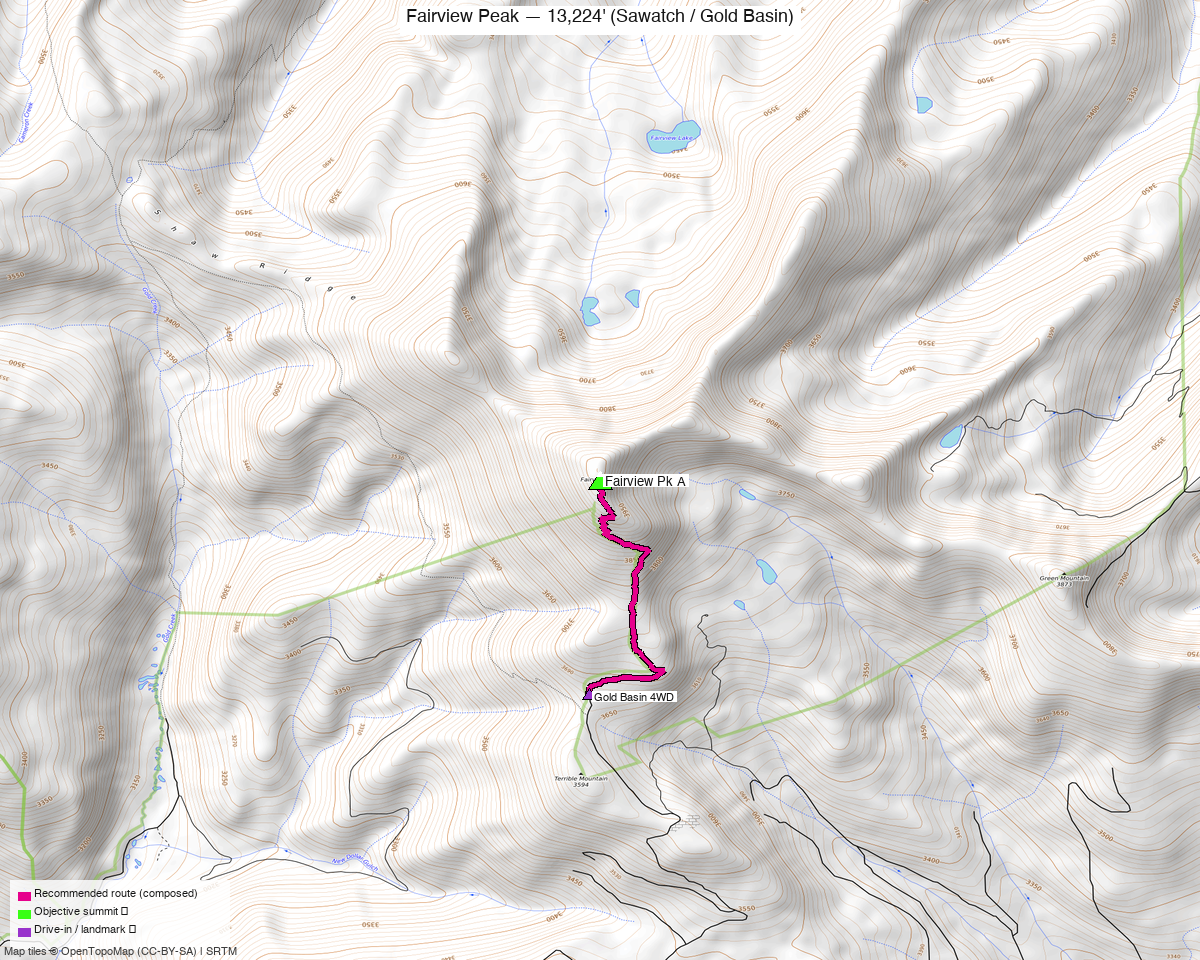
Note: the recommended route was distilled from 7 recorded GPS tracks of real trips (14ers.com · ListsofJohn · peakbagger) — all layered on the interactive CalTopo research map.
Peaks covered
Fairview Peak (13,224', CO rank #464) sits on the Continental Divide above Pitkin, Colorado, in the Gunnison National Forest's Fossil Ridge Recreation Management Area. The summit hosts an 1912 stone fire lookout building — Colorado's highest lookout site — struck by lightning so many times it was abandoned, now in active restoration with a new wood second story. Climb13ers gives it a family rating of 4/5 stars.
| Peak | Elev | Class | CO rank | Status |
|---|---|---|---|---|
| Fairview Pk A | 13,224' | 1 | #464 | unclimbed |
Recommended route — South Ridge ⭐
5.3 mi · 1,659 ft gain (DEM), Class 1 — the South Ridge approach from the Fairview Peak South Ridge TH via trk_14ers_2 (July 2021, summer). Starting from the higher-clearance parking area at the Highline Drive / Terrible Mountain Road junction (~11,440–11,564'), the route follows an old roadbed past the Fairview Mine ruins to the base of the south ridge, then a cairned trail leads to the summit through tundra, embedded rock, and broken talus. Climb13ers describes the steepness as "a pleasant uphill stroll" with no exposure, no scrambling, and easy routefinding.
Route sequence
- From the South Ridge TH (~11,440', Highline Drive / Terrible Mountain Road junction), follow the old Terrible Mountain Road uphill to the ruins of the Fairview Mine (~12,000').
- Beyond the mine, the wide roadbed traces the eastern flank of "Terrible Mountain," gaining elevation gradually along a broad ridgeline above treeline.
- At the base of Fairview Peak's south ridge, a cairned trail heads directly up — tundra first, then embedded rock and broken talus to the summit.
- Top out at Fairview Peak (13,224') and the restored stone fire lookout building. Return as you came.
4WD option
With 4WD and good clearance, you can push Terrible Mountain Road another mile-plus to the Fairview Mine ruins (~12,000') or higher, cutting the round-trip to roughly 4 miles and ~1,100 ft. The Gold Basin trip report uses this upper start for Day 1. The eastern approach via Halls Gulch / FR766 also uses a higher 4WD start (~12,030'), but all eastern approach roads are tagged 4wd_only=yes and smoothness=very_bad in OSM.
Getting there — South Ridge TH, above Pitkin
| Drive from Boulder | ~6h 20m via Google Maps — via US-285 south to US-50 west, then CR76 northeast through Parlin, Ohio, and Pitkin. |
| Trailhead | South Ridge TH, ~11,440', 38.6554, −106.5336 — passenger-car accessible to the "Y" intersection on Highline Drive / Terrible Mountain Road. Per climb13ers, passenger vehicles "may have difficulty reaching this 'Y' intersection," and higher clearance is advisable for the final stretch. 4WD can continue toward or past the mine ruins. |
| Road approach | From the west end of Pitkin, turn onto the county road signed for the cemetery ("Quartz Creek Properties"). Continue past Soul's Ease Road, bear left onto Grasshopper Road, past Skeleton Gulch and Chicago Park roads. Grasshopper becomes Highline Drive. Continue to the Terrible Mountain Road junction — park near this intersection. Navigation is genuinely tricky: property development above Pitkin has added many unmarked spurs, and GPS tracks diverge. The Marianne Curtis county road map (in the climb13ers photo gallery) shows all the new roads. |
| Alternate approach | The Halls Gulch / FR766 eastern approach delivers a longer ~7 mi RT from the east. All eastern approach roads are OSM-tagged 4wd_only=yes + smoothness=very_bad; not recommended without 4WD. |
| Camping | Quartz Creek Campground, ~3–4 mi east of Pitkin on CR765 — free, first-come, the best nearby option. |
| Land | Gunnison National Forest (Fossil Ridge Recreation Management Area NRA) — no permits or fees for day use once past the private-property development roads near Pitkin. |
Gear & season
- Best window: July–September. The upper roadbed and south ridge are entirely above treeline and melt out in early July in a typical year. The June shoulder is possible but the approach roads can hold snow into late spring.
- Terrain: Class 1 throughout — tundra, embedded rock, and broken talus. No scrambling, no exposure. Trail runners work fine. This is a good mountain-running objective.
- Roads: the drive above Pitkin is an honest navigation challenge even with GPS — allow extra time on a first visit and have the Marianne Curtis map loaded offline.
- Storms: the summit is high and the ridge is exposed, but the round-trip is short enough to start later than a typical alpine objective and still be down well before early-afternoon thunderstorms. Check the NOAA forecast.
- Water: no reliable water source on the south ridge above the trailhead — carry the full day's supply from the car.
- Cell: unreliable above Pitkin; carry an InReach or similar.
Other considerations
- Pair with Henry Mountain: Henry (13,272', Class 2) lies ~4.6 mi west in the same Gold Basin / Gold Creek drainage, but accessed via a different trailhead (Gold Basin TH on FR 771, ~10,060'). The approaches don't share infrastructure — different drainages, different roads — so they're separate-trailhead objectives rather than a single-day linkup from one car. The pre-built Gold Basin car-camp trip covers both peaks in one drive from Boulder. With 6+ hours each way, this is the most efficient way to knock out both.
- The fire lookout: the 1912 stone lookout at the summit is a genuine piece of Colorado history, making this an unusual goal for families or groups who want something to see at the top beyond the panorama. The view toward Henry Mountain and the Fossil Ridge Wilderness to the west is expansive.
- Eastern approach alternative: four recorded tracks in the library (trk_loj_18218 Sep 2025, trk_loj_8133 Jun 2020, trk_pb_2 Jun 2020 partial, trk_pb_3 Jun 2020) all use the eastern corridor via 4WD-only roads, producing routes of 6.9–7.2 mi RT from starts at 11,772–12,052'. Not recommended unless you're already based on the east side of the range or have 4WD and want the shorter summit push from the higher start.
Trip reports & GPX (all three sources swept)
Sources confirmed logged in: 14ers.com · listsofjohn.com · peakbagger.com. 7 tracks swept across all three sources (Fairview Peak id 591 / peakbagger pid 15295 / 14ers peakid 10796):
- 2 drawn/approximation lines excluded (trk_14ers_1, trk_pb_1 — no per-point timestamps; check_route_sources FAILs them as a recipe).
- 5 recorded tracks:
- trk_14ers_2 (Jul 2021 — south approach, selected as recommended route, 5.3 mi RT)
- trk_loj_8133 (Jun 2020 — east approach, 7.0 mi RT, starts at 11,772')
- trk_pb_3 (Jun 2020 — east approach, 6.9 mi RT, same start as trk_loj_8133)
- trk_pb_2 (Jun 2020 — east approach, one-way partial, 4WD start)
- trk_loj_18218 (Sep 2025 — east approach, 7.2 mi RT, 4WD-only start at 12,052')
- Recommended route follows trk_14ers_2 verbatim — the only summer recording on the south approach corridor.
14ers.com: 2 tracks (1 drawn excluded; 1 summer 2021 south ridge, selected). peakid 10796.
listsofjohn.com: 2 tracks from trip reports on peak 591; both eastern approach. LoJ also independently confirms YDS Class 1.
peakbagger.com: 3 tracks (1 drawn excluded; 2 recorded, eastern approach, June 2020) + 4 duplicates of other-source tracks. pid 15295 cross-checked against LoJ 591 — verified.
All tracks and OSM trails layered on the research map; recommended route magenta.
Sources checked: 14ers.com ✓ · listsofjohn.com ✓ · peakbagger.com ✓ · climb13ers.com ✓