Chief Mountain A (13,019', Weminuche) — Thirtymile long day
Other climbers: Emily Sharpe — not yet · Shawn D Keil — ✓ climbed
At a glance — recommended day
15.4 mi · 4,142 ft gain · Class 2 · 1 peak · ~7.38 h drive
NOAA weather link: Chief Mountain A (13,019', Weminuche) — Thirtymile long day Weather
Drive from Boulder: ~7h 25m via Google Maps
CalTopo research map: https://caltopo.com/m/7G3CAEK
Researched: 2026-08-06
Status in Peak Checklist: unclimbed. Chief is the loneliest kind of eastern-Weminuche 13er — no ranked neighbor within 9 miles since LiDAR demoted its old partner UN 13,010 to 12,992' — so it has to be gone after deliberately, and it pairs a 7½-hour drive with a 15-mile day. Knocking it out clears one of the most isolated remaining unclimbed San Juans on the list.
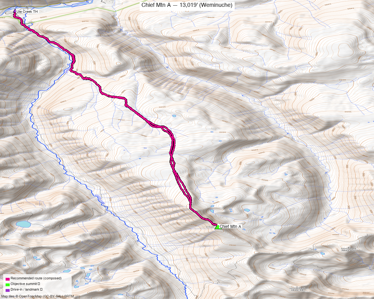
Note: the recommended route was distilled from 6 recorded GPS tracks of real trips (14ers.com · ListsofJohn) — all layered on the interactive CalTopo research map.
Peaks covered
Chief Mountain sits deep in the eastern Weminuche Wilderness (Rio Grande National Forest), south of Rio Grande Reservoir and east of Squaw Pass. LiDAR raised it five feet from 13,014' and simultaneously took away its classic companion — UN 13,010, now 12,992', no longer a 13er — leaving Chief as the only ranked-13er objective in this pocket of the Wemi. The forest on the approach is heavily beetle-killed, the upper terrain is rolling elk-covered tundra, and there are no permits or fees for day use.
| Peak | Elev | Class | CO rank | Status |
|---|---|---|---|---|
| Chief Mtn A | 13,019' | 2 | 625 | unclimbed |
Recommended route — the recommended line ⭐
15.4 mi · ~4,142 ft, Class 2 — the standard Thirtymile day: Squaw Creek Trail to the Fern Creek Trail, then trail's-end tundra south to Chief's north ridge. The line is composed from the best summer recording (June 2022, LoJ) with its recorded side-spurs trimmed — same corridor out and back, so nothing about it is harder than what the party actually walked. Roughly the first 4 miles each way are Class 1 trail; above treeline it's open, landmark-poor tundra where the recordings converge on game trails along the broad ridge. The two shorter lines in the library (15.4–15.5 mi) are May snow recordings and were not used. WildWanderer's 7/30/2023 trip report walks this exact corridor at 16.8 mi / 4,261' and matches the recording turn for turn.
Route sequence
- Thirty Mile TH (9,320') — register and information board just south of the parking area; two trails leave here — take the left one, the Squaw Creek Trail.
- Squaw Creek Trail, 2.3 mi — easy Class 1, over a bridge and paralleling Squaw Creek, with constant small ups and downs you will feel again on the way out.
- Fern Creek Trail junction (~10,000') — just past a drainage-pipe creek crossing, the Fern Creek Trail forks left (SE); the old marker cairn is knocked over, so watch for it. Follow it southeast toward treeline; it fades in a broad gulch — stay left of the willows.
- Treeline (~11,600') — the trail ends. Head south across rolling, landmark-poor tundra (marshy patches and willow bands; the recordings and game trails thread the same line) until Chief's summit mass finally shows.
- North ridge to the summit (13,019') — easy tundra-and-talus ridge walking on elk trails; the first "summit" with a cairn and old marker is false — continue SE along the ridge, where several short Class 2 gullies gain the true summit.
- Return — retrace the whole line (the recorded standard); ~7.7 mi back with a few hundred feet of regain on the Squaw Creek undulations.
Getting there — Thirty Mile TH (Squaw Creek Trail, Thirtymile Campground) (9,320')
| Drive from Boulder | ~7h 25m via Google Maps |
| Trailhead | Thirty Mile TH (Squaw Creek Trail, Thirtymile Campground), 37.72154, -107.25928, 9,320' |
| Road | CO-149 between Creede and Lake City, then ~10 mi of Rio Grande Reservoir Road (FS 520) to Thirtymile Campground — maintained Forest Service gravel, every segment tagged smoothness=good in OSM, and climb13ers rates the TH passenger-car accessible. Park in the signed Backpacker and Angler lot (dirt, no fee). |
| Land | Rio Grande National Forest; the route enters the Weminuche Wilderness shortly beyond the trailhead. No permits or fees for day use; Thirtymile Campground beside the TH is a fee site if car-camping the night before. |
Gear & season
- Window: July–September. The clean recordings are June 2022, June 2013 and September 2014, plus the July 2023 trip report; both May recordings in the library are snow lines. Early season means wet feet — the tundra section crosses marsh and willow bands that hold water into July.
- Class 2, no exposure — tundra, game trails and short blocky gullies at the top; no helmet or rope terrain anywhere on the line.
- Navigation is the crux. Above treeline there are no landmarks for a couple of miles and the trail is gone; carry the GPX. In fog this stretch would be genuinely hard to freelance.
- Start pre-dawn. It's ~7.7 mi to the summit with the last 4 above or near treeline, and the return is long, open and hot; the 2023 party was on trail at 3:30 am and summited before 8. Standard San Juan monsoon rules apply.
- Wildlife everywhere — the 2023 report counted ~200 elk plus moose in the willows; expect the "trails" up high to be theirs.
- No cell service — this is one of the deeper holes in the state; leave an itinerary.
Other considerations
- Make the drive pay twice. At ~7½ hours one-way, this belongs in the same trip as the other unclimbed 13ers on the Rio Grande Reservoir road system: PT 13,274 and PT 13,290 sit ~10 mi west above the Ute Creek drainage (Ute Creek TH is a few miles further up the same road). Chief one day, the Ute Creek pair the next, car-camping at Thirtymile or Ute Creek, turns one brutal drive into three peaks.
- The backpack variant (climb13ers' recommendation) goes in via the Squaw Creek Trail to Squaw Pass and takes Chief from the CDT on its SE ridge — worth it only if adding the demoted UN 12,992 and the 12ers around Squaw Pass matters; as a single objective the day hike is the efficient answer. The 52.9-mi recording in the library is that style of multi-day loop.
- Retrace is the honest shape here. Every recorded day trip goes out and back on the same corridor; a descent variant via Squaw Pass and the Squaw Creek valley trail would make a loop but adds ~4 mi of valley trail with the same undulations. Not recommended as the headline.
Trip reports & GPX (all three sources)
Sources confirmed logged in: 14ers.com ("Basin"), listsofjohn.com ("letsgocu"), peakbagger.com ("Kyle Knutson"). All three swept fresh for this build, plus the mapped OSM trails in the bbox — all layered on the research map.
-
14ers.com: 3 track(s) harvested. Peak page shows 69 member ascents, a 3-file GPX library and 6 trip reports but no route description; WildWanderer's "From Thirtymile Campground" (7/30/2023) is the route beta this report leans on, and two of the three library tracks turned out to be May snow lines.
-
listsofjohn.com: 3 track(s) harvested (+1 duplicate(s) of another source). Four trip reports checked; the June 2022 track (gpx 12793) is the recommended line's source, June 2013 (gpx 138, Furthermore's "Deep Eastern Weminuche" day) is a 29.6-mi longer variant, and gpx 1412 is a 52.9-mi multi-day backpack loop. LoJ also cross-confirmed the peakbagger pid (15195).
-
peakbagger.com: 0 track(s) harvested (+2 duplicate(s) of another source). Both ascent GPX files on the peak page (pid 15195) duplicate tracks already pulled from the other two sources — checked, nothing unique.
Sources checked: 14ers.com ✓ (logged in, "Basin") · listsofjohn.com ✓ (logged in, "letsgocu") · peakbagger.com ✓ (logged in, "Kyle Knutson")