Malemute Peak — Cathedral Lake trail, north side (Elk, Class 2)
Other climbers: Emily Sharpe — not yet · Shawn D Keil — ✓ climbed
At a glance — recommended day
6.7 mi · 3,437 ft gain · Class 2 · 1 peak · ~5.44 h drive
NOAA weather link: Malemute Peak Weather
CalTopo research map: https://caltopo.com/m/6FT74D2
Researched: 2026-07-29
Status in Peak Checklist: unclimbed. A ranked Elk 13er (13,318' LiDAR) in the Castle Creek / Cathedral group above Aspen — parent Castle Peak, 1.18 mi away. Castle, Cathedral, Castleabra, Electric Pass Peak and PT 13,559 are all already climbed, so Malemute is the remaining ranked summit in this cirque.
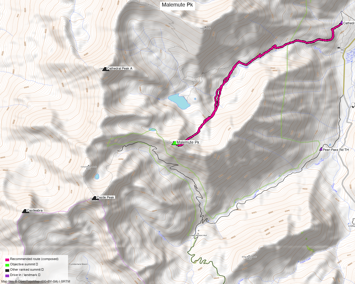
Note: the recommended route was distilled from 14 recorded GPS tracks of real trips (14ers.com · ListsofJohn · peakbagger · Kyle's recordings) — all layered on the interactive CalTopo research map.
Peaks covered
One Class 2 Elk 13er, and a genuinely short day — the shortest of the recent Elk reports.
| Peak | Elev | Class | CO rank | Prom | Status |
|---|---|---|---|---|---|
| Malemute Peak | 13,318' (LiDAR; map 13,348') | 2 | 381 | 333' rise | unclimbed |
Pitkin County, Hayden Peak quad — Maroon Bells–Snowmass Wilderness, White River NF. No permits or fees to climb. With 333' of rise it is a modest ranked summit, which is exactly why it is worth pairing with something else (below).
Recommended route — Cathedral Lake trail ⭐
~6.7 mi · ~3,440 ft round trip, Class 2, a loop from the Cathedral Lake TH (9,911').
The line takes the Cathedral Lake trail up the drainage, then leaves it for Malemute's north side and the 13,318' summit, returning to the trailhead. Class 2 — LoJ rates the peak Class 2, and this route involves no ridge traverse to a harder neighbour, so the summit grade is the route grade.
Why 6.7 mi when recorded tracks from this trailhead run 11.3 mi. The cleanest Cathedral-TH recording (LoJ 904) is 11.27 mi — but it also summits Electric Pass Peak, which you have already climbed. The recommended line is composed to Malemute alone; the extra 4.5 mi and ~2,400 ft in that track buy a peak already in your log. If you want both in a day, follow that recording instead and expect ~11.3 mi / ~5,800 ft.
Route sequence
- From the Cathedral Lake TH (9,911'), take the Cathedral Lake trail up the drainage.
- Leave the trail for Malemute's north side.
- Finish on Class 2 ground to the 13,318' summit.
- Complete the loop back to the trailhead.
Getting there — Cathedral Lake TH (Aspen / Castle Creek)
| Drive from Boulder | ~5h 30m via Google Maps — I-70 west, CO-82 over Independence Pass to Aspen, then Castle Creek Rd |
| Trailhead | Cathedral Lake TH, 39.04287, −106.80812, 9,911' — a mapped highway=trailhead node with a 16-car lot |
| Road | Cathedral Lake Rd is smoothness=very_bad, tracktype=grade3 — rough but far from 4×4-only; good clearance advised. The lot is small, so arrive early. |
| Wilderness | Maroon Bells–Snowmass Wilderness (White River NF) — no permits/fees; standard LNT. |
Do not start high. Two recorded tracks begin at 11,823', ~1,900 ft above this trailhead, up the Pearl Pass 4WD road. That halves the gain, and the report's figures deliberately reflect the honest start from the mapped trailhead.
Gear & season
- Best window: July through September. Castle Creek Rd is paved to the Cathedral turnoff; the last rough mile and the upper basin dry out by early summer.
- Terrain: Class 2 — trail then talus. No rope, axe or crampons in season.
- Vehicle: good clearance for the final rough section; a careful 2WD often manages it dry.
- Storms: classic Elk afternoon monsoon exposure above the lake — early start.
- Cell: patchy in Castle Creek, unreliable in the basin — carry an InReach.
Other considerations
⭐ Pair this with the Pearl + Oyster trip — the trailheads are 11 minutes apart. Measured
trailhead-to-trailhead by road (drive_matrix.py):
| From ↓ / To → | Cathedral Lake TH | Pearl Pass Rd TH | South (Brush Creek) |
|---|---|---|---|
| Cathedral Lake TH | — | ~11 min / 1.8 mi | ~33 min / 3.9 mi |
| Pearl Pass Rd TH | ~11 min / 1.8 mi | — | ~22 min / 2.2 mi |
The Pearl + Oyster report starts from Pearl Pass Rd TH — 1.8 mi from this trailhead — and two of Malemute's own recorded tracks start there too. At ~5½ h each way from home, doing Malemute as its own trip for a 6.7-mile day is poor value: combine it with Pearl and Oyster and get three ranked summits for one drive. Say the word and I will build that as a combined trip rather than two separate reports.
Electric Pass Peak add-on. If you would rather extend the day than combine trips, LoJ track 904 links Malemute with Electric Pass Peak in ~11.3 mi / ~5,800 ft — but that summit is already climbed, so it adds distance, not a tick.
Trip reports & GPX (all three sources)
Sources confirmed logged in: 14ers.com ("Basin"), listsofjohn.com ("letsgocu"), peakbagger.com ("Kyle Knutson"). All three swept, plus the 21 mapped OSM trails in the Castle Creek / Cathedral basin — all layered on the research map.
- 14ers.com: peak page 10113 — 4 GPX-library tracks. No formal 13er route description.
- listsofjohn.com: peak 438 — Class 2 rating; 8 trip reports (secondwind 2026, elijahdgendron 2024, whileyh 2023, josephnephi 2022, Bob Burd 2020, John Kirk 2011, Furthermore 2008, RyanKowalski 2007) and 5 downloadable tracks. 110 members have logged ascents.
- peakbagger.com: peak 60321 — 2 ascent tracks with GPS.
Sources checked: 14ers.com ✓ (logged in, "Basin") · listsofjohn.com ✓ (logged in, "letsgocu") · peakbagger.com ✓ (logged in, "Kyle Knutson")