Cimarron 13ers — Three-Day Car Camp
Other climbers: Emily Sharpe — not yet · Shawn D Keil — not yet
At a glance — 3-day trip
8 peaks · ~8.34 h drive
- Day 1 (Middle Fork six): 15.1 mi · 5,871 ft gain · Class 4 · 6 peaks
- Day 2 (Fortress): 4.4 mi · 2,425 ft gain · Class 4 · 1 peak
- Day 3 (Precipice): 3.3 mi · 2,363 ft gain · Class 4 · 1 peak
NOAA weather link: Cimarron 13ers — Three-Day Car Camp Weather
Drive from Boulder: 8h 25m via Google Maps
CalTopo research map: https://caltopo.com/m/89Q17QQ
Researched: 2026-09-02
Status in Peak Checklist: unclimbed. All eight summits are unclimbed — the most technically demanding cluster in the Cimarron basin, anchored by Heisshorn and El Punto, which rank among the harder Class 4 13ers in Colorado.
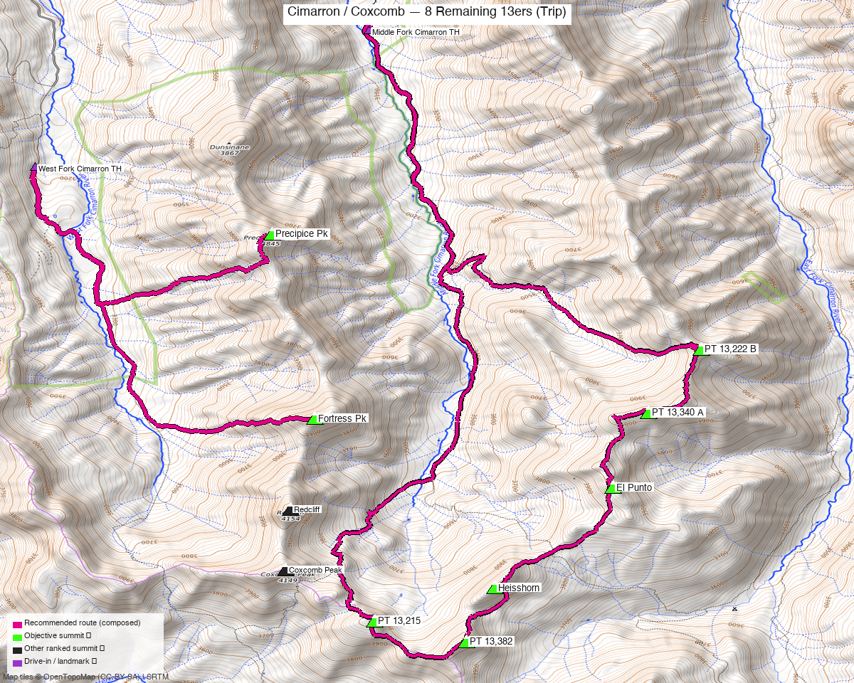
Note: the recommended route was distilled from 25 recorded GPS tracks of real trips (14ers.com · ListsofJohn · peakbagger) — all layered on the interactive CalTopo research map.
Peaks covered
All eight peaks sit in the San Juan Range within the Uncompahgre National Forest, straddling the upper Middle Fork and West Fork drainages of the Cimarron River. The area is genuinely remote — both trailheads are at the end of long dirt roads requiring high clearance or 4WD — but rewards the effort with wide-open basins, spectacular views of adjacent 14ers, and a cluster of summits that rarely see crowds. No wilderness permit is required; fees apply only at the Silver Jack Reservoir campgrounds north of the approaches. The two drainages are separated by the Coxcomb ridge; no single trailhead reaches all eight without crossing a disqualifying foreign summit, which is why this trip splits across three days from two trailheads.
| Peak | Elev | Class | CO rank | Day | Status |
|---|---|---|---|---|---|
| Heisshorn | 13,418' | 3 | 312 | 1 | unclimbed |
| PT 13,382 | 13,382' | 2 | 334 | 1 | unclimbed |
| PT 13,215 | 13,215' | 2 | 476 | 1 | unclimbed |
| El Punto | 13,319' | 3 | 379 | 1 | unclimbed |
| PT 13,340 A | 13,350' | 2 | 357 | 1 | unclimbed |
| PT 13,222 B | 13,220' | 4 | 470 | 1 | unclimbed |
| Fortress Peak | 13,246' | 2 | 445 | 2 | unclimbed |
| Precipice Peak | 13,141' | 2 | 536 | 3 | unclimbed |
Day 1 — Middle Fork six
15.1 mi · ~5,871 ft, Class 4 — counter-clockwise loop from Middle Fork Cimarron TH. Trail #227 runs south through meadows and forest; gain is gentle for the first two miles, then steepens. At 2.2 miles the trail crosses the creek draining Porphyry Basin — the route branches north here to collect PT 13,222 B and PT 13,340 A before swinging south to El Punto and then Heisshorn. Heisshorn NNE Ridge (Class 4, the crux): depart Trail #227 partway up toward the 12,595 ft tundra saddle and trend south onto the north ridge; at 13,000 ft the terrain shifts abruptly from soft dirt and tundra to loose, fragmented rock and boulders for the final ~400 vertical feet — climb13ers calls it "a poor rock and exposure combination" that "deserves care and respect," and rates it among the most difficult 13ers, though most parties complete it without rope. El Punto (Class 4): exposed, loose summit block — "the actual summit feels very exposed, loose rocks abound." PT 13,382 and PT 13,215 close the southern loop and are straightforward Class 2. The recommended line is composed from five clean RT summer recordings (15.3–17.2 mi) that all start within 115 ft of the trailhead and agree on this counter-clockwise sequence; the visit order is pinned due to Class 4 terrain.
Day 1 sequence
- Middle Fork Cimarron TH, 10,044'
- Trail #227 south; Porphyry Basin creek crossing at 2.2 mi — branch north into basin
- PT 13,222 B, 13,220' (Class 4 — peak_db; climb13ers rates Class 3; took harder)
- PT 13,340 A, 13,350' (Class 2+)
- El Punto, 13,319' (Class 4 — exposed, loose summit block)
- Heisshorn, 13,418' (Class 4 — NNE Ridge; loose, fragmented rock above 13,000'; accepted route drop of 334 ft below col between PT 13,382 and Heisshorn, per Kyle's review 2026-09-02)
- PT 13,382, 13,382' (Class 2)
- PT 13,215, 13,215' (Class 2)
- Return to Middle Fork Cimarron TH, 10,044'
Day 2 — Fortress
4.4 mi · ~2,425 ft, Class 3 — Trail #226 from West Fork TH south through open meadows. At ~1.2 miles, leave the trail and head east on the south side of the first drainage below Fortress Peak's west ridge (near N38°05'52" W107°32'55" per climb13ers). Ascend the west ridge directly to the summit — climb13ers describes it as "99% Class 2 or 2+" with a brief Class 3 scramble near the top; just enough route-finding to keep it interesting. Four clean RT recordings confirm this line from West Fork TH; the shortest (4.4 mi, trk_pb_4) was selected.
Day 2 sequence
- West Fork Cimarron TH, 10,752'
- Trail #226 south ~1.2 miles
- Leave trail; head east on south side of drainage, ascend west ridge
- Fortress Peak, 13,246' (Class 3 — brief scramble on west ridge; formerly known as U 3)
- Return to West Fork Cimarron TH, 10,752'
Day 3 — Precipice
3.3 mi · ~2,363 ft, Class 2+ — Trail #226 from West Fork TH south. The Southwest Gully route is the standard line — direct, straightforward, Class 2+ throughout. The selected recording (fp_trk_14ers_8, August 2022, 3.3 mi) is the shortest clean summer RT from this trailhead. A June 2026 shoulder-season recording (3.7 mi) confirms the approach is usable by late June, though expect snow in the upper gully before mid-July.
Day 3 sequence
- West Fork Cimarron TH, 10,752'
- Trail #226 south
- Precipice Peak, 13,141' (Class 2+ — Southwest Gully; also known as U 2)
- Return to West Fork Cimarron TH, 10,752'
Getting there — Middle Fork Cimarron TH (10,044')
| Drive from Boulder | 8h 25m via Google Maps |
| Trailhead | Middle Fork Cimarron TH, 38.1436, -107.5251, 10,044' |
| Road | FR861.1: 4.6-mile gravel spur off FR858 (Silver Jack Reservoir road). High clearance recommended — minor creek crossings have degraded sections in past years; smaller passenger cars have had difficulty. The junction is ~1 mile past Silver Jack Reservoir. Primitive camping and vault toilet at the trailhead. |
| Land | Uncompahgre National Forest. No permit required. Primitive camping allowed throughout; three designated Forest Service campgrounds north of Silver Jack Reservoir. |
Getting there — West Fork Cimarron TH (10,752')
| Drive from Boulder | ~8h 30m via Google Maps |
| Trailhead | West Fork Cimarron TH, 38.1117, -107.5533, 10,752' |
| Road | FR860 from Owl Creek Pass (CR8/CR10 off US 550, 1.8 mi north of Ridgway) or from US 50 via Silver Jack Reservoir. The Courthouse trailhead at ~1.7 mi from CR8 on FR860 is the passenger-car limit. 4WD with good clearance continues ~0.75 mi up a steep, rocky section, past large potholes, then down to a ford of the West Fork — low water crossing that can be difficult in early season. Another 0.7 mi to the "end of the road" trailhead parking. Multiple camping spots along FR860; additional spots near the ford. |
| Land | Uncompahgre National Forest. No permit required. |
Gear & season
- Best window: July–September. Five summer RT recordings (July–September) from Middle Fork TH confirm consistent access. A June 2026 Precipice recording shows shoulder-season use is viable, though the West Fork ford and upper gullies may carry snow before mid-July.
- Heisshorn (Class 4): Helmet strongly recommended on the upper NNE Ridge — the rock is loose and fragmented above 13,000' with genuine exposure. Most recorded parties completed it without rope, but the quality of available protection is described as poor ("if only there was anything solid to anchor to"). Allow extra time and treat this summit with respect.
- El Punto (Class 4): Exposed, loose summit block — careful footwork on the final moves; don't rush the descent.
- PT 13,222 B: Peak_db lists Class 4; climb13ers rates Class 3. The harder estimate is used throughout this report.
- Afternoon thunderstorms: Standard San Juan pattern. Summit by noon on Day 1 is especially important given the number of objectives.
- Water: Trail #227 and Trail #226 both follow perennial streams; filter required.
- Cell: No reliable coverage in remote Cimarron drainages. File a trip plan before departure.
- West Fork ford: Can be difficult in early season (May–June). If the vehicle ford is impassable, look upstream for a log crossing and budget an extra 1.4 mi round-trip on foot.
Other considerations
Far-from-home pairing: At 8h 25m from Boulder this is a committed drive — worth stacking it with nearby objectives. Wetterhorn Peak (14,021', Class 3, loj 61) and Matterhorn Peak (13,590', Class 2, loj 238) sit 1.2 miles from Heisshorn but are accessed via Wetterhorn Basin from a third approach; a fourth day from the Wetterhorn TH would complete the full Cimarron 14er cluster. Uncompahgre Peak (14,318'), visible from PT 13,215's summit, is 2.7 miles from Heisshorn and adds naturally to a longer Cimarron week.
Remaining Cimarron 13ers: The cimarron_six report covers six additional 13ers in the broader Cimarron area not included here.
Coxcomb and Redcliff: These two peaks sit between the Middle Fork and West Fork basins and would otherwise connect this trip into one contiguous approach. Every track that crosses them is disqualified as a foreign summit on this report's objectives — they are not part of this cluster and require their own dedicated day.
Trip reports & GPX (all three sources)
Sources confirmed logged in: 14ers.com ("Basin"), listsofjohn.com ("letsgocu"), peakbagger.com ("Kyle Knutson"). All three swept fresh for this build, plus the mapped OSM trails in the bbox — all layered on the research map.
-
14ers.com: 15 track(s) harvested (+14 duplicate(s) of another source). Peak pages swept for all 8 objectives; this source had the largest pool of clean Middle Fork RT recordings.
-
listsofjohn.com: 6 track(s) harvested (+4 duplicate(s) of another source). All 8 objective pages confirmed; trk_loj_949 (valid, no foreign, covers 3 Middle Fork peaks from West Fork TH) used as corridor evidence for the approach.
-
peakbagger.com: 7 track(s) harvested (+18 duplicate(s) of another source). Fortress (trk_pb_4, Day 2 recipe) and Precipice (fp_trk_14ers_8 via 14ers.com cross-post) sourced from this pool; trk_pb_2 withheld as a drawn line (flagged by density analysis).
Sources checked: 14ers.com ✓ (logged in, "Basin") · listsofjohn.com ✓ (logged in, "letsgocu") · peakbagger.com ✓ (logged in, "Kyle Knutson")