PT 13,557 (13,557', Huerfano Valley Sangres) — Huerfano Creek / North Ridge Route
Other climbers: Emily Sharpe — not yet · Shawn D Keil — ✓ climbed
At a glance — recommended day
6.7 mi · 3,356 ft gain · Class 2 · 1 peak · ~5.86 h drive
NOAA weather link: PT 13,557 (13,557', Huerfano Valley Sangres) — Huerfano Creek / North Ridge Route Weather
Drive from Boulder: 5h 55m via Google Maps
CalTopo research map: https://caltopo.com/m/PFLP84D
Researched: 2026-08-07
Status in Peak Checklist: unclimbed. This is the last unclimbed ranked peak in the entire Blanca/Huerfano cluster — Lindsey, Huerfano Peak, Huerfanito, PT 13,577, California, PT 13,656, Ellingwood, Blanca, Twin Peaks A and Little Bear are all done. It only exists as an objective because the 2022 LiDAR re-evaluation promoted unranked UN 13,555 to ranked PT 13,557, so it appeared on the list after the neighbors were finished; one moderate day closes out the drainage.
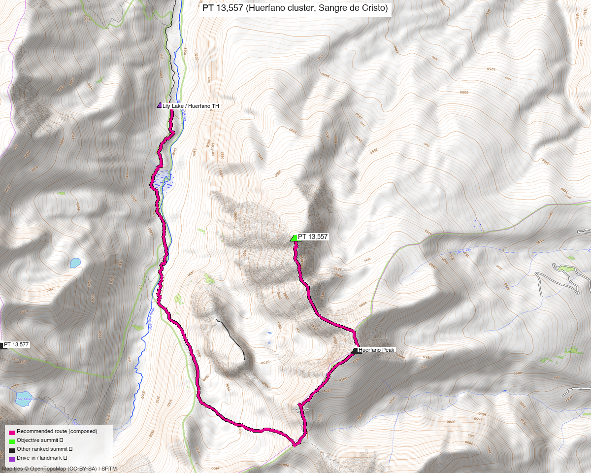
Note: the recommended route was distilled from 8 recorded GPS tracks of real trips (14ers.com · ListsofJohn · peakbagger) — all layered on the interactive CalTopo research map.
Peaks covered
PT 13,557 stands on the tundra ridge east of the upper Huerfano River, a mile south of Huerfano Peak and two miles northeast of Mount Lindsey, in the Sangre de Cristo Wilderness (San Isabel National Forest — the route passes the wilderness boundary sign just above the Huerfano Creek crossing). No fees or permits; standard wilderness rules apply. peakbagger.com calls it "Huerfana Peak" (pid 14638, verified); listsofjohn has it as Peak 13557, and climb13ers as "UN 13557 [Formerly Unranked UN 13555]".
| Peak | Elev | Class | CO rank | Status |
|---|---|---|---|---|
| PT 13,557 | 13,557' | 2 | 216 | unclimbed |
Recommended route — the recommended line ⭐
6.7 mi · ~3,356 ft, Class 2 — an honest out-and-back (no party has recorded a loop here): the Raspberry Trail for the first ~1.3 miles, about a mile of open-forest bushwhack, then two miles of broad tundra ridge to the summit. The line is stitched from the June 2022 party's recording (trk_pb_1), and the July 2025 LoJ recording walks the same corridor independently — this is simply how the peak is climbed. Trail underfoot for roughly two-fifths of the day, zero exposure, routefinding moderate only in the bushwhack band; climb13ers notes strong hikers do the round trip in as little as 4 hours.
Route sequence
- TH (10,200') — the Raspberry Trail marker sits down a short embankment east of the parking pullout and may be hidden in grass. The trail heads east to a kiosk (circle a fallen tree if it still blocks it), crosses a usually-dry wash, and drops to the Huerfano Creek crossing — old cement bridge abutments remain, but today it's slim loose logs or a wade.
- Creek to forested ridge (~11,080') — the trail climbs steeply NE past the Sangre de Cristo Wilderness sign through ~10 short switchbacks. Deadfall obscured the lower switchbacks in July 2022; if you lose the tread, head straight uphill and re-intercept it.
- Leave the trail at 37.63996,-105.46234 where it turns east and levels on the ridge crest (brief first view of the summit here). Bushwhack open forest S/SSE — it steepens around 11,400' (waypoint 37.63189,-105.46040) — and break out onto open tundra at ~11,800'.
- North ridge to the summit (13,557') — follow the broad, snaking tundra ridge south ~2 miles; the last few hundred yards turn to embedded rock and tundra. Summit register found in 2022; the Blanca view is the payoff, with the California Peak rock glacier across the valley.
- Return the same way — 6.7 mi / ~3,356 ft round trip.
Getting there — Lily Lake/Huerfano Creek TH (Raspberry Trail parking) (10,200')
| Drive from Boulder | 5h 55m via Google Maps |
| Trailhead | Lily Lake/Huerfano Creek TH (Raspberry Trail parking), 37.63757, -105.47157, 10,200' |
| Road | 20.8 mi of dirt on CR 550/Huerfano Rd from CO 69 west of Gardner (measured from the creek crossing at the turnoff). Passenger-accessible to the pullout per the beta and all 8 recorded starts; parking fits ~2 vehicles, with an overflow meadow 50 yd south on FR 580B ("park and walk back"). The road's continuation south to the Lily Lake road-end TH is tagged 4wd_only / smoothness=very_bad on OSM — not needed for this route. |
| Land | San Isabel National Forest; the route enters the Sangre de Cristo Wilderness just past the Huerfano Creek crossing. No fees or permits. |
Gear & season
- Best window: July–September. The summer recordings are late June 2022, July 2022 and July 2025; the two November 2021 lines prove the corridor goes in shoulder snow, and the Dec 2020 track shows it as a (much longer) winter outing — but summer is the play.
- Footwear/terrain: trail runners are fine — Class 2 throughout, exposure "None" per the beta. Long pants or gaiters earn their keep in the ~1-mile deadfall bushwhack band between 11,080' and 11,800'.
- Creek crossing: Huerfano Creek is loose logs or a wade right out of the car — in early-season high water, expect wet feet (crossing footwear optional).
- Storms: the final two miles are open tundra ridge above 11,800' with no quick bail into cover — start early and check the NOAA point forecast.
- Cell: expect none in the upper Huerfano valley — it's a deep drainage a long way from towers; don't count on coverage until back out toward Gardner.
Other considerations
- No combo available — and that's verified, not assumed. The 12-mile cluster scan shows every other ranked peak in the Blanca/Huerfano group already climbed; this is a pure mop-up day. Nothing in this drainage can be added without repeating a summit.
- Far-from-home pairing: at 5h 55m each way, this drive wants a second objective — but any pairing has to come from a different corridor (the nearest unclimbed research targets are in other parts of the Sangres, e.g. the Cielo Vista north group at 6h 25m). Worth weighing at trip-planning time rather than forcing into this report.
- Longer variants exist but buy nothing: the July 2022 (14.0 mi) and June 2022 as-recorded (13.9 mi) days wandered far beyond the direct corridor for the same single summit. With a ~4–6 hour round trip on the direct line, the short day is the right day — it leaves the afternoon for the drive.
- Fast day: climb13ers' "strong hikers can complete this in as little time as 4 hours" fits Kyle's fast-hike-up, jog-down pattern; this is a morning.
Trip reports & GPX (all three sources)
Sources confirmed logged in: 14ers.com ("Basin"), listsofjohn.com ("letsgocu"), peakbagger.com ("Kyle Knutson"). All three swept fresh for this build, plus the mapped OSM trails in the bbox — all layered on the research map.
-
14ers.com: 2 track(s) harvested. The gpxlib sweep found 4 GPX URLs already fetched this delta cycle (skipped as fresh); both tracks on disk are winter lines — a 15.3 mi Dec 2020 round trip and a broken 28 mi May 2020 one-way — useful as corridor evidence, rejected for the recommended line.
-
listsofjohn.com: 5 track(s) harvested — all 5 NEW this rebuild from 7 trip reports (this report predates LoJ harvesting in the fleet), spanning Nov 2021 through the July 2025 recording that independently confirms the recommended corridor; LoJ lists the peak as "Peak 13557".
-
peakbagger.com: 1 track(s) harvested (+1 duplicate(s) of another source). Peak page is "Huerfana Peak", pid 14638 (verified against LoJ's cross-link — peak_db ids are checked, not trusted); the June 2022 ascent track it contributed is the recording the composer stitched into the recommended line.
Sources checked: 14ers.com ✓ (logged in, "Basin") · listsofjohn.com ✓ (logged in, "letsgocu") · peakbagger.com ✓ (logged in, "Kyle Knutson")