Boskoff Peak + Fowler Peak + PT 13,575 — Rock of Ages loop (Lizard Head Wilderness, Class 3)
Other climbers: Emily Sharpe — not yet · Shawn D Keil — 1 of 3 (Boskoff Pk)
At a glance — recommended day
15.1 mi · 5,833 ft gain · Class 3 · 3 peaks · ~8.88 h drive
NOAA weather link: Boskoff Group Weather
CalTopo research map: https://caltopo.com/m/M2J7Q98
Researched: 2026-07-30
Status in Peak Checklist: all three unclimbed. They are also the only three unclimbed ranked peaks within 12 miles — Mount Wilson, Wilson Peak, Gladstone, Dolores, Middle Peak and Lizard Head are all already in your log. This is the last unclimbed cluster in the Wilson / Lizard Head area.
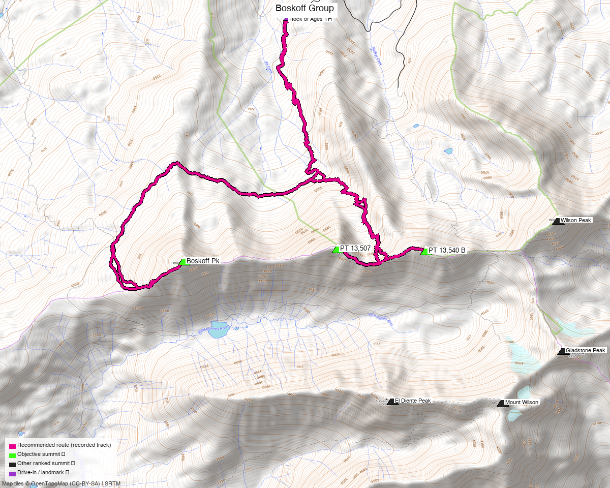
Note: the recommended route was distilled from 14 recorded GPS tracks of real trips (14ers.com · ListsofJohn · peakbagger · Kyle's recordings) — all layered on the interactive CalTopo research map.
Peaks covered
Two of the three carry BGN-official names, and they belong together: Boskoff Peak and Fowler Peak are named for Christine Boskoff and Charlie Fowler, the climbing partners who died in Sichuan in 2006. They are adjacent summits — Boskoff's line parent is Fowler.
| Peak | Elev (LiDAR) | Class | CO rank | Rise | LoJ ascents | Status |
|---|---|---|---|---|---|---|
| Boskoff Peak (alt. "Woods Peak") | 13,134' (map 13,123') | 2 | 540 | 456' | 83 | unclimbed |
| Fowler Peak (alt. "Big Bear Peak") | 13,507' (map 13,498') | 3 | 251 | 346' | 75 | unclimbed |
| PT 13,575 | 13,575' (map 13,540') | 2 | 207 | 526' | 94 | unclimbed |
Dolores and San Miguel counties, Dolores Peak quad — Lizard Head Wilderness, San Juan and Uncompahgre National Forests. No permits or fees.
Note the naming: peak_db still calls these "PT 13,507" and "PT 13,540 B". Lists of John has both the current names and the LiDAR elevations, which is what this report uses.
Recommended route — Rock of Ages loop ⭐
~15.1 mi · ~5,833 ft round trip, Class 3, a loop from the Rock of Ages TH (10,355').
This is one day, not two. Five independent recorded parties link all three summits in a single round trip, so the question is settled by what people actually walked rather than by arithmetic on the map:
| Recording | Distance | Summit order |
|---|---|---|
trk_loj_208 |
11.3 mi | 13,575 → Fowler → Boskoff |
trk_pb_2 |
14.7 mi | 13,575 → Fowler → Boskoff |
trk_14ers_1 ⭐ |
15.1 mi | Fowler → 13,575 → Boskoff |
trk_loj_8567 |
15.1 mi | 13,575 → Fowler → Boskoff |
trk_loj_18588 |
20.5 mi | Boskoff → Fowler → 13,575 (from Kilpacker, a different trailhead) |
The recommended line follows trk_14ers_1 verbatim — a July 2026 recording, the freshest
track in the pool, and a genuine loop that returns within 111 ft of its start.
Why not the shorter 11.3 mi line. trk_loj_208 is the only shoulder-season track in the
pool (June 2013). June at 13,500' in the San Juans takes snow slopes that are not the summer
walking route, and the seasonality rule is to prefer July–September. The 3.8 mi difference was
also checked rather than assumed: check_trip_continuity and audit_route_excursions both come
back clean, so the longer line is not picking up an already-climbed neighbour (Mount Wilson,
Wilson Peak and Gladstone all sit within 2.7 mi) and is not wandering. It is simply a bigger loop
over the same three peaks.
Route sequence
- From the Rock of Ages TH (10,355'), climb south toward the Rock of Ages saddle.
- Take Fowler Peak (13,507') first — the Class 3 summit and the technical crux.
- Continue east along the ridge to PT 13,575 (13,575'), the highest point of the day.
- Return west and traverse to Boskoff Peak (13,134').
- Descend north back to the trailhead, closing the loop.
The ridges are the crux, not the summits
Boskoff and PT 13,575 are Class 2 summits and Fowler is Class 3 — but the connecting terrain is what defines this day, and Wilson-group ridges are notoriously loose. Treat Class 3 as the floor and carry a helmet.
Getting there — Rock of Ages TH (Silver Pick, west of Telluride)
| Drive from Boulder | ~8h 55m via Google Maps — 381 mi (OSRM ~8h 40m + 15 min rough-road pad) |
| Trailhead | Rock of Ages TH, 37.88342, −108.01838, 10,355' — a mapped highway=trailhead node, 0.02 mi from where 10 of the 13 recorded tracks begin |
| Road | Silver Pick Road (way/17144785) and Elk Creek Road (way/441820751) are both 4wd_only=yes, smoothness=very_bad, Forest Service. Real 4×4 — not a clearance-and-hope road. |
| Wilderness | Lizard Head Wilderness (San Juan / Uncompahgre NF) — no permits or fees; standard LNT. |
Confirm the Silver Pick access before you go. Silver Pick Basin has a long private-land history and the Rock of Ages trail exists in its current form because of a reroute around it. The trailhead itself is mapped and public, and every recorded track in this report starts there — but the road status is the thing worth a fresh check in recent trip reports.
Gear & season
- Best window: July through September. 12 of the 13 recorded tracks are summer; the only shoulder track is the June 2013 one this route deliberately does not follow.
- Terrain: Class 3 at the crux, Class 2 elsewhere — loose San Juan rock throughout. Helmet. No rope in season for the standard link-up.
- Vehicle: genuine 4×4 for Silver Pick / Elk Creek Road.
- Storms: classic San Juan monsoon exposure — the day is long and almost entirely above treeline once you leave the basin. Start very early.
- Cell: unreliable; carry an InReach.
Other considerations
This is a standalone trip, and that is unusual. The normal advice for a 9-hour drive is to pair objectives — but there is nothing to pair with. Within 12 miles every other ranked peak is already climbed. These three are the last of the Wilson / Lizard Head area, so the drive buys exactly one outing.
That argues for making the trip longer, not the day. At ~8h 55m each way, consider camping near the trailhead the night before and driving home the following day. The climb itself is a single 15-mile push and does not want splitting — the three summits sit on one connected ridge system, and every recorded party did them together.
The 11.3-mile line is a real option if you catch dry conditions. trk_loj_208 does all three
in 11.3 mi. It is not the recommendation because of its June date, but the terrain it covers is
the same — if late-season conditions are good, it is the efficient version of this day.
Trip reports & GPX (all three sources)
Sources confirmed logged in: 14ers.com ("Basin"), listsofjohn.com ("letsgocu"), peakbagger.com ("Kyle Knutson"). All three swept across all three objective peaks and deduped, plus the 53 mapped OSM ways in the Silver Pick / Woods Lake / Kilpacker area — all layered on the research map.
- 14ers.com: peaks 10549 (Boskoff), 10379 (Fowler), 10365 (PT 13,575) — 5 GPX-library tracks (plus 1 that duplicated another source).
- listsofjohn.com: peaks 690, 321, 282 — 5 tracks harvested from 11 trip reports, and the Class 2 / 3 / 2 ratings this report's grade rests on. 83 · 75 · 94 logged ascents respectively.
- peakbagger.com: peaks 15716, 15186, 14651 — 3 ascent tracks with GPS (plus 1 duplicate).
Sources checked: 14ers.com ✓ (logged in, "Basin") · listsofjohn.com ✓ (logged in, "letsgocu") · peakbagger.com ✓ (logged in, "Kyle Knutson")