PT 13,408 + PT 13,026 — La Garita Wilderness (Cochetopa Creek / Eddiesville)
At a glance — recommended day
15.9 mi · 4,885 ft gain · Class 2 · 2 peaks · ~5.5 h drive
NOAA weather link: PT 13,408 + PT 13,026 Weather
CalTopo research map: https://caltopo.com/m/E0F1BTU
Researched: 2026-06-09
Status in Peak Checklist: both unclimbed.
Split out of the former "Phoenix Park Four." This eastern pair has its own standard trailhead (Cochetopa Creek / Eddiesville, north) — different drainage and a different drive from the western "bridge" pair (13,308 + 13,166) and the Baldy Lejos trio.
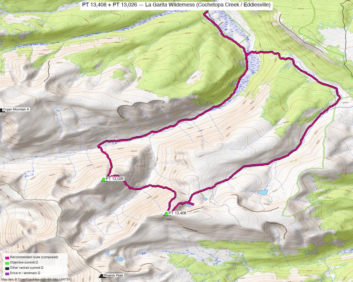
Note: the recommended route was distilled from 11 recorded GPS tracks of real trips (14ers.com · ListsofJohn · peakbagger) — all layered on the interactive CalTopo research map.
Other climbers: Emily Sharpe — not yet · Shawn D Keil — ✓ all
Peaks covered
| PT 13,408 | PT 13,026 | |
|---|---|---|
| Elevation | 13,408' | 13,026' |
| Lat / Lon | 37.9569, −106.8479 | 37.9680, −106.8659 |
| Class | 2 | 2 ("East Flank–NE Ridge", climb13ers) |
| CO Rank | 317 | 622 |
| Also known as | formerly UN 13,402 | formerly UN 13,015 |
| 14ers.com | 10421 | 10602 |
| LoJ | 397 | 806 |
| peakbagger | 84961 | 84919 |
| Peak DB id | 397 | 806 |
The two are ~1.4 mi apart, both Class 2 — climb13ers sequences them as one outing.
Recommended day — Cochetopa Creek / Eddiesville TH (north) ⭐
A long, gentle valley approach up Cochetopa Creek (Continental Divide / Colorado Trail), then into Canon Diablo to gain the peaks — the mileage is mostly the approach; the climbing is easy Class 2.
| Peaks | PT 13,408 + PT 13,026 |
| Recommended loop | A true loop from the Eddiesville TH: up the eastern approach to PT 13,408, NW over to PT 13,026, then down the middle/west corridor — each peak once, no re-climb |
| climb13ers' estimate | ~13.5 mi / ~2,655' — an approximation; its distance is now spot-on (the graph route is also ~13.5 mi), but the 2,655' gain runs well low — net to PT 13,408 alone is ~3,100' from this TH (DEM says ~5,000') |
| Trailhead | Eddiesville / Cochetopa Creek TH (~10,300') — graded but ~30 mi of dirt from the Gunnison/north side |
| Heads-up | significant beetle-kill deadfall / bushwhacking in the approach forest |
The recommended route (bold magenta) — a clean loop through PT 13,408 + PT 13,026 from the Eddiesville TH: up the eastern approach to PT 13,408, over to PT 13,026, and down a separate corridor back to the TH — it tags each peak once and never re-climbs 13,026. Drawn over all the source tracks (green), which sprawl off to San Luis, Stewart, Organ, and Phoenix.
Notes
- PT 13,026 is climb13ers' "East Flank–NE Ridge," sequenced with PT 13,408 across the valley (LoJ TR 26630 did both + extras; 5364 did 13,408 + 13,166 + 13,026 on a San Luis Peak backpack).
Getting there — drive & trailhead
| Drive from Boulder | ~5–6 h via Gunnison → Cochetopa / NN14 (Eddiesville) — a long gravel approach, not the Creede side. (Maps to the TH area) |
| Trailhead | Eddiesville / Cochetopa Creek TH, ~38.025, −106.836, ~10,300' (passenger-car-able with care, ~30 mi dirt). |
| Land | La Garita Wilderness (GMUG NF) — no permits/fees, foot-only beyond the TH; dispersed/backpack camping allowed (handy given the long approach). |
Gear & season
- Best window: July–September; remote, high, snow lingers.
- Terrain: Class 2 tundra/chiprock on the peaks; the work is the long valley approach + beetle-kill deadfall, not technical.
- Storms: exposed once on the divide — early start.
- Cell: dead — carry an InReach.
Other considerations
- Alternate access — Phoenix Park (Creede, south): both are also reachable from the Phoenix Park 4WD road, but that's a longer, rougher day (the old "Phoenix Park traverse"). The Cochetopa side is the shorter standard.
- This pair is also natural to fold into a San Luis Peak / Stewart Creek backpack (TR 5364), since you're already deep in the La Garita.
Trip reports & GPX (all sources)
Sources confirmed logged in: 14ers.com ("letsgocu"), listsofjohn.com, peakbagger.com. 14ers-library tracks (Cochetopa/Eddiesville and Phoenix Park approaches) are layered on the CalTopo map.
- listsofjohn.com: TR 26630 (13,408 + 13,026 + Ribbed Pk ridge), TR 5364 (with San Luis Peak / Baldy Alto backpack).
- peakbagger.com: both verified — La Garita Wilderness (GMUG NF).
- climb13ers.com: UN 13,026 "East Flank–NE Ridge" — 13.5 mi / 2,655' (an estimate; the recorded-GPX clean loop is ~13.5 mi / ~5,000' DEM — climb13ers' distance matches but its gain runs low; see the recommended-day note).
Sources checked: 14ers.com ✓ (logged in, "letsgocu") · listsofjohn.com ✓ · peakbagger.com ✓ · climb13ers.com ✓