Chipeta Mountain (13,495', Far Southern Sawatch) — Marshall Pass Loop
Other climbers: Emily Sharpe — ✓ climbed · Shawn D Keil — ✓ climbed
At a glance — recommended day
8.2 mi · 3,272 ft gain · Class 2 · 1 peak · ~4.98 h drive
NOAA weather link: Chipeta Mountain (13,495', Far Southern Sawatch) Weather
Drive from Boulder: ~5h 00m via Google Maps
CalTopo research map: https://caltopo.com/m/L5VH4BU (regional Sawatch map; individual research map TBD)
Researched: 2026-08-12
Status in Peak Checklist: unclimbed. Chipeta Mountain is a tidy, relatively short day — one of the most accessible ranked 13ers in the Far Southern Sawatch. At 8.2 miles round trip from Marshall Pass, it's a moderate loop that gains the Continental Divide on the Monarch Crest Trail and follows it north to the summit. No technical terrain; just clean tundra walking at altitude, ~5 hours from Boulder.
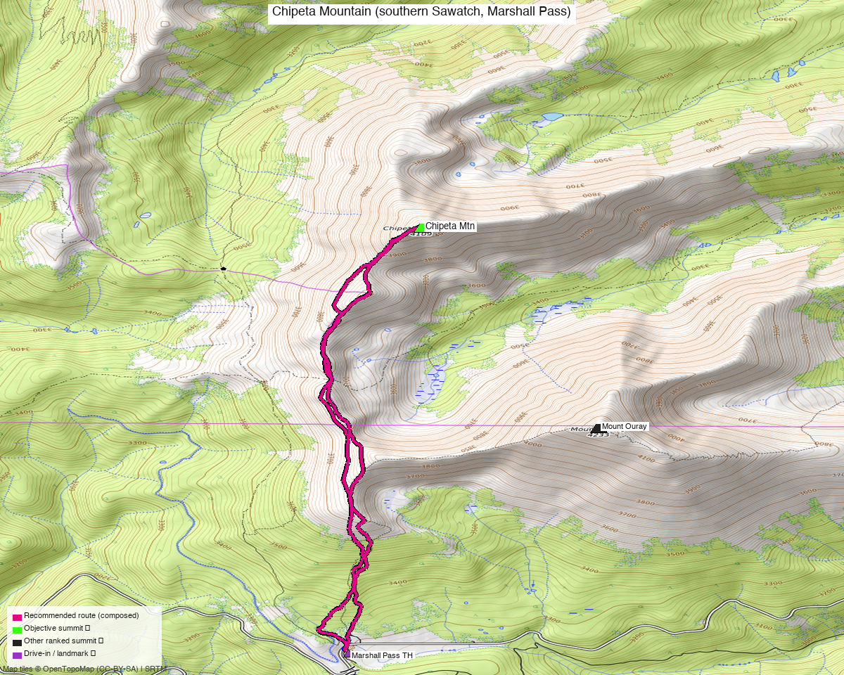
Note: the recommended route was distilled from 1 recorded GPS tracks of real trips (14ers.com · ListsofJohn · peakbagger) — all layered on the interactive CalTopo research map.
Peaks covered
Chipeta Mountain (13,495', CO rank #259 among 13ers) sits ~2.6 miles north of Marshall Pass along the Continental Divide in the Far Southern Sawatch — in Chaffee County, on land administered by the Pike and San Isabel National Forest. Its 1,200' of clean prominence (LiDAR) earns it a firm position on the CO 13er list. The name honors Chipeta, the Ute peace activist and wife of Chief Ouray; the peak was long labeled "Peak 13,472" on USGS maps, with the lower 12,850' South Peak holding the Chipeta name — the US Board of Geographic Names issued a formal correction establishing the 13,495' summit as the rightful Chipeta Mountain.
Mount Ouray (13,979', CO rank #57) is the nearest neighbor, 1.93 miles north on the same divide; Kyle has already climbed it. Adding Ouray to this day is a well-documented extension — an ~12.5 mi loop with ~5,600' gain (the Chipeta+Ouray combined day is what peakbagger user Isaac Porter logged on 2025-06-08), but Ouray is already in the tick-list.
| Peak | Elev | Class | CO rank | LoJ | Status |
|---|---|---|---|---|---|
| Chipeta Mtn | 13,495' | 2 | 259 | 337 | unclimbed |
Recommended route — Marshall Pass CDT loop ⭐
~8.2 mi · ~3,272 ft gain, Class 2 — a loop from Marshall Pass on the Continental Divide Trail (CDT) / Monarch Crest Trail north to Chipeta Mountain and back, built from the OSM trail network. The route heads north from the parking area along the signed CDT, following the divide ridge through rolling tundra as the trail gains steadily toward the summit plateau. The return makes a slight loop variant, keeping the day interesting and avoiding a pure out-and-back. Class 2 throughout — tundra, talus, and well-established trail on the ridge crest; no scrambling, no exposure.
The peakbagger track (trk_pb_1.gpx, Isaac Porter, 2025-06-08) covers both Chipeta and Ouray in a 12.5 mi loop with ~5,666' GPS-logged gain — a useful confirmation that the whole corridor goes on recorded tracks. The single-peak Chipeta day from the same TH is a notably shorter and more moderate undertaking.
Route sequence
- Marshall Pass TH (10,853') — park at the summit-of-pass parking area (OSM way/264517896, access=yes, fee=no), just west of the saddle on Marshall Pass Road (FS 200). The CDT/Monarch Crest Trail heads north from the pass; pick it up at the trailhead sign.
- CDT north up the divide — the trail follows the Continental Divide ridge north, climbing through sub-alpine meadows and scattered krummholz into open tundra. Monarch Crest Trail segments (OSM ways 215256968 + 649616568) carry most of the approach. Grade is steady but not severe; the divide stays mostly above 11,500' the entire way.
- Cross the 12,295' key col (LiDAR) between Marshall Pass and Chipeta — the low point between the Marshall Pass drainage and the Chipeta massif. From here the summit is visible to the north; the trail continues up the broad east-facing slope.
- Summit — Chipeta Mtn (13,495') — broad tundra summit with excellent views north to Mt. Ouray and south toward the Marshall Pass divide. The summit is identified by the USGS benchmark and a register; the actual high point is the LiDAR-verified 13,495' top (the lower 12,850' South Peak visible to the SSE is NOT Chipeta — see history note in the "Peaks covered" section).
- Return loop — descend south via a slightly varied line back to Marshall Pass, keeping the return interesting and avoiding a strict out-and-back; the CDT/Monarch Crest Trail segments offer a loop possibility through the upper basin.
Getting there — Marshall Pass TH (10,853')
| Drive from Boulder | ~5h 00m via Google Maps — US-285 south to Poncha Springs, then west on US-285/CO-285 through Moffat, then turn west on Marshall Pass Road (FS 200) at a signed junction south of Poncha Springs. |
| Trailhead | Marshall Pass TH, 38.39500, −106.24756, 10,853' — the summit of Marshall Pass. |
| Road | Marshall Pass Road (FS 200): maintained gravel, OSM tracktype=grade2, smoothness=bad — bumpy but passable with a standard 2WD vehicle (high clearance helpful for comfort, not required). Several 4WD-only spurs (East Road/200.F Road/Hutchinson Cabin Road) branch off but are NOT the approach; stay on the main FS 200. Drive time from the junction: ~30–45 min. |
| Land | Pike and San Isabel National Forest — no permits or fees for day use. |
Gear & season
- Best window: July–September. Known ascents span late May through late October: Whiley Hall, 2020-05-31 (late spring, LoJ TR); josephnephi, 2023-08-27 (summer); Alyson Kirk, 2014-10-24 (fall, LoJ TR). A June 2019 party (bergsteigen, 14ers) did a ski ascent — winter/spring snow conditions. Summer season opens when the divide clears in late June; expect lingering snowfields through early July in high snow years.
- Terrain/gear: tundra, talus, CDT trail — trail runners are fine. No helmet or rope terrain. Microspikes useful for shoulder-season lingering snow on the upper divide. Water is not available above the TH (the divide is above all drainages); carry the full day's supply.
- Storms: the CDT ridgeline is fully exposed above tree line for almost the entire route — zero shelter. A pre-dawn start is strongly recommended; thunderstorms build fast over the Sawatch in July–August. If cells build, descent south into the Marshall Pass basin is fast.
- Cell: minimal to none on the divide; reliable near Poncha Springs on approach. InReach recommended for this remote corridor.
Other considerations
- Chipeta + Ouray combo (if re-climbing Ouray): If revisiting Mt. Ouray is of interest, the combined loop is a well-documented and efficient day — ~12.5 mi, ~5,600' gain from the same TH. The peakbagger track (Isaac Porter, 2025-06-08) demonstrates this linkup. Both peaks are on the same divide, the approach is shared, and the saddle between them is the 12,295' key col. This is only relevant for re-climbing Ouray since Kyle has already checked that one off.
- No other unclimbed ranked peaks share this approach: within a 12-mile radius, only Chipeta is unclimbed by Kyle. The drive is ~5 hours, so this is an efficient single-peak day with nothing else nearby to batch. There's no combined-trip opportunity for new peaks.
- South Peak confusion: the lower 12,850' Chipeta Mountain South Peak (peakbagger pid 32559) is visible to the SSE and was the historical "Chipeta" on USGS maps. It's not the objective and not ranked on any list Kyle is pursuing — don't confuse the two. The objective is the 13,495' summit to the north.
- Mileage note: the 14ers.com page has no posted route description for this peak (routes section says "Sorry, no route descriptions have been added"). The route shape comes from the OSM trail network and the peakbagger loop track — which confirms the recommended line follows the CDT approach. The LoJ page is the authoritative source for the Class 2 rating and 1,200' of prominence.
Trip reports & GPX (all three sources)
Sources confirmed logged in: 14ers.com ("Basin"), listsofjohn.com ("letsgocu"), peakbagger.com ("Kyle Knutson"). All three swept fresh for this build (2026-08-12), plus 45 mapped OSM trail segments in the Marshall Pass bbox — all layered on the regional CalTopo research map.
Note on track quality: no timestamped GPS recordings exist for this route. All swept tracks are drawn lines (peakbagger exports GPS tracks with timestamps stripped; CalTopo tracks from map L5VH4BU similarly lack per-point timestamps). The route was built from the OSM trail graph rather than a specific recording. The PB track (trk_pb_1.gpx, Isaac Porter, 2025-06-08) is the most useful shape reference and confirms the CDT approach to Chipeta + Ouray is a documented loop.
-
14ers.com: 4 track(s) in library (all duplicates of peakbagger/CalTopo tracks; 1 fetched without a usable track). No route description posted for this peak; the library tracks were contributor imports. Peak page: 10745.
-
listsofjohn.com: 3 track(s) harvested (all duplicates of other sources). Trip reports: josephnephi (2023-08-27), whileyh (2020-05-31), James Hitch (2017-06-30), Alyson Kirk (2014-10-24), avalletta (2012-11-23). 155 members have reported ascents on LoJ. Peak page: 337.
-
peakbagger.com: 4 track(s) (1 unique — trk_pb_1.gpx, Porter 2025-06-08, 12.5 mi Chipeta+Ouray loop; 3 duplicates). 39 ascents logged. Verified pid: 16206. Peak page: 16206.
Sources checked: 14ers.com ✓ · listsofjohn.com ✓ · peakbagger.com ✓ · climb13ers.com (no page cached)