Brown Mountain
Other climbers: Emily Sharpe — not yet · Shawn D Keil — ✓ climbed
At a glance — recommended day
9.2 mi · 3,677 ft gain · Class 2 · 1 peak · ~7.95 h drive
NOAA weather link: Brown Mountain Weather
Drive from Boulder: 8h 00m via Google Maps
CalTopo research map: https://caltopo.com/m/QS1KMGU
Researched: 2026-08-31
Status in Peak Checklist: unclimbed. Rank #362 in Colorado with 647 ft of prominence — the top unclimbed peak in the Red Mountain/Ironton corridor southwest of Ouray, and a natural anchor for an Ouray-area trip that can stack several more Ironton-area 13ers in the same approach zone.
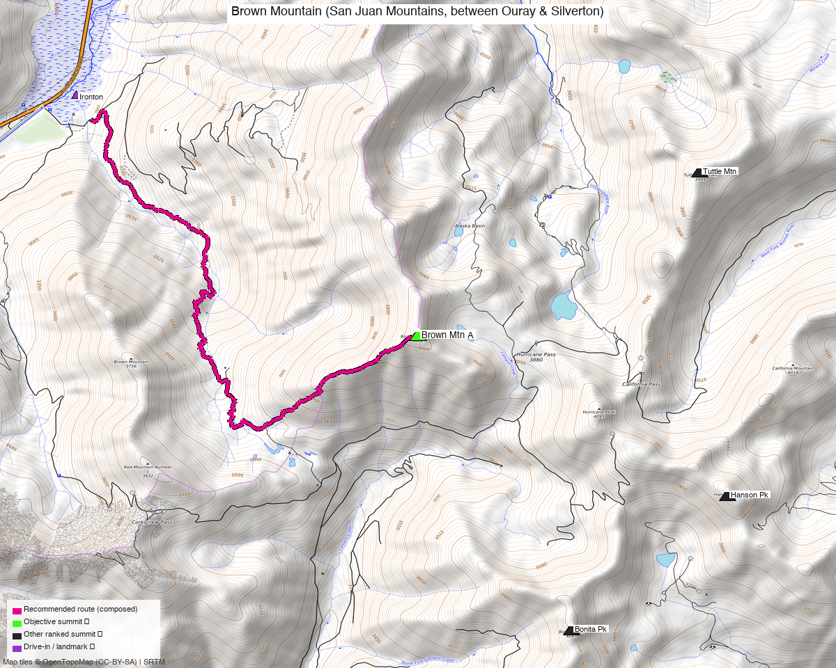
Note: the recommended route was distilled from 5 recorded GPS tracks of real trips (14ers.com · ListsofJohn · peakbagger) — all layered on the interactive CalTopo research map.
Peaks covered
Brown Mountain is a San Juan 13er in the Red Mountain/Ironton corridor, accessed off US550 (the Million Dollar Highway) southwest of Ouray — Uncompahgre National Forest, no wilderness designation, no permit, no fee. The peak carries no official name: on the 1955 USGS Ironton quad it appears as "DUCO VABM 13,339" and LoJ lists "Duco Benchmark" (NGS datasheet HL0647) as the alternate name. LiDAR measurements added 8 feet to the surveyed elevation, raising it from 13,339' to 13,347' and bumping the LoJ rank from #364 to #361.
| Peak | Elev | Class | CO rank | Status |
|---|---|---|---|---|
| Brown Mountain A | 13,347' | 2 | 362 | unclimbed |
Recommended route — the recommended line ⭐
9.2 mi · ~3,677 ft, Class 2 — Composed from the September 2024 CalTopo recording (starts 296 ft from Ironton TH, 11.3 mi raw round trip; dense GPS, max gap 0.02 mi). The line climbs Brown Mountain Road / Corkscrew Gulch (FR886) from Ironton, gains the upper basin, and finishes on the southwest ridge — entirely Class 2 tundra and rubble, zero exposure, straightforward routefinding. climb13ers: "a short and easy Class 2 hike over a mix of tundra and rubble."
Route sequence
- Ironton TH (9,700') — park at the Ironton Park area off US550; pick up Brown Mountain Road heading east.
- Brown Mountain Road / Corkscrew Gulch (FR886) — follow the road east and up through the gulch; very steep and narrow in places. 4WD-capable shorter-bed vehicles can drive to ~11,797' on the road, shortening the outing substantially.
- Upper basin / tundra slopes — leave the road and bear south-southwest up the steep south-facing tundra slope, gaining ~600 ft to the southwest ridge.
- Southwest ridge → summit, Brown Mountain A (13,347') — follow the grassy and rocky ridge to the top; register present, no windbreak.
- Return the same way.
Getting there — Ironton TH (9,700')
| Drive from Boulder | 8h 00m via Google Maps |
| Trailhead | Ironton TH, 37.93837, -107.67064, 9,700' |
| Road | US550 south from Ouray ~9 miles to Ironton; park near Ironton Park Nordic Trails area (4 OSM parking nodes/ways within 0.25 mi). Brown Mountain Road (FR886 / Corkscrew Gulch) begins ~0.25 mi east — gravel, then 4WD-only. climb13ers: "very steep sections, very narrow for much of its length and has some very tight switchbacks — longer bed vehicles not advised." Shorter-bed capable 4WDs can continue to ~11,797'. |
| Land | Uncompahgre National Forest; no wilderness designation, no permit, no fee. Primitive camping at Ironton Park along the road into Corkscrew Gulch and at sites southwest of Ironton along US550. |
Gear & season
- Season: July through October. All clean summer/fall records land in August, September, and October; the climb13ers first ascent was September. The 13,347' summit sits exposed on an open ridge — no windbreak at the top; the Cooneys battled "strong September winds" on their day.
- Afternoon thunderstorms: standard San Juan pattern July–August; start early, plan to be off the ridge by noon.
- Terrain: entirely Class 2 — tundra and rubble, no scrambling, no exposure. Trekking poles optional.
- Gear: standard Colorado 13er day kit — layers, rain shell, wind layer (that summit has no shelter), sun protection. No helmet, no harness.
- Cell: expect spotty to none above Ironton Park. Ouray has service; plan accordingly.
Other considerations
Ironton corridor trip pairing. At 8 hours from Boulder, Brown Mountain is too far to stand alone. The Red Mountain/Ironton area is dense with unclimbed 13ers on the same approach infrastructure: Tower Mountain (rank 224, Class 2), Telluride Peak (rank 245, Class 2), Storm Peak A (rank 261, Class 3), Chicago Peak (rank 326, Class 2), Dome Mountain A (rank 338, Class 2), T 7 (rank 351, Class 2), and T 8 (rank 385, Class 2) are all within 6 miles and all unclimbed. Several already have or will have their own reports built from this corridor; Brown Mountain pairs most naturally with whichever Ironton-area group shares access from US550 / Red Mountain Pass.
Gray Copper Pass southern approach. climb13ers rates the Silverton approach as "easiest vehicle access": drive northwest through Silverton, follow CO110 north 7.5 miles to Gladstone, veer left on CR10 north ~1.9 miles, hard left ~1,000 ft to parking near the pass (~11,635'). From the pass: ~3 mi RT / ~1,705 ft gain — substantially shorter than the Ironton start. The Cooneys drove it in a stock Cherokee Sport in 2002 but caution that the road may have deteriorated with heavy ORV use since. No recorded track cluster exists from that direction in the current pool. Kyle noted it as a potential future primary approach: "maybe we swap over to that in the future when there's more time to develop — bonus points if it can compose a route from there."
Higher 4WD start. Capable shorter-bed 4WD vehicles can drive Brown Mountain Road / FR886 to ~11,797' (the cluster-5 area), which would materially reduce both distance and gain from the Ironton base. The current report starts at the Ironton TH per Kyle's deviation; if road access to the upper trailhead becomes the normal condition, a revision to that start would cut the outing roughly in half.
Trip reports & GPX (all three sources)
Sources confirmed logged in: 14ers.com ("Basin"), listsofjohn.com ("letsgocu"), peakbagger.com ("Kyle Knutson"). All three swept fresh for this build, plus the mapped OSM trails in the bbox — all layered on the research map.
-
14ers.com: 3 track(s) harvested (+2 duplicate(s) of another source). Peak page for Brown Mountain (peakid=10441) confirms Class 2; page includes a handful of trip reports covering both the Ironton and Silverton approaches.
-
listsofjohn.com: 2 track(s) harvested (+1 duplicate(s) of another source). Peak #451 carries 125 member ascents with trip reports through October 2024; YDS Class 2; key col 12,700'; alternate name "Duco Benchmark" (NGS HL0647).
-
peakbagger.com: 3 track(s) harvested (+4 duplicate(s) of another source). PID 60362; 24 logged ascents; prominence 646.6 ft; LoJ rank #361 (pre-LiDAR #364).
Sources checked: 14ers.com ✓ (logged in, "Basin") · listsofjohn.com ✓ (logged in, "letsgocu") · peakbagger.com ✓ (logged in, "Kyle Knutson")