Grizzly Pk E + PT 13,145 + Jenkins Mtn — Sawatch
At a glance — recommended day
7.4 mi · 4,441 ft gain · Class 2+ · 3 peaks · ~4.2 h drive
NOAA weather link: Grizzly Pk E + PT 13,145 + Jenkins Mtn Weather
Drive from Boulder: ~4h 15m via Google Maps
CalTopo research map: https://caltopo.com/m/RT6G46G
Researched: 2026-06-09
Status in Peak Checklist: all unclimbed.
Which "Grizzly Peak"? This is Grizzly Peak E (13,309') — the Pieplant/Taylor Park summit that links with Jenkins and PT 13,145 — not Grizzly Peak A (13,997', the famous near-14er near Independence Pass, a separate outing ~6 mi north).
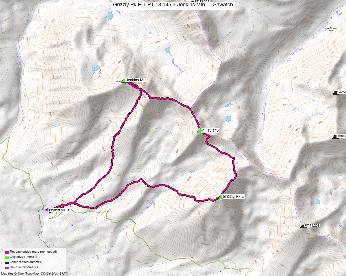
Note: the recommended route was distilled from 17 recorded GPS tracks of real trips (14ers.com · ListsofJohn · peakbagger) — all layered on the interactive CalTopo research map.
Other climbers: Emily Sharpe — not yet · Shawn D Keil — not yet
Peaks covered
The three form a N→S ridge chain: Jenkins (north) → PT 13,145 (0.7 mi) → Grizzly Pk E (1.0 mi), climbed as one loop from Pieplant. (Nearby "Lake Fork Pk" — once bundled here as an optional 4th — is now its own report; it sits 5.6 mi north with a separate approach.)
| Jenkins Mtn | PT 13,145 | Grizzly Pk E | |
|---|---|---|---|
| Elevation | 13,440' | 13,145' | 13,309' |
| Lat / Lon | 38.96511, −106.54299 | 38.95539, −106.52653 | 38.94244, −106.52203 |
| Class | 2 | 2 | 2+ (boulder/talus) |
| CO Rank | 297 | 531 | 393 |
| Also known as | — | UN 13145 / "UN 13140 B" | (pre-LiDAR 13,281) |
| 14ers.com | 10754 | 10807 | 10778 |
| LoJ | 370 | 666 | 515 |
| peakbagger | 15652 | 84735 | 55291 |
| Peak DB id | 370 | 666 | 515 |
Recommended route — Jenkins + PT 13,145 + Grizzly E loop from Pieplant ⭐
The standard outing: a counter-/clockwise loop from the Pieplant Mill site taking in all three. Per climb13ers, the loop is 9.15 mi / 4,810' (GPX tracks below range ~7.5–9 mi and ~5,300–6,800', depending on line and how directly the ridge is followed). Class 2+ overall — the "+" is Grizzly E's boulder-talus.
| Peaks | Jenkins Mtn + PT 13,145 + Grizzly Pk E |
| Distance / gain | ~9 mi / ~4,800–5,300' loop |
| Class | 2+ (Grizzly E boulder/talus; an ice axe is worth carrying early season) |
| Terrain | tundra low, then a difficult ridge section, a talus-filled gully, and relentless boulder-talus up high |
| Trailhead | Pieplant Mill site (~10,200') |
Route sequence
- From the Pieplant Mill site, walk the old mining road north up to the Pieplant Mine (~10,800').
- At about 11,000', leave the roadbed and head NE up an intermittent drainage, then angle SE onto a minor ridge/slope that joins the south ridge of Jenkins.
- Follow the south ridge (tundra giving way to rock) to where it meets the east ridge; turn NW over chiprock/talus to the Jenkins summit (13,440') — ~2.5–3 hr from the TH.
- Continue south along the connecting ridge over PT 13,145 and on to Grizzly Pk E (13,309') — this is where the day earns its Class 2+: a tricky ridge section, a talus gully, and sustained boulder-hopping.
- Descend Grizzly's slopes back toward Pieplant to close the loop (or reverse the ridge).
Direction: most parties go Jenkins-first (north end) then traverse south to Grizzly. Either way it's a loop back to Pieplant.
Getting there — Pieplant Mill site
| Drive from Boulder | ~4h 15m via Google Maps (origin: 1162 Peakview Circle). climb13ers: "over four hours" for Front Range or West Slope climbers. |
| Trailhead | Pieplant Mill site, ~38.9398, −106.5600, ~10,200', NE of Taylor Park Reservoir. |
| Access | From Gunnison: US-50 → SH-135 to Almont → FR 742 (Taylor Canyon) to Taylor Park Reservoir, then continue north on FR 742 (east side) ~6.5 mi to the Pieplant turnoff/mill. From the Front Range, the shorter line is via Buena Vista + Cottonwood Pass (seasonal) into Taylor Park. |
| Vehicle | Higher-clearance 2WD is enough — 4WD not required to the mill site (per climb13ers). |
| Land | All public National Forest — GMUG NF (Jenkins, Grizzly E), Pike & San Isabel NF (PT 13,145). No wilderness, no permits, no fees (confirmed on peakbagger "Land" fields). |
Gear & season
- Best window: July through September. High Sawatch; the Pieplant/Taylor Park roads and Cottonwood Pass open late spring, and north-facing gullies hold snow into early summer.
- Crux is terrain, not technical: sustained boulder-talus and a talus-filled gully on the Jenkins→Grizzly ridge — slow, ankle-aware going. Carry an ice axe early season for the gully (climb13ers recommends one).
- Storms: a long, exposed ridge day — start early and be off the crest by early afternoon.
- Cell coverage: no submitted 14ers.com reception reports for these summits or the Pieplant TH; the Pieplant/Taylor Park drainages are likely dead (deep valleys NE of the reservoir) — summits may catch intermittent signal but treat it as unreliable. Carry an InReach / satellite messenger — remote trailhead, long loop.
Other considerations
Adding "Lake Fork Pk"? It's now its own report — Lake Fork Pk. It sits 5.6 mi north of Jenkins with a separate approach (no trail links it to the trio), so it's a distinct outing rather than a 4th peak on this loop. A fit party can tack it on as a long ~13–15 mi day, but it's more efficient on its own — see that report for the standard line.
Trip reports & GPX (all sources)
Sources confirmed logged in: 14ers.com ("letsgocu"), listsofjohn.com (logged in), peakbagger.com ("Kyle Knutson"). 11 GPX tracks swept (7 from the 14ers library, 4 from LoJ) — all layered on the CalTopo map, colored by source.
14ers.com GPX library (logged in, "letsgocu")
The trio is well-covered by recent uploads:
| Track | Peaks | Year |
|---|---|---|
| "2nd annual broncothon – Jenkins, 13145, grizzly" | trio (+extras) | 2025 |
| "Jenkins-13145-Grizzly" | trio | 2025 |
| "Jenkins Moun #1" | trio | 2021 |
| trip 14059 | Savage + Grizzly + 13145 | 2013 |
| "Meet me in the Middle – Sawatch trio" / rachel upload | Lake Fork (+ Middle Mtn) | 2013 / 2024 |
listsofjohn.com (logged in)
| GPX | Peaks |
|---|---|
| TR 1803 | all three (Jenkins + 13,145 + Grizzly E) |
| TR 5603 | Jenkins + PT 13,145 |
| TR 5670 | Grizzly Pk E |
| TR 26979 | Jenkins + PT 13,145 + Lake Fork (the optional-4th proof) |
| TR 16363 | Lake Fork Pk |
peakbagger.com (logged in, "Kyle Knutson")
Peak pages verified for all four (Jenkins 15652, Grizzly E 55291, PT 13,145 = "Peak 13144" 84735, Lake Fork = "Peak 13331" 15841); used to confirm land ownership (all public NF). No downloadable ascent GPX on these pages.
climb13ers.com
Route beta for all peaks: Jenkins South Ridge · Grizzly Pk E NE Ridge · "Lake Fork Peak". The Grizzly E page documents the Jenkins–UN13,140–Grizzly loop (9.15 mi / 4,810').
Sources checked: 14ers.com ✓ (logged in, "letsgocu") · listsofjohn.com ✓ (logged in) · peakbagger.com ✓ (logged in, "Kyle Knutson") · climb13ers.com ✓