Hesperus + Lavender + Babcock — the three ranked La Plata 13ers (Class 3+)
Other climbers: Emily Sharpe — not yet · Shawn D Keil — 1 of 3 (Hesperus Mtn)
At a glance — recommended day
11.3 mi · 4,673 ft gain · Class 3+ · 3 peaks · ~9.19 h drive
NOAA weather link: La Plata Mountains Weather
CalTopo research map: https://caltopo.com/m/8MHBCPN
Researched: 2026-08-01
Status in Peak Checklist: all three unclimbed.
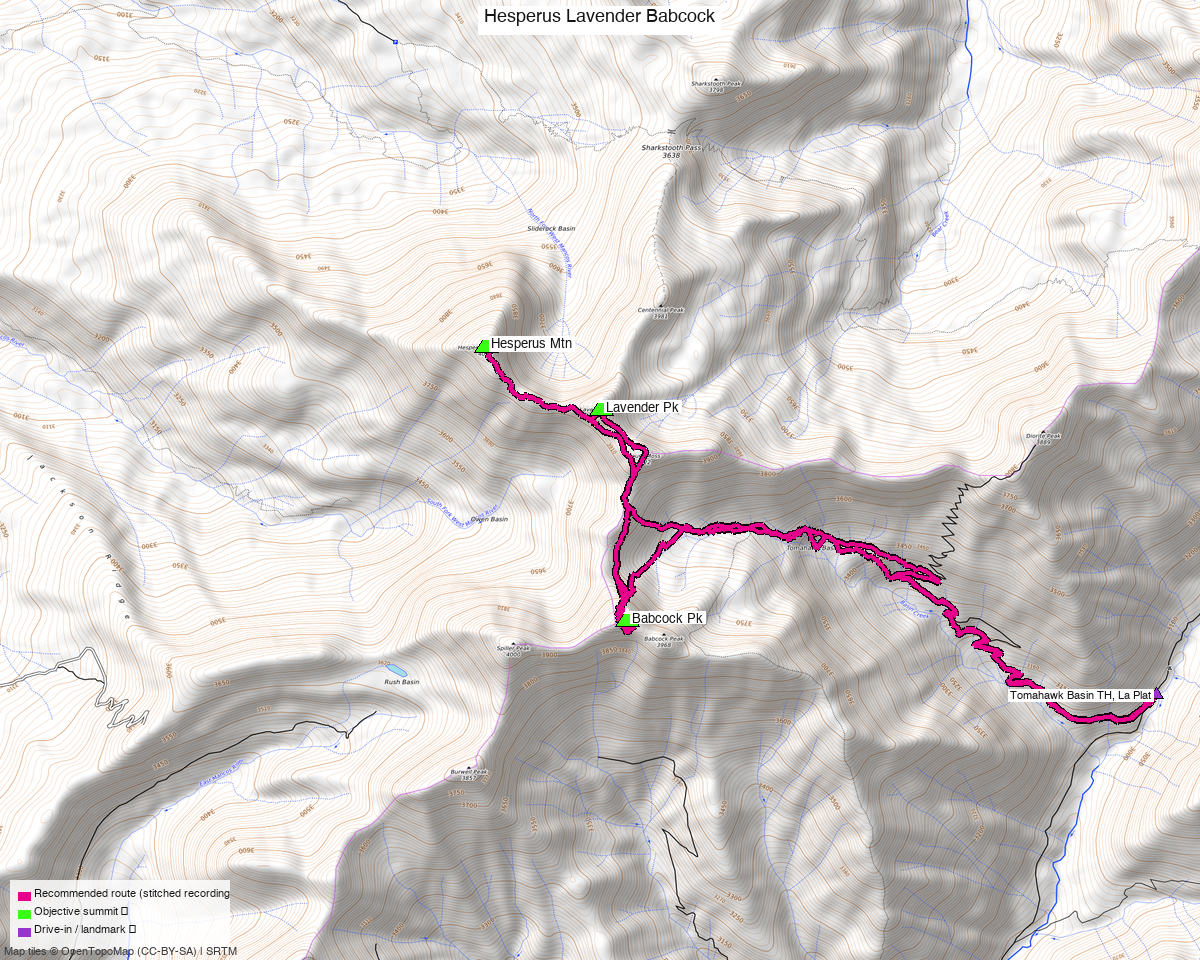
Note: the recommended route was distilled from 20 recorded GPS tracks of real trips (14ers.com · ListsofJohn · peakbagger) — all layered on the interactive CalTopo research map.
This is one day, not a multi-day car camp
Worth saying up front, because the map suggests otherwise. These three sit around separate basins — Tomahawk, Boren Creek, and the north side — and most recorded parties do indeed take them one basin at a time over several outings from a La Plata Canyon camp.
But one party did all three in a single 11.4 mi round trip from the Tomahawk Basin
trailhead (trk_loj_14558, July 2023 — they picked up unranked Mount Moss on the way too), and
that line is what this route follows. 11.3 mi / 4,673 ft is an ordinary big day, not an
expedition.
If you would rather split it, La Plata Canyon is set up for exactly that: plenty of Forest Service camping, most of it fee sites, plus — per the trip report that named the trailhead — "a nice large and free camp site" less than 0.2 mi up the road, with no cell service.
Peaks covered
| Peak | Elev | LoJ class | peak_db says |
|---|---|---|---|
| Hesperus Mtn | 13,238' | 2+ | 2 |
| Lavender Pk | 13,237' | 3+ | 3 |
| Babcock Pk | 13,161' | 3+ | 3 |
La Plata County — San Juan National Forest. peak_db understates all three; the grades above come from the LoJ peak pages and are corroborated by trip reports.
Centennial Peak, Mount Moss and Spiller Peak sit right alongside these and show on the map, but they are unranked, which is why they are not objectives. Moss in particular is nearly free — the recording this route follows tagged it in passing.
Babcock has a false summit, and the wrong couloir forces 5th class
This is the thing to get right. Babcock Peak is a cluster of towers, and the approach couloirs are easy to confuse. From LoJ TR 7480 (John Kirk):
"I read a report on 14ers.com prior to arriving that really confused the matter of which couloir to take up and I ended up 5th classing some rock to get out near the top of a couloir that was too far west… We ended up on the western summit of Babcock and realised that we ascended the incorrect couloir."
Getting to the true summit took downclimbing, traversing east to the west face of the true massif, and going up chimneys. A second party calls the peak "loose and steep… solid, sustained C3+ scrambling with exposure."
Two of the recorded GPS tracks in this pool stop 525 and 603 ft short of the true summit — almost certainly on the wrong tower. The route here is anchored on the true summit (37.42956, −108.07928, confirmed against both listsofjohn and peakbagger), so follow the line rather than the topography, and expect to be on rock rather than talus at the top.
The recommended route — 11.3 mi / 4,673 ft
A loop from Tomahawk Basin, in the order the recording walked it: Babcock → Hesperus → Lavender. Babcock first, while you are fresh, which is the right way round given it is the technical one.
| Leg | Distance | Gain |
|---|---|---|
| TH → Babcock Pk | 4.25 mi | 3,343 ft |
| Babcock → Hesperus Mtn | 2.69 mi | 1,085 ft |
| Hesperus → Lavender Pk | 0.62 mi | 291 ft |
| Lavender → TH | 3.74 mi | 217 ft |
Every leg comes from the same recording, trk_loj_14558 — unusually, the composer found no
better stitch, because that party's line is already the efficient tour. Roughly half the
approach and half the descent are on trail.
Getting there — Tomahawk Basin, La Plata Canyon
| Drive from Boulder | ~9h 15m via Google Maps — the longest drive of any report on this site. |
| Trailhead | Tomahawk Basin, 37.42516, −108.04314, 9,892', up La Plata Canyon from Mancos/Hesperus. |
| Road & parking | Rough 2WD. Space for about three vehicles off the side of the road. |
| Camping | Plenty of Forest Service sites in La Plata Canyon, most with fees; a free site sits <0.2 mi up the road. No cell service. |
| Land | San Juan NF. The access sweep found no restricted or private land anywhere in the box. |
Gear & season
- Best window: July through September. The pool is unusually snow-heavy — five recordings are November, April or May — so shoulder-season conditions clearly linger here.
- Terrain: sustained Class 3+ with exposure on Babcock; Class 3+ on Lavender; Class 2+ on Hesperus. Loose rock throughout.
- Helmet: yes, and a partner. Babcock is the sort of peak where a wrong turn escalates.
Other considerations
Hesperus is a sacred Navajo mountain — Dibé Nitsaa, one of the four sacred peaks marking the boundaries of Dinétah. Worth knowing whose ground you are on.
If you want more while you are down there, Centennial, Moss and Spiller are all unranked but immediately adjacent, and the recorded line already brushes Moss. Sharkstooth Peak sits just north.
Trip reports & GPX (all three sources)
All three sources swept across all three objective peaks and deduped, plus the mapped OSM trail network — all layered on the research map.
- 14ers.com: peaks 10489, 10498, 10516 — 5 GPX-library tracks.
- listsofjohn.com: peaks 559, 576, 656 — 4 tracks from 14 trip reports (plus 2 duplicates). LoJ cross-verified the peakbagger ids: 5849 / 17448 / 17449.
- peakbagger.com: peaks 5849, 17448, 17449 — 11 ascent tracks with GPS (plus 4 duplicates).
Sources checked: 14ers.com ✓ · listsofjohn.com ✓ · peakbagger.com ✓