Pearl + Oyster (13,379' + 13,316', Castle Creek, Elks)
Other climbers: Emily Sharpe — not yet · Shawn D Keil — ✓ all
At a glance — recommended day
9.5 mi · 4,011 ft gain · Class 2 · 2 peaks · ~5.64 h drive
NOAA weather link: Pearl + Oyster (13,379' + 13,316', Castle Creek, Elks) Weather
Drive from Boulder: ~5h 40m via Google Maps
CalTopo research map: https://caltopo.com/m/P2T2NDV
Researched: 2026-08-06
Status in Peak Checklist: unclimbed. Pearl (CO rank 339) and Oyster (384) are the highest-ranked pair still standing in the Castle Creek pocket — two Class 2 ticks in one 9.5-mile day, in a drainage where Castle, Castleabra and Cathedral are already done. The 5½-hour drive is the tax; the day itself is moderate.
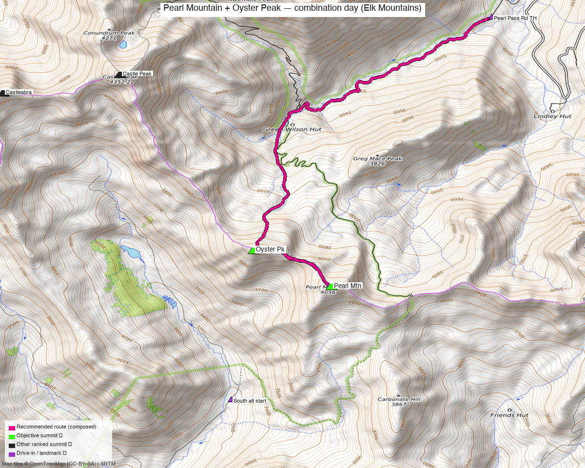
Note: the recommended route was distilled from 7 recorded GPS tracks of real trips (14ers.com · ListsofJohn · peakbagger) — all layered on the interactive CalTopo research map.
Peaks covered
Pearl Mountain and "Oyster Peak" sit on the ridge east of Pearl Pass at the head of Castle Creek, south of Ashcroft in the Elks (White River National Forest). They face Castle Peak across the valley and are climbed together essentially always — a 0.76-mile Class 2 saddle ridge separates the summits. LiDAR added 17 feet to Pearl. No permits or fees; the Tagert and Wilson-Green backcountry huts along the approach are rental-only, not public shelters.
| Peak | Elev | Class | CO rank | Status |
|---|---|---|---|---|
| Pearl Mtn | 13,379' | 2 | 339 | unclimbed |
| Oyster Pk | 13,316' | 2 | 384 | unclimbed |
Recommended route — the recommended line ⭐
9.5 mi · ~4,011 ft, Class 2 — the standard Ashcroft-side day, composed from the July 2024 recording (the only summer line from this trailhead) with a 0.37-mi detour trimmed: road walking up FR 102 and the Pearl Pass Road to the huts and the alpine (roughly 60% of each approach leg is on the road corridor), then Pearl's tundra-and-talus north ridge, the short saddle ridge across to Oyster, and back the same way. No exposure anywhere; the composer's leg costs show ascent and descent share 97% of their ground — this is an out-and-back with a two-summit crest, not a loop.
Route sequence
- Castle Creek TH (10,120') — park where FR 102 crosses Castle Creek at the end of the good road; everything beyond is rough 4WD.
- Road to the huts (~1.8 mi) — walk WSW up FR 102, then left onto the Pearl Pass Road (FR 129) past two switchbacks to the Tagert and Wilson-Green huts (~11,300'). The road gets rocky immediately after the turn.
- Pearl Pass Road into the alpine — continue up the 4WD road as it climbs out of the trees into the upper basin; the recording leaves the road around 11,800' where Pearl's north ridge line becomes obvious.
- Pearl Mtn (13,379') — tundra then moderately stable talus up the ridge; a satisfying grind, never harder than Class 2.
- Saddle ridge to Oyster Pk (13,316') — drop ~400' to the connecting saddle and cruise the 0.76-mi crest; easy Class 2 the whole way.
- Return — back over or around Pearl's shoulder and retrace the basin and road to the TH (~4 mi, essentially all descent).
Getting there — Castle Creek TH (FR 102 crossing, Pearl Pass Rd) (10,120')
| Drive from Boulder | ~5h 40m via Google Maps |
| Trailhead | Castle Creek TH (FR 102 crossing, Pearl Pass Rd), 39.01748, -106.81329, 10,120' |
| Road | Castle Creek Road from Aspen — paved past Ashcroft to the FR 102 crossing. Park there: every road beyond (Pearl Pass Rd FR 129, Cooper Creek, Montezuma) is tagged smoothness=very_bad in OSM, and climb13ers says short-wheelbase 4WD only. A capable 4WD can drive FR 129 to ~11,500' and cut ~4 mi / 1,000' off the day. |
| Land | White River National Forest (Aspen–Sopris RD). No permits or fees. The Tagert / Wilson-Green huts are reservation-only rentals — not public shelter. |
Gear & season
- Window: July–September. The summer evidence is July 2024 (the route source), July 2020 and September 2014. Four of the seven recordings are winter/spring ski lines (Mar 2026, May 2020 ×3) — this basin is a classic ski-touring zone, which says something about how long snow lingers; expect snowfields on the north ridge into early July (climb13ers recommends an ice axe early season).
- Class 2 throughout — tundra, scree, moderately stable talus; no helmet/rope terrain, easy routefinding.
- Storms: the crest from Pearl to Oyster is committed open ridge; standard Elks monsoon timing — summits by noon.
- No cell in upper Castle Creek beyond Ashcroft.
Other considerations
- Make the 5½-hour drive buy two days. Malemute Peak (13,318', unclimbed) climbs from Cathedral Lake TH a few miles back down the same Castle Creek Road — Pearl + Oyster one day, Malemute the next, out of one Aspen-side base. The Star Peak Group 2-day (Star + Taylor, both unclimbed) works the same crest from the Crested Butte side and is the other natural companion trip.
- The 4WD shortcut is real: the July 2020 recording starts at 11,483' on the Pearl Pass Road and makes it an 8.4-mi outing with ~1,000' less gain. Recommended only with a genuinely capable short-wheelbase rig — the road's OSM tags and beta agree it's rough.
- The Crested Butte approach (September 2014 recording, 12.3 mi from 10,763' on the south Pearl Pass Road) is legitimate but the wrong direction from Boulder unless already basing in CB.
Trip reports & GPX (all three sources)
Sources confirmed logged in: 14ers.com ("Basin"), listsofjohn.com ("letsgocu"), peakbagger.com ("Kyle Knutson"). All three swept fresh for this build, plus the mapped OSM trails in the bbox — all layered on the research map.
-
14ers.com: 3 track(s) harvested. All three from the GPX libraries are winter/spring ski lines (March 2026 from the seasonal closure, two from May 2020) — season evidence, not the summer route.
-
listsofjohn.com: 2 track(s) harvested (+1 duplicate(s) of another source), from 10 trip reports scanned across both peaks. The July 2024 recording (gpx 16132) is the recommended line's source; gpx 948 is the September 2014 Crested Butte–side day. LoJ cross-confirmed both peakbagger pids (Pearl 39830, Oyster 29599).
-
peakbagger.com: 2 track(s) harvested (+3 duplicate(s) of another source), no Cloudflare wall this sweep. The July 2020 high-start (4WD) round trip and a May 2020 ski line; the other three ascent files duplicated tracks already pulled.
Sources checked: 14ers.com ✓ (logged in, "Basin") · listsofjohn.com ✓ (logged in, "letsgocu") · peakbagger.com ✓ (logged in, "Kyle Knutson")