Other climbers: Kyle Knutson — ✓ all · Shawn D Keil — 1 of 4 (PT 13,486)
Clohesey Four — Magdalene + Pear + 13,513 + 13,486 (Sawatch)
At a glance — recommended day
12.2 mi · 5,714 ft gain · Class 2+ · 4 peaks · ~2.75 h drive
Written for Emily — four ranked Sawatch 13ers above Clohesey Lake, linked in one day.
Status for Emily: all four unclimbed (on her 14ers checklist). A tidy cluster above Clohesey Lake in the Collegiate Peaks, SW of Missouri/Belford.
Four Class 2 ranked 13ers on the ridge above Clohesey Lake — Magdalene Mtn, "Pear Pk", PT 13,517 A ("UN 13,513"), and PT 13,486. They link into one ~12 mi loop; the only real catch is the brutal 4x4 road to Clohesey Lake (there's a walk-in alternative below).
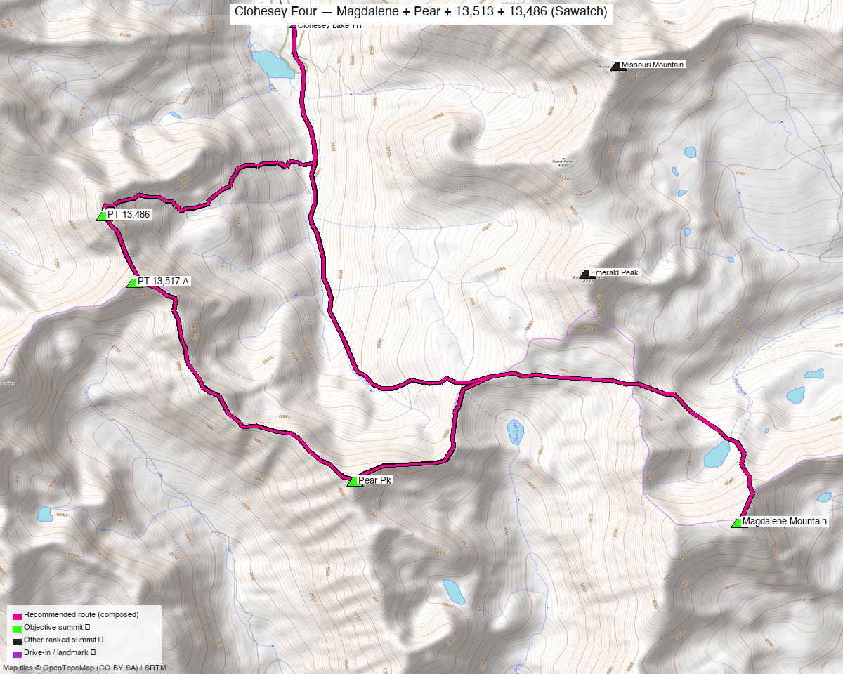
Note: the recommended route was distilled from 22 recorded GPS tracks of real trips (14ers.com · ListsofJohn · peakbagger) — all layered on the interactive CalTopo research map.
NOAA weather link: Clohesey Four Weather
CalTopo research map: https://caltopo.com/m/P38PGQ6
Peaks covered
| Magdalene Mtn | "Pear Pk" | PT 13,517 A ("13,513") | PT 13,486 | |
|---|---|---|---|---|
| Elevation | 13,780' | 13,459' | 13,513' (LiDAR) | 13,486' |
| Lat / Lon | 38.9070, −106.3676 | 38.9106, −106.4021 | 38.9283, −106.4218 | 38.9342, −106.4248 |
| Class (summit) | 2 | 2 | 2 | 2 |
| CO Rank | 118 | 285 | 249 | 270 (newly LiDAR-ranked) |
| 14ers.com | 10709 | 10747 | 10741 | 10746 |
| LoJ | 145 | 347 | 303 | 339 |
| peakbagger | 5687 | 19618 | 14667 | 58396 |
| Peak DB id | 145 | 347 | 303 | 339 |
All four are ranked Class 2 Sawatch 13ers. They sit in a ~3 mi arc above Clohesey Lake: 13,486 + 13,517 A at the NW end (~0.5 mi apart), Pear in the middle, Magdalene the high point at the SE end.
The link-up — one loop over all four ⭐
Yes, all four link in one outing — a Class 2+ loop from the Clohesey Lake TH:
- Loop order: Clohesey Lake TH → PT 13,486 → PT 13,517 A (the close NW pair) → "Pear Pk" → Magdalene Mtn → back to the lake (reverse works too).
- Difficulty: all four summits are Class 2. The connectors are Class 2 to a max of Class 2+ — including the 13,517 A ↔ 13,486 link, which a recorded TR (2023) specifically documents as "class 2+ max" (the author wrote it up precisely because there wasn't much beta on linking 13,513 with the newly LiDAR-ranked neighbor). Route also on the Cooneys' climb13ers site.
- Tundra and talus, no technical sections — the day is the mileage + gain, not difficulty.
If the full day is too long on foot, the cluster also splits cleanly: NW pair (13,486 + 13,517 A) and Pear + Magdalene are each a shorter loop from the lake.
Getting there — the Clohesey Lake road (and the walk-in alternative)
| Drive from Denver | ~2h 45m via Google Maps — via US-285 / Leadville to US-24, then Clear Creek Rd (CR 390) west toward Vicksburg; the Clohesey Lake road branches south off it. |
| Trailhead | Clohesey Lake TH (~38.951, −106.408, ~11,000') — 4x4 only up the road. Park-low option at the Clear Creek Rd / Clohesey road junction (~38.965, −106.405). |
| Land | San Isabel NF (Collegiate Peaks area) — no permits/fees, foot travel beyond the TH. |
The road up to Clohesey Lake is a serious 4x4 obstacle, not a casual drive. Per the 2023 TR: "the initial hurdle on the road right out of Clear Creek is very impressive… requires an impressive 4x4 vehicle or the willingness to potentially damage whatever vehicle you take." That party (in a stock Tacoma) parked at the bottom and walked in.
| Approach | What it means |
|---|---|
| Drive to Clohesey Lake TH (~11,000') | Only with a capable, high-clearance 4x4 you don't mind scraping — the first ledge right off Clear Creek Rd is the crux. Gives the ~12.2 mi / ~5,700′ loop above. |
| Park low + hike the road ⭐ (recommended for Emily) | Park where the Clohesey road leaves Clear Creek Rd (~38.965, −106.405, 2WD/high-clearance) and hike the rough road ~1.5–2 mi up to the lake. Adds ~3–4 mi RT and ~1,000–1,200′ → a ~15–16 mi / ~6,800′ day, but no sketchy driving. |
Gear & season
- Best window: July–September. High Sawatch tundra; the Clohesey road and upper basins melt out by early summer.
- Terrain: Class 2 tundra/talus on the summits; Class 2+ max on the connecting ridges (a little careful routefinding on the 13,517 A ↔ 13,486 link). No scrambling crux.
- Storms: open, exposed ridge for hours — early start, off the high points by early afternoon.
- Cell: unreliable to dead in the basin — carry an InReach.
Trip reports & GPX (all sources)
Sources confirmed logged in: 14ers.com ("Basin"), listsofjohn.com, peakbagger.com. All four peaks' GPX libraries swept and deduped — the link-up tracks chain Magdalene + Pear + 13,513 (SE three) with Pear + 13,513 + 13,486 (NW three).
- 14ers.com: key beta — the 2023 13,517 A + new-LiDAR-peak link-up TR ("class 2+ max", Clohesey road warning); plus recorded Magdalene/Pear/13,513 loops.
- listsofjohn.com: per-peak pages — all four ranked Class 2 Sawatch 13ers (145 · 347 · 303 · 339).
- peakbagger.com: pages verified for all four; San Isabel NF.
- climb13ers.com: the Cooneys' route for the 13,513 ↔ 13,486 link-up (cited in the 14ers TR).
Sources checked: 14ers.com ✓ (logged in, "Basin") · listsofjohn.com ✓ · peakbagger.com ✓ · climb13ers.com ✓