Other climbers: Kyle Knutson — not yet · Shawn D Keil — 1 of 2 (Broken Hand Pk)
Crestolita + Broken Hand Peak — combination day (Sangre de Cristo)
At a glance — recommended day
3.9 mi
Written for Emily — both peaks unclimbed on her 14ers checklist.
Status for Emily: Both unclimbed. Crestone group satellites SW of Crestone Needle — the remaining ranked pair in the South Colony / Cottonwood cirque.
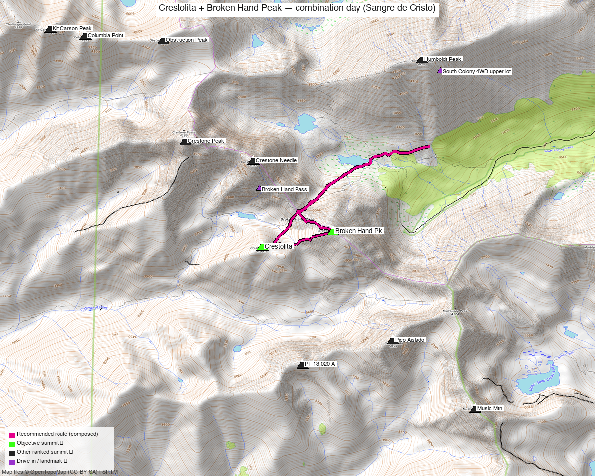
Note: the recommended route was distilled from 21 recorded GPS tracks of real trips (recorded trips) — all layered on the interactive CalTopo research map.
NOAA weather link: Crestolita + Broken Hand Peak Weather
CalTopo research map: https://caltopo.com/m/6TKA0RH
Peaks covered
| Broken Hand Peak | "Crestolita" | |
|---|---|---|
| Elevation (LiDAR) | 13,575' | 13,264' |
| Lat / Lon | 37.95671, −105.56665 | 37.9549, −105.57561 |
| Class (standard) | 3 | 2 (south face) |
| Range / Wilderness | Sangre de Cristo / Sangre de Cristo Wilderness | same |
| peak_db id | 258 | 524 |
The two summits are 0.6 mi apart along the ridge SW of Crestone Needle — a natural, well-established pairing.
Recommended plan — South Colony Lakes ⭐
Both peaks sit above the South Colony basin, reached via Broken Hand Pass (~12,900', the standard Crestone Needle saddle).
Combo stats: roughly ~11–14 mi and ~6,400–7,100 ft, depending on how high you drive the 4WD road. A full alpine day, not a half-day.
- From the South Colony lot, follow the trail toward the lakes / Crestone Needle junction.
- Ascend to Broken Hand Pass.
- Broken Hand Peak (13,575', Class 3): standard line from the pass (NW/west side — not the south ridge, which is a hard technical variant).
- Crestolita (13,264', Class 2): the two don't connect at easy class via the direct ridge (that's the 4th–low-5th "Analemma/South Ridge" traverse). For the non-technical pairing, gain Crestolita via its Class 2 south-facing summit gully.
- Return over Broken Hand Pass to the South Colony trail.
The cleanest easy-class way to bag both may be from Cottonwood Creek (full reasoning in Other considerations).
Getting there — drive + approach (from Highland, Denver)
| Drive from Highland | 3h 26m via Google Maps (162 mi) |
| Primary trailhead | South Colony Lakes 2WD lot (~37.97592, −105.50657, ~9,880') |
| 4WD continuation | South Colony Road continues ~2.5 mi of rough 4WD to the upper lot (~11,000'); a careful stock AWD gets most of the way. |
| Alternate trailhead | Cottonwood Creek (longer, rougher) — better only for Crestolita's Class 2 south face or the north couloirs |
Gear & season
- Best window: mid-June through September. Snow lingers in the couloirs / N aspects into early summer.
- Snow option: Crestolita's north couloirs are a legit spring snow climb (axe/crampons).
- Rock: Crestone-group conglomerate — grippy when dry, loose blocks exist; Broken Hand is a true Class 3 scramble.
- Storms: standard Sangres afternoon risk on exposed ridge — early start, off by early afternoon.
- Permits / access: Sangre de Cristo Wilderness — no permits. San Isabel NF — no fee. South Colony Rd: 2WD to the lower lot, high-clearance 4WD for the upper ~2.5 mi.
- Cell: 14ers community DB has no reports for either summit. Likely dead at the TH/basin; possible signal on the high points (LOS west to the San Luis Valley). Carry an InReach — the terrain is committing.
Other considerations
Cottonwood Creek alternative: the cleanest easy-class way to bag both may be from Cottonwood Creek — each peak has a Class 2 south side, skipping the Broken Hand Pass elevation — at the cost of a longer approach.
Technical alternate 🪨: the Analemma (Crestolita NE Ridge) + South Ridge of Broken Hand linkup is a 5.easy, extreme-exposure, committing scramble (~12 mi / 5,700') — a premier hard Sangres day, not the way to simply tick both. Only for the scramble.
Trip reports & GPX
This pairing is well documented — whileyh (2025), Alyson Kirk (2014), Furthermore (2011) all did exactly these two; Marmot72 and josephnephi did them within Crestone-group days. The shared research map (21 GPX tracks across 14ers + LoJ + peakbagger) is layered at CalTopo 6TKA0RH.
Sources checked: 14ers.com · listsofjohn.com · peakbagger.com