Other climbers: Kyle Knutson — ✓ all · Shawn D Keil — not yet
Vestal, Arrow & the Trinities — Grenadier backpack (Wham Ridge trip)
At a glance — 4-day trip
5 peaks · trip total ~32.7 mi · ~13,318 ft · ~7.6 h drive
- Day 1 — Pack-in (Molas Pass → Vestal Basin camp): 10 mi · 3,077 ft gain · 2,250 ft descent
- Day 2 (Vestal (Wham Ridge) + Arrow): 6.4 mi · 4,282 ft gain · Class 5.4 · 2 peaks
- Day 3 (Trinity traverse (W→E)): 6.3 mi · 3,709 ft gain · Class 4 · 3 peaks
- Day 4 — Pack-out (camp → Molas Pass): 10 mi · 2,250 ft gain · 3,077 ft descent
Written for Emily — all five unclimbed on her 14ers checklist. Vestal, Arrow, and Trinity are centennial (top-100) 13ers; West and East Trinity are bicentennials.
Researched: 2026-07-10
NOAA weather link: Vestal, Arrow & the Trinities Weather
CalTopo research map: https://caltopo.com/m/4MR73J3
Shareable link (sanitized — safe to forward to anyone): https://mtn-share.pages.dev/s/33fc621f3fbca2fe/ — no names, climbed status, or research maps; expires ~2026-11-08 (regenerate anytime: share_report.py vestal_arrow_trinities)
Status for Emily: All five unclimbed. This is the heart of the Grenadiers — quartzite peaks that most consider the most beautiful climbing terrain in the San Juans.
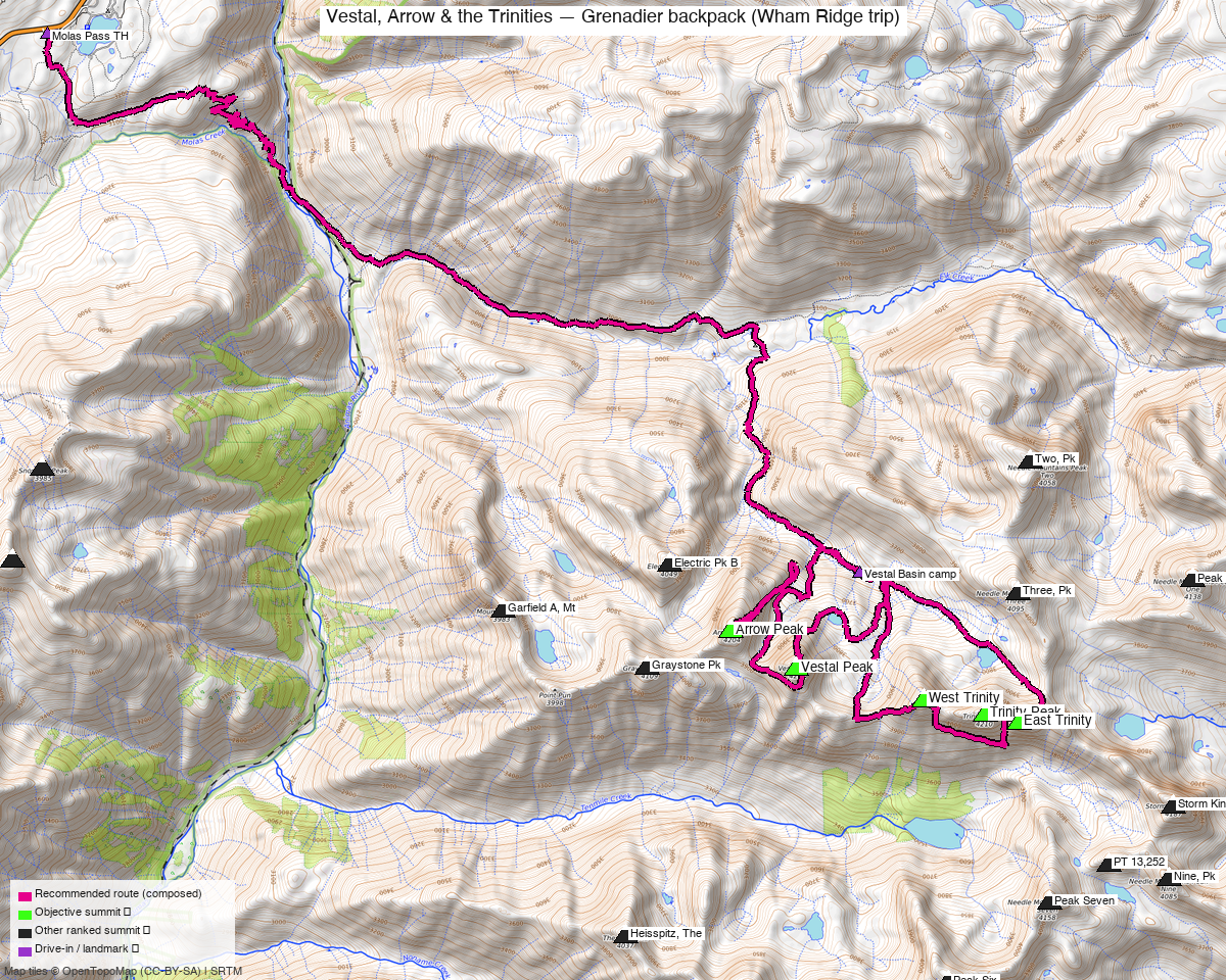
Note: the recommended route was distilled from 33 recorded GPS tracks of real trips (14ers.com · ListsofJohn · peakbagger · Kyle's recordings) — all layered on the interactive CalTopo research map.
Technical trip — Class 4 and low 5th class terrain
- Wham Ridge (Vestal) is an alpine rock route (III 5.4) — careful route-finding keeps it at 5.4 (crux hand crack), off-route quickly becomes 5.6+; most experienced scrambler parties solo it dry, but a light rope + small rack for the upper headwall is common and smart for a first time on it.
- Vestal's descent is a known trap: do not drop into the first gullies off the top (they cliff out into loose Class 4) — traverse the ridge south, then southeast to the further SE-facing gully before descending the choss to the Vestal–Arrow saddle side.
- Trinity Peak's crux on the traverse is a short (~20 ft) exposed Class 4 chimney regaining the ridge from the south-side ledges — cairned, solid rock, but no-fall terrain.
Peaks covered
A backpack via Elk Creek (Colorado Trail) to a Vestal Basin camp (11,300–11,760') — 4 days / 3 nights: pack in, two climbing days, pack out (strong parties compress to 3 days). Hardest move 5.4 (Wham Ridge's crux hand crack); the Trinity day is Class 4.
| Peak | Day | Elev | Route | Class | CO rank |
|---|---|---|---|---|---|
| Vestal Peak | 2 | 13,867' | Wham Ridge (N face) up · S face down | 5.4 (III) | #78 |
| Arrow Peak | 2 | 13,817' | NE/East ramp | 3 | #99 |
| West Trinity | 3 | 13,765' | SW ridge (start of traverse) | 2+/3 | #121 |
| Trinity Peak | 3 | 13,816' | W ridge from W Trinity saddle | 4 (chimney crux) | #100 |
| East Trinity | 3 | 13,752' | W ridge · descend NE ridge | 3 | #128 |
(CO rank = elevation rank among Colorado's ranked 13ers + 14ers.)
All five ring Vestal Basin — summits are ≤1.5 mi apart. The classic combination is exactly Emily's plan: Wham + Arrow one day, the three-Trinity traverse the next.
Getting there — Molas Pass trailhead
- Park at the Colorado Trail / Molas Trail lot just north of Molas Pass on US 550 (37.7476, -107.6885, ~10,610' — gravel lot, any car). This is where 12 of the 30 swept GPX tracks start. US 550 is paved all the way; no 4WD needed.
- Drive from Highland: ~7h 35m / 361 mi via Google Maps to Molas Pass.
- Alternative approach: the Durango & Silverton train to Elk Park cuts ~5 mi and the 1,700' Animas climb out, but chains you to the train schedule — several swept tracks use it (their starts show at the Animas River, ~8,900').
The days, in order
Day 1 — Pack-in: Molas Pass → Vestal Basin
- Colorado Trail from Molas Pass — ~4 mi of switchbacks down to the Animas River bridge (8,900'); you repay this descent on the way out.
- Cross the bridge, then Elk Creek Trail (CT east) up the spectacular Elk Creek canyon to the beaver ponds meadow (~11,200') — the Grenadiers' north walls appear across the valley.
- Just past the beaver ponds, drop right onto the unmaintained Vestal Creek trail (cairned climber's path): steep, braided in places, with deadfall. It climbs ~700' into Vestal Basin.
- Camp in the basin — see Camps & water below (the recommended camps are the lower-meadow/upper-bench pair at 11,300–11,760').
Day 2 — Vestal via Wham Ridge, then Arrow (Class 5.4)
The Grenadiers' marquee day, and one of Colorado's classic alpine rock routes.
- Camp → Vestal–Arrow basin. From the lower meadow, ascend SSW ~600 ft (climber's trail) into the hanging valley between Arrow and Vestal (rock-glacier boulder hopping).
- Wham Ridge (III 5.4). Start up the grassy N-face ledges to the ridge proper. The quartzite is superb — slabby Class 3–4 lower, steepening to the 5.4 crux hand crack high on the face. Careful route-finding keeps it at 5.4; drifting off-line finds 5.6+. Rope/small rack optional for solid scramblers in the dry; bring them if in doubt.
- Descend the S face (Class 2+/3 — see danger box). Ridge S then SE to the correct SE gully; loose choss all the way down to the Vestal–Arrow saddle area.
- Arrow's East ramp (Class 3). From the basin at ~12,200', gain the huge slanting ramp on Arrow's east face — 1,000+ ft of solid slab friction (Class 2+), polished and slick if wet. At ~13,600' exit the ramp's end and scramble the ridge to the airy summit (Class 3).
- Retrace the ramp and drop back to camp.
Parties commonly log 8–14 hours for the pair.
Order matters: do Wham first (N face needs dry rock and you want the crux behind you before weather), then Arrow — its ramp descends fast if storms build.
Day 3 — The Trinity traverse, W→E (Class 4)
Three summits by the classic west-to-east line — climb high, traverse, descend easy.
- West Trinity, SW ridge (Class 2+/3). From the upper basin, gain the Vestal–W Trinity saddle and follow the SW ridge — steep but low-exposure scrambling.
- W Trinity → Trinity Peak (Class 4 — the crux). Descend W Trinity's east ridge to the saddle (Class 2+). Contour on south-side ledges below the ridge cliffs (cairns), to the leaning-cairn chimney: ~20 ft of exposed Class 4 on good rock back to the crest, then one more short exposed step to easier ground and the summit. ~1.5 hr saddle-to-summit is typical.
- Trinity → East Trinity (Class 3). Descend the shallow couloir just S of the ridge (loose — watch rockfall on partners), cross to the saddle, then the W ridge of East Trinity, S side, steepening to Class 3 near the top (Roach's "steep west-facing gully" crux; snow lingers early season).
- Descend E Trinity's NE ridge (Class 2+) to the 13,060' notch (don't drift right), then ~300 ft of scree to tundra. Stroll back past the unnamed lake at 12,396' to camp — a gorgeous finish.
Day 4 — Pack-out: Vestal Basin → Molas Pass
Reverse the approach: mostly down Elk Creek, then the ~1,750 ft climb back up from the Animas to Molas Pass at the end — budget energy (and snacks) for it. (Same corridor as the pack-in, so the map shows one line for both.)
Camps & water
Recommended: the lower meadow (~11,300') below Arrow and Vestal's north faces — the best mix of sites, water, and position for the harder day (Wham starts right above it).
| Camp | Elev | Pros | Cons |
|---|---|---|---|
| Lower meadow ⭐ | ~11,300' | Most/best sites; Vestal Creek water; shortest start for Day 2 (Wham + Arrow right overhead) | Adds ~0.5 mi / ~450' to Day 3; marmot central |
| Upper bench | ~11,760' | Cuts ~1 mi / ~450' off Day 3 (Trinities); climb13ers measures its routes from here | Fewer, smaller, more exposed sites; Day 2 starts with a contour back west |
| Beaver ponds (Elk Creek) | ~11,200' | On the maintained CT — big sites, easy water; good late-arrival fallback | Adds the steep ~700' unmaintained Vestal Creek climb to both climbing days |
Considerations for all three:
- Water: Vestal Creek runs by both basin camps; the ponds have Elk Creek. All reliable season-long (treat). Elk Creek is beside the approach trail nearly the whole way.
- Water on the climbing days: Day 2 — fill at camp; the Arrow/Vestal hanging valley is dry rock glacier. Day 3 — carry the day's water from camp; the 12,396' lake under East Trinity is on the return.
- Marmots (serious): the basin camps are notorious — marmots here chew packs, straps, pole grips, boots, anything salty. Everything inside the tent or hung, always.
- Weather exposure: the higher you camp, the more wind/lightning exposure — the lower meadow has tree shelter, the upper bench little.
- LNT: durable surfaces, established sites, 100'+ from water — this basin sees heavy summer use.
- Split-camp variant: some parties move camp mid-trip (lower meadow for Day 2, upper bench before Day 3) — rarely worth the packing time for the ~1 mi it saves.
Gear & season
- Rock: helmet (mandatory — chossy descents + party rockfall), approach shoes or sticky trail runners for Wham's slab. Light 30 m rope + small rack/harness optional for the Wham crux — decide by the party's soloing comfort at exposed 5.4.
- Snow (early season / June–early July): ice axe recommended on all these routes (climb13ers flags every one); microspikes for the Arrow ramp and Trinity couloirs.
- Camp: bear-appropriate food storage; marmot-proof everything (in-tent or hung).
- InReach/PLB — no cell coverage anywhere in this drainage (deep Weminuche; dead at the TH, in the basin, and on most summits).
- Best window: mid-July through September — you want Wham's quartzite dry. The N face holds snow/wet into early July; afternoon monsoon storms peak mid-July–August.
- Storm strategy: both days top out early. Wham Ridge is a lightning rod — be moving off Vestal by midday. The Trinity traverse has bail options at each saddle back into the basin (S side).
- Weminuche Wilderness (San Juan NF): no permit needed; groups ≤15; standard LNT. Camp on durable surfaces away from the creek.
- The Elk Creek approach shares the Colorado Trail — expect thru-hikers; Vestal Basin itself is quieter but popular on summer weekends.
Trip reports & GPX (all three sources swept)
GPX collected: 30 track files — 14 from 14ers.com GPX libraries, 6 from listsofjohn trip reports, 10 from peakbagger ascents (all five peaks' libraries swept and deduped) — all layered on the CalTopo research map with the two composed day routes in magenta.
14ers.com — the deep beta; these match Emily's exact plan:
- "The Grenadier's Finest — Vestal, Arrow & the Trinities" (16464) — this trip, verbatim
- "Labor Day Weekend in the Grenadiers: Vestal and Arrow" (10973) + "The Trinity Traverse" (11034) — the same 2-day split
- "Arrow today, Trinities tomorrow" (20494) / "Trinity Traverse" (20495)
- "Wham in the Weminuche" (21785) · "Solo Surfin the Wham" (19830) — Wham Ridge detail
- "Vestal Basin 5 in a Day & Centennial FINISH!" (22327) — all five in a single push, for scale
- "Eastern Grenadiers: East Trinity, Trinity, West Trinity and Pack Out" (16643)
listsofjohn.com — 30 TRs seen across the five; 6 downloadable tracks incl. a complete Molas→basin→peaks→Molas trip (gpx 6244) and a 2025 Vestal Basin approach (gpx 18276).
peakbagger.com — 10 ascent tracks (logged in), incl. a clean Trinity-traverse loop (the Trinity-day composed route follows one verbatim).
climb13ers.com — per-route class/terrain detail used throughout (S Face 2+, E Ramp 3, Trinity W Ridge 4, E Trinity W Ridge 3, camp-based mileages).
Sources checked: 14ers.com · listsofjohn.com · peakbagger.com · climb13ers.com