Other climbers: Kyle Knutson — ✓ climbed · Shawn D Keil — ✓ climbed
Gladstone Peak — 13,923' Centennial (San Juan, Wilson group)
At a glance — recommended day
11.3 mi · 4,976 ft gain · Class 4 · 1 peak · ~8 h drive
Written for Emily — the standalone Centennial between Mount Wilson and El Diente, by the shortest recorded day route (Cross Mountain TH / Bilk Basin).
Status for Emily: unclimbed (on her 14ers checklist). CO rank 67, a Centennial (highest 100 in Colorado) — the high prize of this trip.
Gladstone Peak (13,923') is the pyramid wedged between Mount Wilson and El Diente in the Wilson group. Climbed on its own, the shortest recorded line is from the Cross Mountain TH up Bilk Basin — a ~11.3 mi / ~5,000 ft round trip to a short Class 4 move right below the summit (with an easier Class 3 line just left of it). The mountain is notoriously loose; the difficulty is the rock quality and that final summit block, not the mileage.
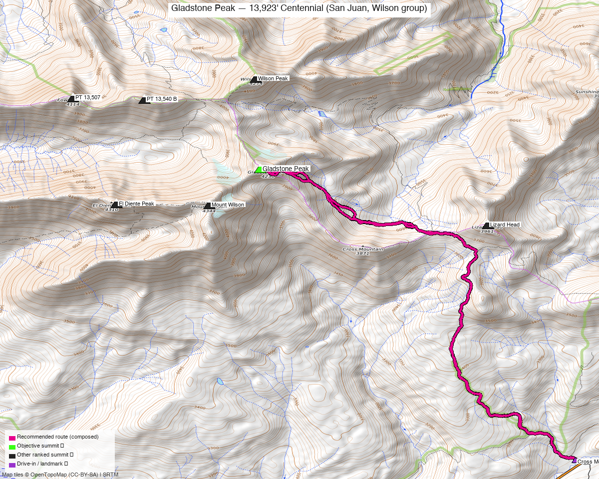
Note: the recommended route was distilled from 12 recorded GPS tracks of real trips (14ers.com · ListsofJohn · peakbagger) — all layered on the interactive CalTopo research map.
Class 4 summit move + very loose rock — this is the hard part
- Class 4 summit move: a short committing pull onto the summit block — a recorded TR (14ers #20763) describes "the true 'Class 4' move to pull to the top" with "a nice Class 3 alternative to the left of it," so the very top goes at stiff Class 3 if you pick the line carefully.
- Rock quality: "I hardly trusted a rock all day" — the upper mountain is steep, loose talus and shifting blocks; helmet on, test every hold, nobody directly below you, and save it for dry, stable conditions (wet or snowy rock here is serious).
NOAA weather link: Gladstone Peak Weather
CalTopo research map: https://caltopo.com/m/1PV10HH
The peak
| Gladstone Peak | |
|---|---|
| Elevation | 13,923' |
| Lat / Lon | 37.84513, −107.98415 |
| Class (standard route) | 4 (short crux move below summit; Class 3 alternative alongside) |
| CO Rank | 67 — Centennial |
| Range | San Juan (Wilson group, Lizard Head Wilderness) |
| 14ers.com | peak 10278 |
| LoJ | 84 |
| peakbagger | Gladstone Peak |
| Peak DB id | 84 |
The route — Cross Mountain TH / Bilk Basin ⭐
The shortest clean Gladstone-only day in the track library (the Navajo Basin / Rock-of-Ages side from the west is a longer day, usually done when combining the Wilsons). Class 4 at the summit, Class 2 talus and tundra below it.
- Line: Cross Mountain TH (CO-145 near Lizard Head Pass, ~10,000′) → Lizard Head / Cross Mountain trail into Bilk Basin (the SE cirque under the Wilson group) → up Gladstone's southeast slopes (steepening, loose talus) → the short Class 4 crux just below the summit (Class 3 line just left).
- Why this side: it's the shortest standalone approach to Gladstone — a roadside CO-145 trailhead, no long basin backpack and less gain than the western (Navajo Basin) approaches.
- Effort, not just grade: still a long, high day with a steep, loose finish.
Getting there — drive + approach (from Highland, Denver)
| Drive from Denver | ~8h via Google Maps — a far-SW-Colorado drive (US-285 / US-50 / US-550 corridor toward Telluride), then CO-145 over Lizard Head Pass. This is a multi-hour drive — plan to camp. (Verify the exact time in Maps.) |
| Trailhead | Cross Mountain TH — ~37.7964, −107.9377, ~10,000', a roadside pullout on CO-145 just SW of Lizard Head Pass. The Cross Mountain / Lizard Head trail leads into Bilk Basin. |
| Land | San Juan NF / Lizard Head Wilderness — foot travel only beyond the TH; no permits/fees. |
Gear & season
- Best window: mid-July through September, once the upper basin and the loose summit slopes are dry and snow-free. The Class 4 crux is much more dangerous with snow/ice or wet rock.
- Terrain: trail + basin to talus; the upper mountain is steep and notoriously loose to a Class 4 finish. Helmet strongly recommended.
- Storms: long exposed day at altitude — very early start, summit early, and be off the loose upper slopes before afternoon weather.
- Cell: unreliable to dead in Bilk Basin — carry an InReach/satellite messenger.
Trip reports & GPX (all sources)
All three sources swept (counts verified, not assumed): 9 distinct recorded GPX tracks all summit Gladstone — from both the Cross Mountain / Bilk Basin side (east) and Navajo Basin (west). The recommended route is the shortest clean Gladstone-only day (Cross Mountain, DEM-measured off that track).
- 14ers.com — 6 GPX tracks (deduped from the 9 library entries). Route beta + the #20763 trip report documenting the Class 4 summit move / Class 3 alternative and the loose rock ("I hardly trusted a rock all day"). (peak 10278)
- peakbagger.com — 3 GPX tracks (ascents with uploaded GPS; pid 5817). One independently starts at the Cross Mountain TH — corroborating the trailhead.
- listsofjohn.com — no downloadable GPX (peak 84 hosts text trip reports only); used for class/rank confirmation (Class 3, CO rank 67).
- climb13ers.com: Gladstone Peak route notes (Wilson group).
Sources checked: 14ers.com ✓ (6 tracks) · peakbagger.com ✓ (3 tracks) · listsofjohn.com ✓ (no GPX, text TRs) · climb13ers.com ✓