Other climbers: Kyle Knutson — ✓ all · Shawn D Keil — not yet
Lakes of the Clouds — 7-peak loop (northern Sangre de Cristo)
At a glance — recommended day
20.8 mi
Written for Emily — all seven unclimbed on her 14ers checklist.
Status for Emily: All seven unclimbed. A horseshoe of ranked 13ers ringing the Lakes of the Clouds, northern Sangres.
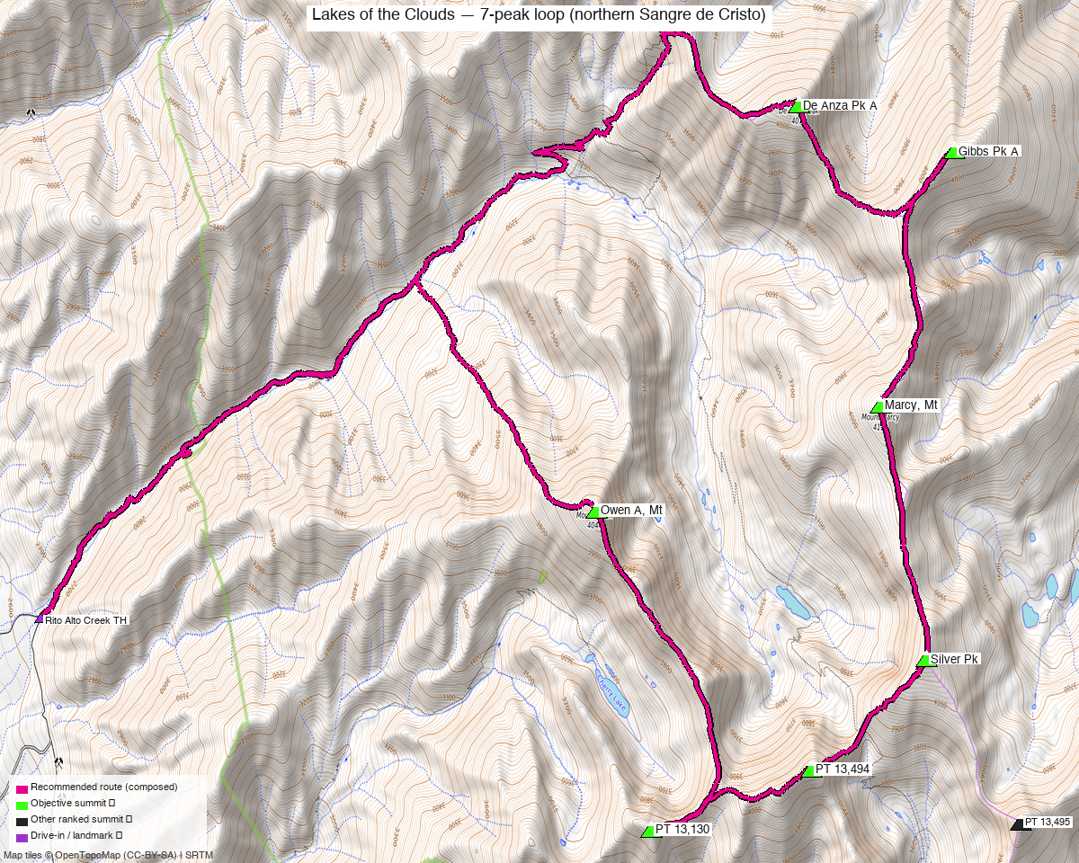
Note: the recommended route was distilled from 68 recorded GPS tracks of real trips (Kyle's recordings) — all layered on the interactive CalTopo research map.
NOAA weather link: Lakes of the Clouds Weather
CalTopo research map: https://caltopo.com/m/J9G39T0
Peaks covered
In rough ridge order around the cirque (N → S → back):
| # | Peak | Elevation | Class | peak_db |
|---|---|---|---|---|
| 1 | De Anza Peak A | 13,391' | 2 | 431 |
| 2 | Gibbs Peak A ⭐ high point | 13,577' | 2 | 272 |
| 3 | Mt Marcy | 13,504' | 2 | 327 |
| 4 | "Silver Peak" | 13,517' | 2 | 307 |
| 5 | PT 13,494 ("Cotton King") | 13,494' | 2 | 326 |
| 6 | PT 13,130 | 13,130' | 2 | 694 |
| 7 | Owen A, Mt | 13,361' | 2 | 446 |
All Class 2 on the standard lines — the difficulty here is distance, gain, and ridge route-finding, not technical climbing.
Weather: NOAA forecast for the cirque (Mt Marcy / Lakes of the Clouds — covers the whole loop at this resolution; same target as the 14ers / LoJ / peakbagger weather links).
Recommended plan — Lakes of the Clouds horseshoe ⭐
The seven ring the Lakes of the Clouds cirque. The natural line climbs to the lakes, gains the ridge, and traverses the horseshoe, tagging summits along the crest.
Loop stats: the full seven is a very big outing — on the order of ~15–24 mi and ~8,000–12,000 ft depending on the exact line and which THs you link. Individual arcs (per the logged tracks) run ~6–14 mi.
Two ways to do it:
- Two days (recommended) — backpack to a camp near the Lakes of the Clouds, then split the ridge into a north arc (De Anza · Gibbs · Marcy · Silver) and a south arc (Cotton King/PT 13,494 · PT 13,130 · Owen) on either side of the camp. This is how josephnephi did it (2024: north arc one day, south arc the next).
- One long push — a huge single-day horseshoe for the very fit (expect 24 mi / 12,000 ft class numbers on the bigger logged tracks). Alpine start, all-day commitment.
Study the GPX on the research map for the exact ridge sequence — the connecting ridges are Class 2 but have route-finding, false summits, and a few drops/regains between peaks. There's no single "standard route" sign here; the logged tracks are the beta.
Getting there — drive + approach (from Highland, Denver)
| Drive from Highland | 3h 24m via Google Maps (183 mi) to the Wild Cherry Creek TH (San Luis Valley, near Moffat) |
| East approach (most documented) | Gibson Creek TH (Gibson Trailhead), Wet Mountain Valley near Westcliffe — the trailhead most 14ers TRs use for these peaks (De Anza/Gibbs/Marcy via Gibson Creek + the Rainbow Trail) |
| West approach | Cotton Creek / Wild Cherry Creek / Rito Alto Creek from the San Luis Valley side (Moffat) — the line the logged loop GPX on the research map follow |
| Vehicle | Dirt forest roads to the THs; 2WD-passable in dry conditions, rough/muddy when wet |
Gear & season
- Best window: July–September for dry Class 2 tundra/talus and the dirt approach roads. Snow lingers in the cirque into early summer (several logged tracks are late-May with snow).
- Terrain: high tundra, talus, and grassy/rocky ridges — solid Sangre Class 2, but long exposed ridgelines.
- Water: the Lakes of the Clouds + creek drainages make a 2-day camp easy to supply (treat).
- Storms: you're on exposed ridge for hours — early start, and have a bail plan off the ridge into the basin if weather builds.
- Length is the hazard: big mileage + gain at 13k. Pace, fuel, and turnaround discipline matter more than any move on the route.
- Permits / access: Sangre de Cristo Wilderness (Rio Grande / San Isabel NF) — no permits required; standard wilderness rules (no motorized, groups ≤ 15, leash/control dogs). Dispersed camping near the lakes is allowed under Leave No Trace; camp on durable surfaces away from water.
- Cell coverage: no 14ers.com community-DB reports for these summits. The cirque and west-side approaches are deep behind the range crest — expect dead at the THs and lakes; summits/high ridge may catch intermittent signal toward the San Luis Valley (west) but don't rely on it. Carry an InReach — this is a long, committing, remote multi-peak day/overnight.
Other considerations
Which side of the range? The seven can be linked from either side. The logged loop tracks on the research map are the west (SLV) approach — Wild Cherry Creek, the drive-time target above. Many 14ers parties use Gibson Creek (east) from the Wet Mountain Valley instead — check both before committing, depending on which THs you want to start/finish at.
Trip reports & GPX (all three sources)
The loop is well documented as N + S arcs:
14ers.com has extensive TRs for these peaks (69 across the seven) — the multi-peak ones are the loop beta:
- "Traverse from Cottonwood Pk to Mt Owen in the Sangres" (18396) — the big ridge traverse covering this whole zone
- "Sangre 13ers: De Anza, Gibbs, and Marcy" (18633) — the north-arc trio
- "Cotton Creek 13ers (Sangre de Cristos)" (17527) — west-side Cotton Creek approach
- "Central Sangre 5 pack" (10455) · "This Trip Report goes to Eleven!" (14262) — multi-peak days
- "De Anza Peak A - Gibson Trailhead" (11708) / "From Gibson Trailhead" (21454) — the east (Gibson Creek) approach
listsofjohn.com loop tracks (37 TRs across the seven): whileyh 2020 N arc (8083 ⭐), josephnephi 2024 N (15989) + S (15992 ⭐), Alyson Kirk 2014 S (978).
peakbagger.com (logged in, Kyle Knutson): 8 ascent GPX tracks across the seven, layered on the map.
Kyle's own CalTopo tracks (his recorded GPS + collected archive) add the on-the-ground beta the web sources miss — incl. Cotton Creek 13ers, Gibbs Peak loop, Rito Alto–Hermit–Eureka, Lakes/Electric, and several recorded GPX dumps. Layered in purple on the research map.
GPX collected: 60 track files across all sources — LoJ + 14ers (swept via scripts/sweep_gpx.py; 69 named 14ers TRs + 37 LoJ TRs in the manifest) + 16 of Kyle's own CalTopo tracks (scripts/caltopo_mytracks.py) — all layered on the CalTopo research map.
Sources checked: 14ers.com · listsofjohn.com · peakbagger.com