South San Juans 3-Day — 5 summits across the South San Juan Wilderness
Other climbers: Emily Sharpe — 4 of 5 (Bennett Peak, Summit Peak, The Unicorn, Montezuma Peak) · Shawn D Keil — 3 of 5 (Summit Peak, The Unicorn, Montezuma Peak)
At a glance — 3-day trip
5 peaks · ~7 h drive
- Day 1 (Day 1 — Bennett Pk): 6.1 mi · 2,168 ft gain · Class 2 · 1 peak
- Day 2 (Day 2 — Summit Pk + Unicorn + Montezuma): 8.8 mi · 3,374 ft gain · Class 2 · 3 peaks
- Day 3 (Day 3 — Conejos Pk): 6 mi · 2,008 ft gain · Class 2 · 1 peak
Drive from Boulder: 7h 00m via Google Maps
CalTopo research map: https://caltopo.com/m/858FU6V
Researched: 2026-08-18
Status in Peak Checklist: all five unclimbed — a meaningful block addition to Kyle's Colorado 13er list. The South San Juan Wilderness sees far fewer parties than the Elks or Sawatch, so these are genuinely remote Class 1–2 summits that reward the long drive.
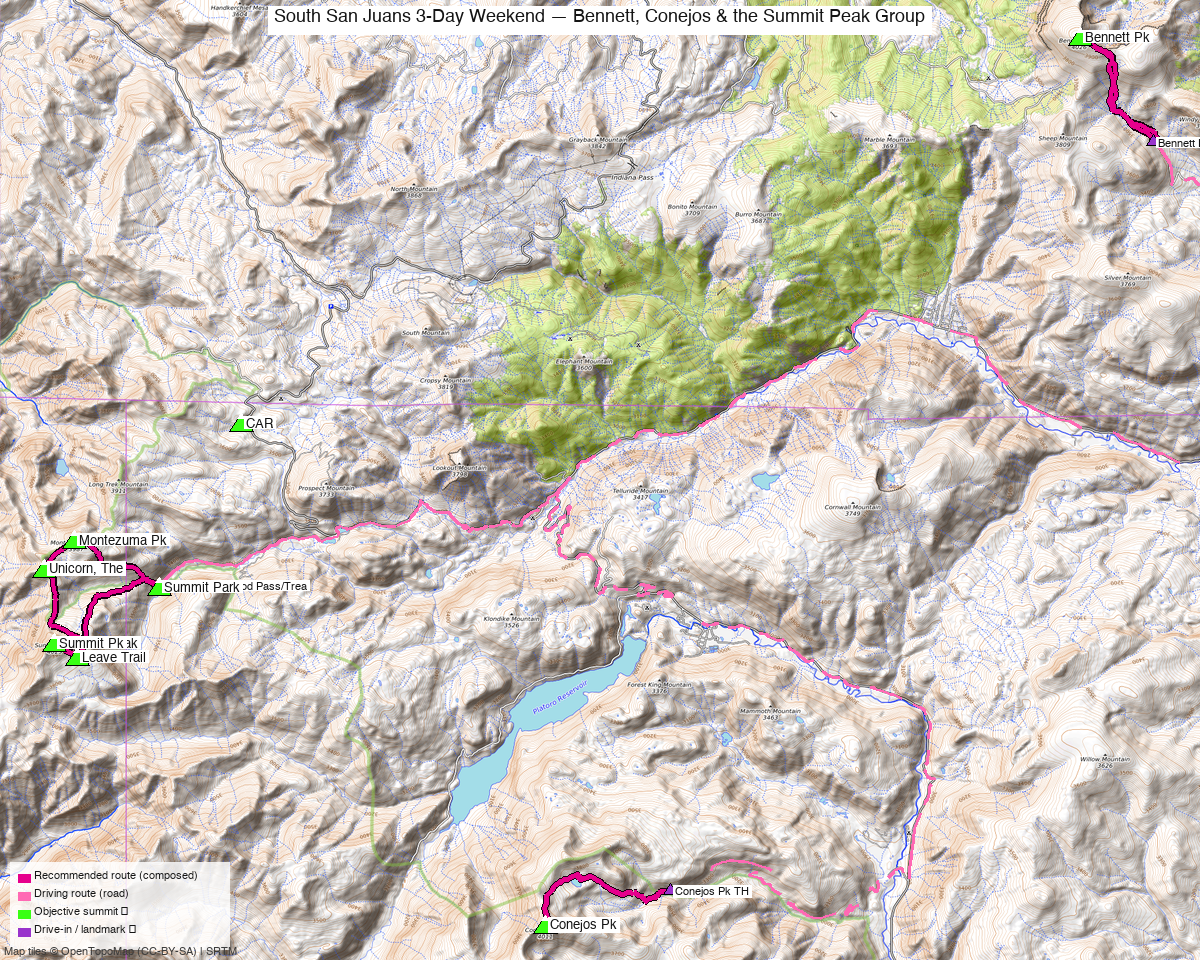
Note: the recommended route was distilled from 21 recorded GPS tracks of real trips (14ers.com · ListsofJohn · peakbagger) — all layered on the interactive CalTopo research map.
Peaks covered
Five ranked 13ers scattered across the South San Juan Mountains in the South San Juan Wilderness — a remote, lightly-visited corner of the Colorado high country straddling Rio Grande and San Juan National Forests. No permits or fees; cattle grazing is active around Conejos and near several gates on the approaches. The three trailheads share zero approach infrastructure, so this is a driving loop (not a backpack linkup): FS 265 on the Del Norte side for Bennett, CO-149 / Treasure Creek for the Summit trio, and CO-17 / Saddle Creek for Conejos.
| Peak | Elev | Class | CO rank | Day | Status |
|---|---|---|---|---|---|
| Bennett Pk | 13,206' | 1 | — | 1 | unclimbed |
| Summit Pk | 13,304' | 2 | — | 2 | unclimbed |
| Unicorn, The | 13,030' | 2 | — | 2 | unclimbed |
| Montezuma Pk | 13,158' | 2 | — | 2 | unclimbed |
| Conejos Pk | 13,176' | 2 | — | 3 | unclimbed |
Day 1 — Day 1 — Bennett Pk
6.1 mi · ~2,168 ft, Class 1 — a pure tundra trail from the FS 265 trailhead on the Del Norte side, rated Class 1 by climb13ers: "We rate Bennett as a Class 1 hike." Expect a fence/gate at the trailhead, abundant wildflower meadows, and no exposure anywhere on the route. The line is the Kyle-validated CalTopo round trip from the South Fork Rock Creek / Bennett Pk TH — a converted-GPS track with walking-cadence spacing and a stationary-start signature at the gate, admitted via visual inspection and format-conversion forensics. Bennett is the closest trailhead to Boulder, so it's climbed on the drive in.
Day 1 sequence
- Bennett Pk TH (11,185') — pass through the fence/gate at the trailhead and head north on the maintained tundra trail.
- Follow the trail through open wildflower meadows with a steady, sustained climb (~2,000 ft net rise over ~3 miles).
- Bennett Pk summit (13,206') — broad, grassy top; no exposure, Class 1 the entire way.
- Return the same trail to the TH (6.1 mi round trip, ~2,168 ft total gain).
Day 2 — Day 2 — Summit Pk + Unicorn + Montezuma
8.8 mi · ~3,374 ft, Class 2 — the day's technical crux is Summit Pk's Class 2 east-ridge ascent on embedded rock; the traverse to Unicorn and Montezuma is "a pleasant, mostly tundra-stroll" (climb13ers). The connecting tundra ridge between all three summits is broad and straightforward — a 2024-08 summer recording (trk_14ers_7.gpx, 8.8 mi) covers the full circuit with clean geometry and no detours. Note: the beetle-kill closure affecting Summit Pk's west-fork direct (Option 2 on climb13ers) doesn't touch the recommended east-ridge route (Option 1).
Day 2 sequence
- Treasure Creek TH (10,950') — head south up the Treasure Creek drainage toward the ridgeline.
- Ascend the east ridge to Summit Pk (13,304') — the day's high point and its Class 2 crux; embedded rock on the upper ridge.
- Traverse the tundra ridge north to Unicorn / The Unicorn (13,030', Class 2) — ~1.1 mi from Summit Pk.
- Continue north-northeast along the ridge to Montezuma Pk (13,158', Class 2) — ~0.5 mi further.
- Descend back to Treasure Creek TH (8.8 mi total, ~3,374 ft gain).
Day 3 — Day 3 — Conejos Pk
6.0 mi · ~2,008 ft, Class 2 — climb13ers calls Conejos "an easy Class 2 that crosses a lot of tundra terrain." Trail #722 climbs eight switchbacks to the east ridge; from there it's open tundra to the summit. The best available recording is a June 2026 shoulder-season track (trk_pb_7.gpx, 6.0 mi), which matches climb13ers' 5.6 mi RT closely — no summer recording exists from this corridor yet, but the lower-latitude South San Juan terrain melts out early and a June line is well-precedented. Watch for cattle fences/gates on the approach.
Day 3 sequence
- Saddle Creek - Conejos TH (11,150') — pick up Trail #722 from the trailhead; pass through any cattle fencing at the start.
- Climb 8 switchbacks on Trail #722 to gain the east ridge.
- Follow the broad tundra ridge to Conejos Pk summit (13,176') — Class 2, no exposure.
- Return the same trail to the TH (6.0 mi round trip, ~2,008 ft gain).
Getting there — Bennett Pk TH (11,185')
| Drive from Boulder | 7h 00m via Google Maps |
| Trailhead | Bennett Pk TH, 37.460199, -106.414769, 11,185' |
| Road | Bennett Peak Road (FS 265) off County Road 15, southeast of Del Norte — climb13ers confirms passenger car accessible (extra clearance helpful on the unpaved stretch). OSM way 681539110. |
| Land | Rio Grande / San Juan National Forests, South San Juan Wilderness. No permits, no fees; self-issued Wilderness entry. |
This is a driving loop — each day uses a different trailhead. Suggested car-camp legs:
| Leg | Drive | Destination |
|---|---|---|
| Boulder → Day 1 | ~7h 00m / 261 mi | Bennett Pk TH (FS 265), 37.460199, −106.414769 |
| Day 1 TH → Day 2 | ~1h 15m | Treasure Creek TH (CO-149), 37.3629, −106.6700 |
| Day 2 TH → Day 3 | ~1h 00m | Saddle Creek - Conejos TH (FR 105 / CO-17), 37.2958, −106.5387 |
| Day 3 TH → Boulder | ~7h 00m | Home |
Day 2 — Treasure Creek TH (10,950'): Treasure Creek Road off CO-149 in the South Fork area, unpaved Forest Service road (OSM way 265000013), passenger car. Day 3 — Saddle Creek - Conejos TH (11,150'): Saddle Creek Road (FR 105) off CO-17 north of Antonito, unpaved, passenger car with high clearance preferred (OSM way 1302533286).
Gear & season
- Best window: late June through September. The South San Juan Wilderness melts out relatively early for its latitude — the June 2026 Conejos recording shows passable conditions by the start of summer. Track-seasons evidence: summer (July–August) recordings dominate for the Summit trio corridor; the shoulder-season (June) Conejos recording is the best available. Avoid snow-season tracks (May) flagged in the track review — three May tracks excluded as WINTER.
- Terrain: all three days are sustained tundra with no technical rock. Bennett is Class 1 (pure trail); Summit Pk's east ridge is the trip's Class 2 crux (embedded rock, no exposure); Unicorn, Montezuma, and Conejos are Class 2 tundra. Trail shoes are fine; no helmet needed.
- Cattle: active grazing in the South San Juan Wilderness — expect fences and gates on the Bennett approach and around the Conejos corridor. Leave gates as found.
- Storms: all three days are open tundra ridges. Standard alpine starts — aim off summits by noon; both Day 2 (summit-to-summit traverse) and Day 3 (east-ridge return) expose you above treeline for extended stretches.
- Cell: minimal coverage in the South San Juans. InReach as usual; Del Norte and South Fork have service en route.
Other considerations
Mileage floor: the composed lines (6.1 / 8.8 / 6.0 mi) are the measured minimum from the route geometry. Budget time above those numbers — a Day 2 traverse over three summits on open tundra will run longer than the composed spine.
No nearby add-ons: find_peaks_near checked all three clusters at the extended 12-mile radius (applied because drive_h ≥ 4). No additional ranked unclimbed 13ers fell within that radius of any cluster — these five objectives are genuinely isolated in the South San Juan Wilderness. This trip stands alone; there is no obvious tack-on.
Summit trio day alternatives: climb13ers notes a west-fork direct approach to Summit Pk (Option 2) through beetle-kill closures. That option is currently blocked; the east-ridge route (Option 1, which the recording uses) is unaffected.
Day order rationale: Bennett is climbed on the drive in from Boulder (closest TH, Del Norte side) — this avoids a dedicated out-and-back to the northeast corner of the trip. The logical sequence is Boulder → Bennett → Treasure Creek → Conejos → home, matching Kyle's Google Maps routing.
Trip reports & GPX (all three sources)
Sources confirmed logged in: 14ers.com ("Basin"), listsofjohn.com ("letsgocu"), peakbagger.com ("Kyle Knutson"). All three swept fresh for this build, plus the mapped OSM trails in the bbox — all layered on the research map.
-
14ers.com: 11 track(s) harvested — pages 10509 (Bennett) / 10522 (Conejos) / 10459 (Summit) / 10594 (Unicorn) / 10536 (Montezuma); best summer coverage for the Summit trio corridor (trk_14ers_7.gpx, August 2024, selected for Day 2).
-
listsofjohn.com: 13 track(s) harvested (+11 duplicate(s) of another source) — peaks 607 / 633 / 488 / 796 / 654; cross-verified pids and YDS class (Class 2 confirmed for Unicorn pid 796 from cached LoJ page; LiDAR elevations noted for Montezuma +8 ft and Conejos +4 ft).
-
peakbagger.com: 20 track(s) harvested (+19 duplicate(s) of another source) — peaks 5880 / 5883 / 5882 / 70845 / 16087; best coverage for Conejos Pk (trk_pb_7.gpx, June 2026, selected for Day 3); majority of tracks were duplicates of 14ers.com/LoJ recordings already harvested.
Sources checked: 14ers.com ✓ (logged in, "Basin") · listsofjohn.com ✓ (logged in, "letsgocu") · peakbagger.com ✓ (logged in, "Kyle Knutson")